
Sunny Side is a city in Spalding County, Georgia, United States. The population was 203 in 2020.
Tlalixcoyan is a municipality in the Mexican state of Veracruz. In Tlalixcoyan the main indigenous language is the Chinantec.
Chu Chua Cottonwood Provincial Park is a provincial park in British Columbia, Canada, located 80km north of Kamloops and incorporating a group of forested islands in the floodplain of the North Thompson River.
Nicolum River Provincial Park, formerly Nicolum Provincial Park, is a provincial park in British Columbia, Canada, located at the confluence of the Nicolum and Coquihalla Rivers near the town of Hope. The park is a Class A, category 6 Provincial Park.

Kráľ is a village and municipality in the Rimavská Sobota District of the Banská Bystrica Region of southern Slovakia.
Riečka is a village and municipality in the Rimavská Sobota District of the Banská Bystrica Region of southern Slovakia. Its Hungarian name is Sajórecske.

Zaytsevo is a village in Vyborgsky District of Leningrad Oblast, Russia. Before the Continuation War, the village was called Inkilä. The station of the Vyborg–Joensuu railroad situated in Zaytsevo is called Inkilya (Инкиля).
Yarmouk is an upmarket neighborhood (67th) located within Mansour district in Baghdad, Iraq, and adjacent to Baghdad Airport Road. It was once home to numbers of high-ranking officials from Abd-Alkareem qasim times. Yarmouk is now inhabited by people from both the Shia and Sunni sects, while it used to be the home of many Sunni officials during Saddam Hussein's rule.

Ghazaravan is a village in the Ashtarak Municipality of the Aragatsotn Province of Armenia. Nearby, there are Bronze Age fortresses.
Sidani is a settlement in the Java district of South Ossetia.
Banabona is a village in the Kotli District of Azad Kashmir, Pakistan. Neighbouring settlements include Bindian, Majwal and Marhota.
Vũ Xá is a commune (xã) and village in Lục Nam District, Bắc Giang Province, in northeastern Vietnam.

Baring is an unincorporated community in Saskatchewan. It is located south-east of Grenfell, just off Highway 47.

Kirklionys is a village in Varėna district municipality, in Alytus County, in southeastern Lithuania. According to the 2001 census, the village has a population of 3 people.

Bratmilovce is a suburban area in the municipality of Leskovac, Serbia. According to the 2002 census, the town has a population of 3531 people.

Cedon is an unincorporated community in Caroline County, in the U.S. state of Virginia.
Verići is a village in the municipality of Banja Luka, Republika Srpska, Bosnia and Herzegovina.
Kupusina is a village in the municipality of Velika Plana, Serbia. According to the 2002 census, the village has a population of 267 people.
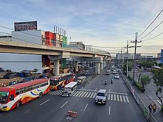
The Regalado Highway, officially named as Regalado Avenue (North), 2.8-kilometer (1.7 mi), four-to-six-lane highway connecting Quirino Highway with Commonwealth Avenue. It is a main thoroughfare in the Barangay Greater Lagro to Mindanao Avenue and of the Neopolitan Business Park. It is named Regalado Highway to distinguish it from the nearby Regalado Avenue which is also a main road in the North Fairview area.
Veto is an unincorporated community in Washington County, in the U.S. state of Ohio.
