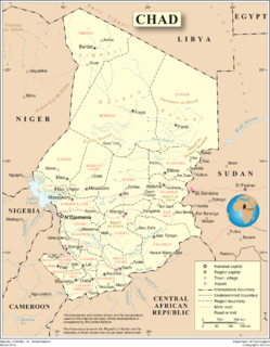
Chad is one of the 48 landlocked countries in the world and is located in North Central Africa, measuring 1,284,000 square kilometers (495,755 sq mi), nearly twice the size of France and slightly more than three times the size of California. Most of its ethnically and linguistically diverse population lives in the south, with densities ranging from 54 persons per square kilometer in the Logone River basin to 0.1 persons in the northern B.E.T. (Borkou-Ennedi-Tibesti) desert region, which itself is larger than France. The capital city of N'Djaména, situated at the confluence of the Chari and Logone Rivers, is cosmopolitan in nature, with a current population in excess of 700,000 people.

Chad, officially known as the Republic of Chad, is a landlocked country in north-central Africa. It is bordered by Libya to the north, Sudan to the east, the Central African Republic to the south, Cameroon to the south-west, Nigeria to the southwest, and Niger to the west.
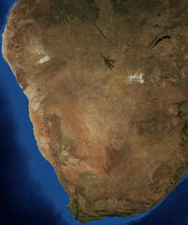
The Kalahari Desert is a large semi-arid sandy savannah in Southern Africa extending for 900,000 square kilometres (350,000 sq mi), covering much of Botswana, and parts of Namibia and South Africa.

Lake Chad is a historically large, shallow, endorheic lake in central Africa, which has varied in size over the centuries. According to the Global Resource Information Database of the United Nations Environment Programme, it shrank by as much as 95% from about 1963 to 1998. The lowest area was in 1986, at 279 km2 (108 sq mi), but "the 2007 (satellite) image shows significant improvement over previous years." Lake Chad is economically important, providing water to more than 30 million people living in the four countries surrounding it on the central part of the Sahel. It is the largest lake in the Chad Basin.

The Ubangi River, also spelled Oubangui, is the largest right-bank tributary of the Congo River in the region of Central Africa. It begins at the confluence of the Mbomou and Uele Rivers and flows west, forming the border between Central African Republic (CAR) and Democratic Republic of the Congo. Subsequently, the Ubangi bends to the southwest and passes through Bangui, the capital of the CAR, after which it flows south – forming the border between Democratic Republic of the Congo and Republic of Congo. The Ubangi finally joins the Congo River at Liranga.

The Okavango River is a river in southwest Africa. It is the fourth-longest river system in southern Africa, running southeastward for 1,600 km (990 mi). It begins at 1,300 m altitude in the sandy highlands of Angola, where it is known by the Portuguese name Rio Cubango. Farther south, it forms part of the border between Angola and Namibia, and then flows into Botswana. The Okavango does not have an outlet to the sea. Instead, it discharges into the Okavango Delta or Okavango Alluvial Fan, in an endorheic basin in the Kalahari Desert.
Lake Makgadikgadi was a paleolake that existed in what is now the Kalahari Desert in Botswana from 2,000,000 years BP to 10,000 years BP. It may have once covered an area of from 80,000 to 275,000 km2 and was 30 m deep. The Okavango, Upper Zambezi, and Cuando rivers once all emptied into the lake. Its remains are seen in the Makgadikgadi salt pans, one of the largest salt pans in the world.

The Cuando River is a river in south-central Africa flowing through Angola and Namibia's Caprivi Strip and into the Linyanti Swamp on the northern border of Botswana. Below the swamp, the river is called the Linyanti River and, farther east, the Chobe River, before it flows into the Zambezi River.

Central Africa is a subregion of the African continent comprising various countries according to different definitions. Angola, Burundi, Cameroon, the Central African Republic, Chad, the Democratic Republic of the Congo, the Republic of the Congo, Equatorial Guinea, Gabon, Rwanda, and São Tomé and Príncipe are members of the Economic Community of Central African States (ECCAS). Six of those states are also members of the Economic and Monetary Community of Central Africa (CEMAC) and share a common currency, the Central African CFA franc.
Gloeocapsa is a genus of cyanobacteria. The cells secrete individual gelatinous sheaths which can often be seen as sheaths around recently divided cells within outer sheaths. Recently divided cell pairs often appear to be only one cell since the new cells cohere temporarily. They are also known as glow caps, a term derived from the yellowish hue given off by the cap.

Trona (trisodium hydrogendicarbonate dihydrate, also sodium sesquicarbonate dihydrate, Na2CO3•NaHCO3•2H2O) is a non-marine evaporite mineral. It is mined as the primary source of sodium carbonate in the United States, where it has replaced the Solvay process used in most of the rest of the world for sodium carbonate production.

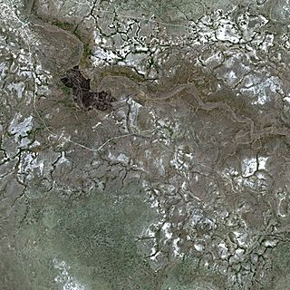
The Makgadikgadi Pan, a salt pan situated in the middle of the dry savanna of north-eastern Botswana, is one of the largest salt flats in the world. The pan is all that remains of the formerly enormous Lake Makgadikgadi, which once covered an area larger than Switzerland, but dried up tens of thousands of years ago. Recent studies of human mitochondrial DNA suggest that modern Homo sapiens first began to evolve in this region some 200,000 years ago, when it was a vast, exceptionally fertile area of lakes, rivers, marshes, woodlands and grasslands especially favorable for habitation by evolving hominins and other mammals.

The Kalahari Basin, also known as the Kalahari Depression or the Okavango Basin, is an endorheic basin and large lowland area covering over 2.5 million km2 covering most of Botswana and Namibia, as well as parts of Angola, South Africa, Zambia, and Zimbabwe. The outstanding physical feature in the basin, and occupying the centre, is the large Kalahari Desert.

Kubu Island (Ga'nnyo) is a dry granite rock island located in the Makgadikgadi Pan area of Botswana. The island is located a few kilometers away from Orapa and Letlhakane mining towns and can be accessed through Mmatshumo in the Boteti district. The entire island is a national monument, and is considered a sacred site by the indigenous people of the area.

Mopipi is a village in Central District of Botswana. It is located close to Makgadikgadi Pan. The population was 3,066 in 2001 census. This area has witnessed steady aridification and desertfication since the Pleistocene, but perhaps most dramatically since the 19th century. In particular, the Boteti River used to flow year around in this area on its way to discharge to the Makgadikgadi Pans, but presently this flow is only in the rainy season.
Branchinella spinosa is a species within the family Thamnocephalidae. This fairy shrimp species occurs in parts of Southern Africa, notably the Makgadikgadi Pans of Botswana. Other crustacean species found in this region of Botswana in co-existence with B. spinosa include Moina belli.
The Ntwetwe Pan is a large salt pan within the Makgadikgadi region of Botswana. The Ntwetwe is one of three large pans within the Makgadikgadi, the other two being Nxai Pan and Sua Pan. Ntwetwe Pan is now a seasonal lake with filling occurring in the rainy season. Ntwetwe was first described to the European world by David Livingstone, pursuant to his explorations in this region. Significant archaeological recoveries have occurred within the Nwetwe Pan, including Stone Age tools from people who lived in this area, in an earlier time of prehistory when a large year round lake occupied the Nwetwe Pan area within the Makgadikgadi.
The Sua Pan or Sowa Pan is a large natural topographic depression within the Makgadikgadi region of Botswana. It is located near the village of Sowa, whose name means salt in the language of the San. The Sua salt pan is one of three large pans within the Makgadikgadi, the other two being Nxai Pan and Nwetwe Pan.
Paradiaptomus africanus is a species of copepod in the family Diaptomidae. As an example occurrence, Lovenula africana is found within the Makgadikgadi Pans, a seasonal hypersaline wetland in Botswana.
