Dapodi

Last updated

Dapodi
Suburb
View of Bridge No. 184-1 from STP in Dapodi.jpg
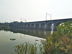
Dapodi railway bridge
India Maharashtra location map.svg
Red pog.svg
Dapodi
Location in Maharashtra, India
Coordinates: 18°34′53″N73°49′50″E / 18.581437°N 73.830421°E / 18.581437; 73.830421
CountryFlag of India.svg  India
State Maharashtra
City Pune
Languages
  Official Marathi, Hindi & English
Time zone UTC+5:30 (IST)
PIN
411012 [1]
Vehicle registration MH 14, MH 12
Civic agencyPCMC
Dapoorie railway bridge in 1858. Dapoorie viaduct, Poona, 1858.jpg
Dapoorie railway bridge in 1858.

Dapodi (earlier: Dapoorie) is a neighbourhood in Pimpri Chinchwad in the northwestern city limits of Pune, India. It is located in the northwest area of the city. Dapodi is situated on the banks of Pavana river and Mula River.The whole area of Dapodi (Pin code 411012) compromises of Phugewadi, Kundan Nagar, Dapodi gaon, Dapodi bazar and Ganesh Nagar.

Contents

The neighbourhood lies on National Highway 48 (India). It is served by Dapodi railway station which falls on Mumbai–Chennai line. The railway station opened in 1858.

Government establishments

  1. College of Military Engineering, Pune [2]
  2. MSRTC Central Workshop (S.T. Workshop) [3]
  3. Irrigation Department Mechanical Workshop

Schools

  1. Kendriya Vidyalay CME
  2. St Mary's Convent Preschool
  3. Hutatma Bhagat Singh High School
  4. Swami Vivekananda Vidyamandir and Junior College

Banks

  1. Bank Of Maharashtra
  2. union bank of India
  3. Axis Bank
  4. Pune District Central Co. Op. Bank
  5. State Transprt Co-operative Bank
  6. Pavana Sahakari Bank

Religious places

  1. Datt Mandir
  2. Ganesh Mandir
  3. Mata Shitaladevi Mandir
  4. Firangai Devi Mandir
  5. Maruti Mandir
  6. Vithoba Mandir
  7. Jain Mandir
  8. Bauddha Vihar (Trailokya Bauddha Mahasangha Bauddha Vihara) [4] [5]
  9. Vineyard Workers of Christ Church (Rev. Peter Silway and Rev. Jayashri Silway)
  10. Salvation Army Church
  11. Holy cross Church (Catholic)
  12. Jama Masjid
  13. Tayyab Masjid (Ahle sunnat Wal Jamaat Deobandi)

Restaurants

  1. Tilak Restaurant & Bar
  2. Silver Bowl Bar & Restaurant
  3. Hotel Amantran (Pure Veg)
  4. Pizza Hut
  5. McDonald's

Location

The surrounding areas are: Bopodi, Bopkhel, Kalas, Kasarwadi, Pimple Gurav and Sangvi. [6]

Related Research Articles

<span class="mw-page-title-main">Sangli</span> City in Maharashtra, India

Sangli is a metropolitan town and the headquarters of Sangli District in Maharashtra, in south-western India. It has earned the nickname "Turmeric City of India" for being the hub of the Asia's largest production and trade of this spice. Sangli is situated on the banks of river Krishna and houses many sugar factories. A significant city in South-Western India, it lies 376 km from Mumbai, 230 km from Pune and 638 km from Bangalore. The city has a significant healthcare hub, including its twin City Miraj. Sangli-Miraj combined has more than 1000+ Hospitals and Clinics. Sangli is known as Turmeric city for its global turmeric trade as well grapes, raisins, jaggery and the most significant number of sugar factories in India, with district area having has more than 30 sugar factories.The Sangli region boasts the largest raisin market in Asia. Sangli-Miraj-Kupwad municipal corporation (SMKMC) along with its Urban Agglomeration consisting satellite towns of Madhavnagar & Budhgaon is 93rd biggest in India.

<span class="mw-page-title-main">Ganpatipule</span> Town in Ratnagiri district, Maharashtra, India

Ganpatipule is a coastal town in Ratnagiri district of Maharashtra. Due to its Ganpati mandir the town is popular Hindu pilgrimage and tourists destination.

<span class="mw-page-title-main">Pimpri-Chinchwad</span> City in Maharashtra, India

Pimpri-Chinchwad, also known as PCMC, is a city in the Indian state of Maharashtra. The city is about 15 km (9.3 mi) northwest of the historic city of Pune, at an altitude of 590 m (1,940 ft) above sea level. It is the fifth largest city in Maharashtra and the nineteenth largest city in India and the sixteenth largest satellite city in the world by population. The city is located 135 km (84 mi) southeast from the state's capital Mumbai. It is one of the most rapidly developing suburban areas in India and has emerged as the third fastest growing city in the country. It is well known for its automotive, IT and manufacturing industry.

<span class="mw-page-title-main">Mayur Vihar</span> Neighborhood of Delhi in East Delhi, India

Mayur Vihar is an upmarket residential area on the periphery of Delhi, located in East Delhi, close to the city's Noida-Delhi border, situated just across the Yamuna River, and is divided into three distinct phases (sectors). As the name suggests, it has been the dwelling (vihar) of peacocks (mayur). Even today, the area has a closed sanctuary dedicated to the conservation of peacocks.

<span class="mw-page-title-main">Kalbadevi</span> Neighbourhood in Mumbai, Maharashtra, India

Kalbadevi is an old neighbourhood in Mumbai (Bombay), India. It is named after Goddess Kalbadevi, the Hindu Goddess. Kalbadevi area is one of the busiest areas during peak hours. The area has mostly traders in watches, bicycles, steel utensils, etc.

Murtijapur is a Municipal council and one of the taluka of district of Akola of the Amravati division of the Vidarbha region of Maharashtra.

Dehu Road Cantt, is a military cantonment in the city of Pune, India, which was established in October 1958. The Dehu Ordnance Depot and Dehu Ammunition Depot was set up in the 1940s.

Digras is a city and a municipal council in the Yavatmal district located in the state of Maharashtra, India. Digras is 638 km from state capital Mumbai (via Aurangabad, Nashik) and 221 km from winter capital Nagpur.

Gadhinglaj ([ɡəɖᵊɦiŋɡləd͡z]) is a city in India in the Kolhapur district in the southwest corner of the state of Maharashtra, India. It is located on the banks of the river Hiranyakeshi. It is the Taluka (Tehsil) headquarters of Gadhinglaj Taluka and a subdivision headquarters of the Gadhinglaj Subdivision of the Kolhapur District. It is governed by a municipal council. The rapidly growing city is the third largest in the Kolhapur District, with population of more than 50,000. Places to visit include Samagad fort, temples and beautiful weather.

<span class="mw-page-title-main">Karad</span> City in Maharashtra, India

Karad is a town in Satara district of Indian state of Maharashtra. It is located 302 km (180.19 miles) from Mumbai, 74 km from Sangli and 162 km from Pune. It lies at the confluence of Koyna River and the Krishna River known as the "Pritisangam". The two rivers originate at Mahabaleshwar, which is around 100 km from Karad. Karad is well known for sugar production and is known as the sugar bowl of Maharashtra owing to the presence of many sugar factories in and around Karad. It is considered an important educational hub in Western Maharashtra due to the presence of many prestigious educational institutes. Karad is resting place of the first chief minister of Maharashtra Yashwantrao Chavan situated at the confluence of the Krishna and Koyana rivers. It is ranked as the cleanest town in Swachh Survekshan 2020 in the category of population with less than 1 lakh.

<span class="mw-page-title-main">Maharashtra State Road Transport Corporation</span> Public transport corporation in Maharashtra, India

The Maharashtra State Road Transport Corporation abbreviated as, is the state run bus service of Maharashtra, India which serves routes to towns and cities within Maharashtra as well as to its adjoining states. It also offers a facility for online booking of tickets for all buses. Recently from 21 May 2020, the Corporation Started Goods Transportation, Private Bus Body Building, Private Vehicle Tyre Remoulding. In future, Corporation plans to start petrol pump for private vehicles all over the Maharashtra.

<span class="mw-page-title-main">Bhadravati, Maharashtra</span> City in Maharashtra, India

Bhadravati is a city and a municipal council in Chandrapur district in the state of Maharashtra, India. It lies 26 km from Chandrapur city. Bhadravati city has recently bagged the Best City in 'Innovation & Best Practices' award under the population Category - 50K to 1 Lakh from the Government of India under Swach Surverkshan Awards-2021. It has also bagged 8th Rank in being the cleanest city under category population Category - 50K to 1 Lakh under Swach Surverkshan Awards-2021 amongst 132 cities nominated.

Bangur Nagar is a residential area in Goregaon West, Mumbai, India. It was developed by the Bangur Group of Kolkata in the mid-1970s.

Nashirabad is a small town in Jalgaon district in the northern Maharashtra state in India. It was named after Nasiruddin Badshah. The earlier name of the town was Solnimbhore. This was due to fact that the town had 16 Hanuman temples and 16 main doors.

<span class="mw-page-title-main">Swargate</span> Neighbourhood in Pune, Maharashtra, India

Swargate is an area of Pune, Maharashtra, India. This is one of the busiest areas in Pune. The Swargate connects Pune to various areas like Hadapsar, Fursungi, Dhankawadi, Bibwewadi, etc. The areas under Swargate include Guru Nanak Nagar, Mukund Nagar, and Municipal Colony. The old city of Pune ends here.

<span class="mw-page-title-main">Pimple Saudagar</span> Suburb in Pune, Maharashtra, India

Pimple Saudagar is an upscale and the most safest neighbourhood in the city of Pune under Pimpri-Chinchwad Municipal Corporation (PCMC), India. Situated 6 kilometres (3.7 mi) from Chinchwad and closeby to prominent suburbs of Baner, Wakad, and Aundh, the locality is a progressive residential area that attracts the newer population of the city.

Pimple Gurav is a neighbourhood situated on the banks of River Pavana in the city of Pune, India.

Kalewadi is a suburb of Pune in the Indian state of Maharashtra. Kalewadi mainly consists of the following areas: Nadhe Nagar, Vijay Nagar, Jyotiba Nagar, Kokane Nagar, Pavana Nagar, and Tapkir Nagar and Aliwadi, Melvinwadi and Libinnewadi.

Mayur Vihar Phase-3 is the third phase of the Mayur Vihar residential area in East Delhi. It lies in Kondli constituency close to the Noida border on one side and New Kondli and Gharoli on the other. It lies adjacent to Vasundhara Enclave, another prominent residential area of East Delhi. It lies on the eastern border of Delhi and shares Border of Uttar Pradesh with Noida as well as Khora Colony, a cluster of urban settlements bordering Ghaziabad. The Pincode of this area is 110096.

<span class="mw-page-title-main">Vaduj</span> City in Maharashtra, India

Vaduj is a major town in Satara district of Maharashtra, India. It is the headquarters of Khatav Taluka. It is located on the banks of the Yerala River, and is around 58 kilometres (36 mi) away from the district capital Satara, and 165 kilometres (103 mi) away from Pune. It is the biggest town in Khatav Taluka, with a population of around 17,636 people. Recently, its status was changed to Nagar Panchayat.

References

  1. "Dapodi S.O Post Office 411012 Pincode – Pune, PUNE, Maharashtra". Pincode.puneonline.in. Retrieved 11 February 2019.
  2. "The Official Home Page of the Indian Army". Indianarmy.nic.in. Retrieved 11 February 2019.
  3. "Welcome to MSRTC :: Maharashtra State Road Transport Corporation". Archived from the original on 22 September 2015. Retrieved 6 July 2016.
  4. "World Fellowship of Buddhists - Regional Centres". Buddhanet.net. Retrieved 11 February 2019.
  5. "Ratnabodhi Buddha Vihar - Buddhavihar.net". Buddhavihar.net. Retrieved 11 February 2019.
  6. "Wikimapia - Let's describe the whole world!". wikimapia.org. Retrieved 11 February 2019.