| Dayara Bugyal | |
|---|---|
 Dayara Bugyal | |
| Highest point | |
| Elevation | 3,639 m (11,939 ft) |
| Coordinates | 30°50′18″N78°33′18″E / 30.8383656°N 78.5550349°E |
| Geography | |
 | |
| Location | Uttarkashi district, Uttarakhand, India |
| Parent range | Garhwal Himalaya |
Dayara Bugyal is a high altitude pastureland in the Uttarkashi district of Uttarakhand, India, and it covers an area of approximately 3.38 square kilometres. [1] The grassland stretches from an elevation of around 2,600 meters to 3,500 meters. [2] It is situated close to the villages of Raithal and Barsu, approximately 40 kilometers from Uttarkashi town. The meadow is preserved as part of a conservation initiative by the Uttarakhand Forest Department to protect alpine meadows. [3]
Contents
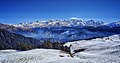
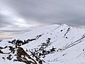
In spring, there is contrast of greenery of the grasslands and red and pink rhododendrons. [4] During the summer months, local shepherds bring their cattle to graze in the meadow and remain there until the winter season. In winter, the landscape is covered in snow, offering opportunities for trekking and other snow-based activities. The place remains accessible year-round, even during the monsoon season. [5] Views of the Garhwal Himalayas, including Mt. Bandarpunch, Srikantha, Jaonli, Draupadi ka Danda (DKD) and several lesser-known mountains, can be seen from Dayara Bugyal.