Related Research Articles

Newark is the most populous city in the U.S. state of New Jersey, the county seat of Essex County, and a principal city of the New York metropolitan area. As of the 2020 census, the city's population was 311,549. The Population Estimates Program calculated a population of 304,960 for 2023, making it the 66th-most populous municipality in the nation.

Route 27 is a state highway in New Jersey, United States. It runs 38.5 mi (61.96 km) from US 206 in Princeton, Mercer County, northeast to an interchange with McCarter Highway and Broad Street in Newark, Essex County. The route passes through many communities along the way, including New Brunswick, Highland Park, Edison, Metuchen, Rahway, and Elizabeth. Route 27 is a two- to four-lane undivided highway for most of its length, passing through a variety of urban and suburban environments. It intersects and interchanges many roads along the way, including Route 18 in New Brunswick, I-287 in Edison, the Garden State Parkway in Woodbridge, Route 35 in Rahway, Route 28 in Elizabeth, and U.S. Route 22 in Newark. Route 27 crosses the Raritan River on the Albany Street Bridge, which connects Highland Park on the east with New Brunswick on the west.

Route 21 is a state highway in Northern New Jersey, running 14.35 mi (23.09 km) from the Newark Airport Interchange with US 1-9 and US 22 in Newark, Essex County to an interchange with US 46 in Clifton, Passaic County. The route is a four- to six-lane divided highway known as McCarter Highway on its southern portion in Newark that serves as a connector between the Newark and Paterson areas, following the west bank of the Passaic River for much of its length. It also serves as the main north–south highway through the central part of Newark, connecting attractions in Downtown Newark with Newark Airport. The portion of Route 21 through Newark is a surface arterial that runs alongside the elevated Northeast Corridor rail line through the southern part of the city and continues north through Downtown Newark while the portion north of Downtown Newark is a freeway. Route 21 intersects many major roads including I-78, Route 27, and I-280 in Newark, Route 7 in Belleville, and Route 3 in Clifton.

Essex County is located in the northeastern part of the U.S. state of New Jersey, and is one of the centrally located counties in the New York metropolitan area. As of the 2020 census, the county was the state's second-most populous county, with a population of 863,728, its highest decennial count since the 1970 census and an increase of 79,759 (+10.2%) from the 2010 census count of 783,969. The county is part of the North Jersey region of the state.

Newark Liberty International Airport is a major international airport serving the New York metropolitan area. The airport straddles the boundary between the cities of Newark in Essex County and Elizabeth in Union County, in the U.S. state of New Jersey. Located approximately 4.5 miles (7.2 km) south of downtown Newark and 9 miles (14 km) west-southwest of Manhattan, it is a major gateway to destinations in Europe, South America, Asia, and Oceania. It is jointly owned by the two cities, and the airport itself is leased to its operator, the Port Authority of New York and New Jersey. It is the second-busiest airport in the New York airport system behind John F. Kennedy International Airport and ahead of LaGuardia Airport.

The Port Authority Trans-Hudson (PATH) is a 13.8-mile (22.2 km) rapid transit system in the northeastern New Jersey cities of Newark, Harrison, Jersey City, and Hoboken, as well as Lower and Midtown Manhattan in New York City. It is operated as a wholly owned subsidiary of the Port Authority of New York and New Jersey. PATH trains run around the clock year-round; four routes serving 13 stations operate during the daytime on weekdays, while two routes operate during weekends, late nights, and holidays. It crosses the Hudson River through cast iron tunnels that rest on a bed of silt on the river bottom. It operates as a deep-level subway in Manhattan and the Jersey City/Hoboken riverfront; from Grove Street in Jersey City to Newark, trains run in open cuts, at grade level, and on elevated track. In 2023, the system saw 55,109,100 rides, or about 185,600 per weekday in the second quarter of 2024, making it the fifth-busiest rapid transit system in the United States.

New Jersey Transit Corporation, branded as NJ Transit or NJTransit and often shortened to NJT, is a state-owned public transportation system that serves the U.S. state of New Jersey and portions of the states of New York and Pennsylvania. It operates buses, light rail, and commuter rail services throughout the state, connecting to major commercial and employment centers both within the state and in its two adjacent major cities, New York City and Philadelphia. In 2023, the system had a ridership of 209,259,800.

The Northeast Corridor Line is a commuter rail service operated by NJ Transit between the Trenton Transit Center and New York Penn Station on Amtrak's Northeast Corridor in the United States. The service is the successor to Pennsylvania Railroad commuter trains between Trenton and New York, and is NJ Transit's busiest commuter rail service. After arrival at New York Penn Station, some trains load passengers and return to New Jersey, while others continue east to Sunnyside Yard for storage. Most servicing is done at the Morrisville Yard, at the west end of the line.
Newark Penn Station is an intermodal passenger station in Newark, New Jersey. One of the New York metropolitan area's major transportation hubs, Newark Penn Station is served by multiple rail and bus carriers, making it the seventh busiest rail station in the United States, and the fourth busiest in the New York City metropolitan area.

Newark Liberty International Airport Station is a railroad hub on the Northeast Corridor (NEC) in Newark, New Jersey. The station provides access to Newark Liberty International Airport (EWR) via the AirTrain Newark monorail which connects the station to the airport's terminals and parking areas. The station is served by New Jersey Transit's (NJT) Northeast Corridor Line and North Jersey Coast Line and Amtrak's Northeast Regional and Keystone Service trains.
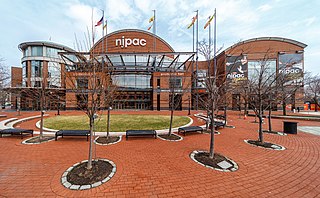
The New Jersey Performing Arts Center (NJPAC), in Downtown Newark in Newark, New Jersey, is one of the largest performing arts centers in the United States. Home to the New Jersey Symphony Orchestra (NJSO), more than nine million visitors have visited the center since it opened in October 1997 on the site of the former Military Park Hotel.

Weequahic Park is a park located in the South Ward of Newark, New Jersey, USA, designed by the Olmsted Brothers firm,. The park is 311.33 acres including an 80-acre (320,000 m2) lake. The Weequahic Park Historic District was added to the National Register of Historic Places on February 12, 2003, for its significance in architecture, community planning, and landscape architecture.

Newark–World Trade Center is a rapid transit service operated by the Port Authority Trans-Hudson (PATH). It is colored red on the PATH service map and trains on this service display red marker lights. This service operates from Pennsylvania Station in Newark, New Jersey, by way of the Downtown Hudson Tubes to the World Trade Center in Lower Manhattan, New York City, New York. Operating 24 hours a day, the 8.9-mile (14.3 km) trip takes 22+1⁄2 minutes to complete.

The Newark–Elizabeth Rail Link (NERL) is a New Jersey Transit proposed 8.8-mile (14.2 km)-long light rail line in New Jersey, which would connect the downtown areas of Newark and Elizabeth with Newark Liberty International Airport. The construction of the project was being planned in stages, or "minimum operable segments" (MOS).

The Gateway Region is the primary urbanized area of the northeastern section of New Jersey. It is anchored by Newark, the state's most populous city. It is part of the New York metropolitan area.

Transportation in New Jersey utilizes a combination of road, rail, air, and water modes. New Jersey is situated between Philadelphia and New York City, two major metropolitan centers of the Boston-Washington megalopolis, making it a regional corridor for transportation. As a result, New Jersey's freeways carry high volumes of interstate traffic and products. The main thoroughfare for long distance travel is the New Jersey Turnpike, the nation's fifth-busiest toll road. The Garden State Parkway connects the state's densely populated north to its southern shore region. New Jersey has the 4th smallest area of U.S. states, but its population density of 1,196 persons per sq. mi causes congestion to be a major issue for motorists.

Dock Bridge is a pair of vertical lift bridges crossing the Passaic River at Newark, Essex County and Harrison, Hudson County, New Jersey, United States, used exclusively for railroad traffic. It is the seventh crossing from the river's mouth at Newark Bay and is 5.0 miles (8.0 km) upstream from it. Also known as the Amtrak Dock Vertical Lift, it carries Amtrak, NJ Transit, and PATH trains. It is listed on the state and federal registers of historic places.

Weequahic is a neighborhood in the city of Newark in Essex County, in the U.S. state of New Jersey. Part of the South Ward, it is separated from Clinton Hill by Hawthorne Avenue on the north, and bordered by the township of Irvington on the west, Newark Liberty International Airport and Dayton on the east, and Hillside Township and the city of Elizabeth on the south. There are many well maintained homes and streets. Part of the Weequahic neighborhood has been designated a historic district; major streets are Lyons Avenue, Bergen Street, and Chancellor Avenue. Newark Beth Israel Medical Center is a major long-time institution in the neighborhood.
Weequahic Golf Course is an 18-hole public course located in the Dayton neighborhood of Newark, New Jersey.
Lionsgate Newark Studios is a 350,000 square foot film and television production studio under construction in Newark, New Jersey. It is located in Dayton in the South Ward on 15 acres (6.1 ha) of land overlooking Weequahic Golf Course west of Newark Liberty International Airport.
References
- ↑ East Ward, Newark Archived June 27, 2014, at the Wayback Machine
- ↑ "Dayton neighborhood in Newark, New Jersey (NJ), 07114, 07112 subdivision profile - real estate, apartments, condos, homes, community, population, jobs, income, streets". www.City-Data.com. Retrieved November 8, 2017.
- ↑ "Weequahic Park". Last-Exit.net. Archived from the original on February 26, 2006. Retrieved November 8, 2017.
- ↑ Dayton Street Newark Housing Authority [ permanent dead link ][1].pdf
- ↑ "PANYNJ Board approves $160 million for EWR Station Access project". Mass Transit. March 28, 2024.
- ↑ Fazelpoor, Matthew (March 26, 2024). "$160M project aims to transform transit, airport access for Newark, Elizabeth".
- ↑ "Port Authority backtracks, says South Ward station still in PATH plans". NJ.com. January 19, 2017. Retrieved November 8, 2017.
- ↑ "What's the Plan for PATH Service to Newark Liberty Airport? - NJ Spotlight". www.NJSpotlight.com. Retrieved November 8, 2017.
- ↑ "PATH Expansion Would Provide Direct Access Between Newark Airport and Manhattan". January 27, 2017.
- ↑ Tully, Tracey (May 17, 2022). "$100 Million Film Studio to Rise from Rubble of Ex-Public Housing Site". The New York Times.
- ↑ "Lionsgate, Great Point Partner for Major New Jersey Studio Complex". May 17, 2022.
- ↑ "Hollywood on Newark Bay? Officials say Lionsgate film & TV studio is coming to Brick City". Nj. May 17, 2022.