
Peque is a municipality in the Colombian department of Antioquia.
Karagümrük is a neighborhood in Fatih district of Istanbul, Turkey. The neighborhood is home to Turkish Superleague soccer team Karagümrük Spor Kulübü. In 1958, the team qualified for the first division, but was eventually relegated to the Third Division.

Lozice is a small village in the Pardubice Region of the Czech Republic. It has around 160 inhabitants.

This is a list of the extreme points of Azerbaijan, the points that are farther north, south, east or west than any other location.
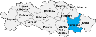
Nižné Ladičkovce is a village and municipality in Humenné District in the Prešov Region of north-east Slovakia.

San Felices is a municipality located in the province of Soria, Castile and León, Spain. According to the 2004 census (INE), the municipality has a population of 81 inhabitants.
Villanueva de San Mancio is a municipality located in the province of Valladolid, Castile and León, Spain. According to the 2004 census (INE), the municipality has a population of 125 inhabitants.
Prödel is a former municipality in the Jerichower Land district, in Saxony-Anhalt, Germany. Since 1 January 2008, it is part of the town Gommern.

Rona de Jos is a commune in Maramureș County, Romania. It is composed of a single village, Rona de Jos.

Gendərə is a village in the Ismailli Rayon of Azerbaijan.

Graniczna is a village in the administrative district of Gmina Józefów nad Wisłą, within Opole Lubelskie County, Lublin Voivodeship, in eastern Poland. It lies approximately 16 kilometres (10 mi) south of Opole Lubelskie and 53 km (33 mi) south-west of the regional capital Lublin.
Yeni Novruzlu is a village and municipality in the Saatly Rayon of Azerbaijan. It has a population of 881.
Axtaçı Muğan is a village and municipality in the Sabirabad Rayon of Azerbaijan. It has a population of 1,914.
Zbęchy is a village in the administrative district of Gmina Krzywiń, within Kościan County, Greater Poland Voivodeship, in west-central Poland. It lies approximately 9 kilometres (6 mi) north-east of Krzywiń, 20 km (12 mi) east of Kościan, and 43 km (27 mi) south of the regional capital Poznań.

Xuân La is a rural commune (xã) of Pác Nặm District, Bắc Kạn Province, in Vietnam.

San Miguel Amatitlán is a town and municipality in Oaxaca in south-western Mexico. The municipality covers an area of 198.48 km². It is part of the Huajuapan District in the north of the Mixteca Region.

Uukwiyu Constituency is an electoral constituency in the Oshana Region of Namibia. It has 11,894 inhabitants, its district capital is the settlement of Uukwiyu.

Vinarce is a town in the municipality of Leskovac, Serbia. According to the 2002 census, the town has a population of 3090 people.
Dositeevo is a village in the municipality of Harmanli, in Haskovo Province, in southern Bulgaria.

Nemiroğlu is a village in Tarsus district of Mersin Province, Turkey. It is situated at 36°55′N35°01′E in Çukurova to the east of Tarsus and to the south of the Turkish state highwat . Its distance to Tarsus is 15 kilometres (9.3 mi) and to Mersin is 40 kilometres (25 mi). The population of Nemiroğlu was 119 as of 2012. Main economic activity is agriculture and grapes is the major crop of the village.


