Adah is an unincorporated community in German Township, Fayette County in the U.S. state of Pennsylvania. It is known as a patch town as it was created to support a coal mine. Adah is the home of the Palmer Mine, one of Henry Clay Frick's holdings. It is also the birthplace of boxer Tommy Karpency, a contender in the light heavyweight division.
Larraun in Basque, Larráun in Spanish, is a town and municipality located in the province and autonomous community of Navarre, northern Spain.
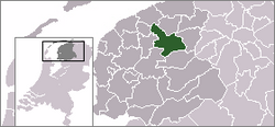
Suwâld is a village in Tytsjerksteradiel municipality in the province of Friesland, the Netherlands. It had a population of around 652 in January 2017.
The canton of Briançon-2 is an administrative division in southeastern France. It consists of the eastern part of the commune of Briançon and its northeastern suburbs. It includes the following communes:
Komorowo is a village in the administrative district of Gmina Bartniczka, within Brodnica County, Kuyavian-Pomeranian Voivodeship, in north-central Poland.

Zamrzenica is a village in the administrative district of Gmina Lubiewo, within Tuchola County, Kuyavian-Pomeranian Voivodeship, in north-central Poland. It lies approximately 9 kilometres (6 mi) west of Lubiewo, 15 km (9 mi) south of Tuchola, and 40 km (25 mi) north of Bydgoszcz.
Załuże is a village in the administrative district of Gmina Lubaczów, within Lubaczów County, Subcarpathian Voivodeship, in south-eastern Poland, close to the border with Ukraine. It lies approximately 5 kilometres (3 mi) north-east of Lubaczów and 85 km (53 mi) east of the regional capital Rzeszów.
Widok is a village in the administrative district of Gmina Chynów, within Grójec County, Masovian Voivodeship, in east-central Poland. It lies approximately 2 kilometres (1 mi) south-east of Chynów, 17 km (11 mi) east of Grójec, and 37 km (23 mi) south of Warsaw.
Barcikowo is a village in the administrative district of Gmina Słupno, within Płock County, Masovian Voivodeship, in east-central Poland. It lies approximately 14 kilometres (9 mi) east of Płock and 82 km (51 mi) north-west of Warsaw.
Grzybowski Młyn is a settlement in the administrative district of Gmina Kościerzyna, within Kościerzyna County, Pomeranian Voivodeship, in northern Poland. It lies approximately 8 kilometres (5 mi) south-west of Kościerzyna and 59 km (37 mi) south-west of the regional capital Gdańsk.
Loryniec is a village in the administrative district of Gmina Kościerzyna, within Kościerzyna County, Pomeranian Voivodeship, in northern Poland.
Łążek is a village in the administrative district of Gmina Kaliska, within Starogard County, Pomeranian Voivodeship, in northern Poland. It lies approximately 4 kilometres (2 mi) east of Kaliska, 19 km (12 mi) south-west of Starogard Gdański, and 58 km (36 mi) south-west of the regional capital Gdańsk.
Mechowo is a village in the administrative district of Gmina Golczewo, within Kamień County, West Pomeranian Voivodeship, in north-western Poland. It lies approximately 9 kilometres (6 mi) north of Golczewo, 18 km (11 mi) south-east of Kamień Pomorski, and 61 km (38 mi) north-east of the regional capital Szczecin.

Grønsalen or Grønjægers Høj is located near Fanefjord Church on the Danish island of Møn. Some 100 metres long and 10 metres wide, it is Denmark's largest long barrow and is widely recognised as one of Europe's outstanding ancient monuments.
Naccache is a suburban area located on the northern edge of Beirut, Lebanon. "It is located on Mount Lebanon and is administered by the municipality of Antelias. It also the headquarters of Murr Television and Studio.

Zabieliai Palace is a former residential palace in Kaunas Old Town, at the corner of T.Daugirdo street and Kaunas Town Hall square. Currently it is occupied by restaurant "Medžiotojų užeiga".
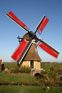
The Ouddeelsmolen, Lytse Geast or Swarte Prinsch is a smock mill in Tytsjerk, Friesland, Netherlands which was built in 1900 and has been converted to a holiday cottage. Restored so that it can turn in the wind, it is listed as a Rijksmonument.
Tobar is an extinct town in Elko County, in the U.S. state of Nevada.