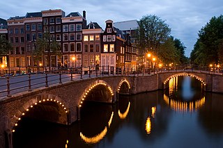
Amsterdam is the capital and most populous city of the Netherlands; with a population of 905,234 within the city proper, 1,558,755 in the urban area and 2,480,394 in the metropolitan area. Found within the Dutch province of North Holland, Amsterdam is colloquially referred to as the "Venice of the North", due to the large number of canals which form a UNESCO World Heritage Site.

Schiedam is a city and municipality in the west of the Netherlands. It is located in the Rotterdam–The Hague metropolitan area, west of Rotterdam, east of Vlaardingen, and south of Delft. In the south the city is connected with the village of Pernis by the Beneluxtunnel.

Gouda is a city and municipality in the west of the Netherlands, between Rotterdam and Utrecht, in the province of South Holland. Gouda has a population of 72,338 and is famous for its Gouda cheese, stroopwafels, many grachten, smoking pipes, and its 15th-century city hall. Its array of historic churches and other buildings makes it a very popular day trip destination.

Delfzijl is a city and former municipality with a population of 25,651 in the province of Groningen in the northeast of the Netherlands. Delfzijl was a sluice between the Delf and the Ems, which became fortified settlement in the 16th century. The fortifications were removed in the late 19th century. Delfzijl is the fifth largest seaport in the Netherlands, and the largest port in the North East of the country.

Sneek is a city southwest of Leeuwarden and seat of the former municipality of Sneek in the province of Friesland, the Netherlands. As of 2011 it is part of the municipality Súdwest-Fryslân. The city had approximately 33,855 inhabitants in January 2017.

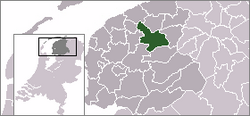
Tytsjerksteradiel is a municipality in the province of Friesland in the Netherlands. It is named after the town of Tytsjerk, whose name is derived from a person named Tiete. Tiete was a daughter of Tryn, after whom the region (Trynwâlden) is named. The other villages in Trynwâlden are also named after Tryn's children: Oentsjerk (Oene), Gytsjerk (Giete), Readtsjerk (Reade), Aldtsjerk (Âlde), Ryptsjerk (Rype). A statue of Tryn and her children is placed in Oentsjerk next to the mainroad (Rengerswei). Tsjerk is the West Frisian word for Church. Until 1989 the official name of the municipality was Tietjerksteradeel, the Dutch name; the current official name is West Frisian. The largest village in the municipality is Burgum.

Noordwijk is a town and municipality in the west of the Netherlands, in the province of South Holland. The municipality covers an area of 74.94 km2 (28.93 sq mi) of which 16.57 km2 (6.40 sq mi) is water and had a population of 42,859 in 2019.

Aldtsjerk is a village on the main road from Leeuwarden to Dokkum. It is part of Tytsjerksteradiel municipality, Friesland, the Netherlands and had around 615 inhabitants as of January 2018.

Ringsend is a southside inner suburb of Dublin, Ireland. It is located on the south bank of the River Liffey and east of the River Dodder, about two kilometres east of the city centre. It is the southern terminus of the East Link Toll Bridge. Areas included in Ringsend are the south side of the Dublin Docklands, and at the west end is the area of South Lotts and part of the Grand Canal Dock area. Neighbouring areas include Irishtown, Sandymount and the Beggars Bush part of Ballsbridge to the south, and the city centre to the west. A key feature of the area is the chimneys of Poolbeg power station.

Burgum is the largest and administrative town of the municipality of Tytsjerksteradiel, in the Dutch province of Friesland. It had a population of 10,058 inhabitants in January 2017.

Bergentheim is a village in the municipality of Hardenberg, the Netherlands. Located between the canal Almelo- De Haandrik and the railway Zwolle-Emmen, the town used to have a railway station, but it was closed in 1975. The building was still there until August 1993.
Creil is one of the ten so-called green villages (Dutch: groendorpen) in the Dutch province of Flevoland. It is a part of the municipality of Noordoostpolder, and lies about 6 km northwest of Emmeloord.
Espel is one of the so-called green villages (Dutch: groendorpen) in the Dutch province of Flevoland. It lies in the municipality of Noordoostpolder next to a crossroads where provincial road N712 from Urk to Lemmer intersects with road N714 to Emmeloord, roughly 6 km to the east.

Cholmondeston is a village and civil parish in the unitary authority of Cheshire East and the ceremonial county of Cheshire, England. The village lies 5 miles (8 km) to the northwest of Nantwich. Nearby villages include Aston juxta Mondrum, Barbridge, Calveley and Wettenhall. The Middlewich Branch of the Shropshire Union Canal and the Crewe–Chester railway line run through the civil parish. The area is predominantly rural, with a total population of around 150 in 2001, increasing to 175 at the 2011 Census.

Eastermar is a village in Tytsjerksteradiel municipality in the province Friesland of the Netherlands. It had around 1,575 citizens in January 2017.
Mûnein is a village in Tytsjerksteradiel municipality in the province Friesland of the Netherlands. It had a population of around 580 in 2018.
Skûlenboarch is a hamlet in Tytsjerksteradiel in the province Friesland of the Netherlands. The hamlet lies south of Jistrum, every house north of Princess Margriet Canal falls officially under Jistrum. The houses south of the canal are officially part of Eastermar. A bridge connects the two halves of Skûlenboarch with each other. The Joost Wiersmawei(road) connects the hamlet with Jistrum and a cycling path connects the yacht harbour with Skûlenboarch.

Heeg is a village in Súdwest Fryslân municipality in the province Friesland of the Netherlands and had a population of around 2,175 in January 2017.

Godsheide is Flemish-speaking hamlet and Catholic parish within the northeastern corner of the Belgian city of Hasselt, in the province of Limburg. At the end of 2007 Godsheide counted 3,143 inhabitants.
Kûkherne is a hamlet in the municipalities of Achtkarspelen, Dantumadiel and Tytsjerksteradiel, in the province of Friesland, the Netherlands.