Hurdegaryp

Last updated
Hurdegaryp
Hardegarijp
Village
Hurdegaryp, de Hofkerk RM35655 foto3 2015-05-10 10.59.jpg
Hurdegaryp, church (de Hofkerk)
Hardegarijp vlag.svg
Hurdegaryp wapen.svg
Map NL Tytsjerksteradiel Hurdegaryp.png
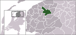
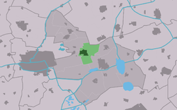
Location of the village in Tytsjerksteradiel
2010-NL-P02-Fryslan-positiekaart-gemnamen.jpg
Red pog.svg
Hurdegaryp
Location in the Netherlands
Netherlands location map.svg
Red pog.svg
Hurdegaryp
Hurdegaryp (Netherlands)
Coordinates: 53°12′54″N5°56′25″E / 53.21500°N 5.94028°E / 53.21500; 5.94028
Country Flag of the Netherlands.svg Netherlands
Province Frisian flag.svg Friesland
Municipality Tytsjerksteradiel flag.svg Tytsjerksteradiel
Area
[1]
  Total
10.58 km2 (4.08 sq mi)
Elevation
[2]
0.7 m (2.3 ft)
Population
 (2021) [1]
  Total
4,995
  Density470/km2 (1,200/sq mi)
Postal code
9254 [1]
Dialing code 0511

Hurdegaryp (Dutch : Hardegarijp [3] ) is a village in the northern part of the Netherlands, in the municipality of Tytsjerksteradiel. Its history dates back to at least the 13th century. It had a population of around 4,788 in January 2017. [4]

Contents

In Dutch the village is called Hardegarijp, Hurdegaryp is its West Frisian and official name.

History

The village was first mentioned in 1401 as Herdegaryp. The etymology is unclear. [5] Originally the centre of the village was located further south. In 1830, the road to Leeuwarden was built. The Hurdegaryp railway station followed in 1866, and the centre of the village moved towards to the road and station. [5] [6]

The Dutch Reformed church was built in 1711 and has a wooden tower. It was a replacement for a 13th century church. [7] Up to 1829, the Grovestins, a fortified tower was located to the south of the village. [7]

Hurdegaryp was home to 624 people in 1840, [8] but its population has grown to around five thousand as of 2021. [1] In 2017, five tiny houses measuring 3 by 9 metres were built in Hurdegaryp as affordable houses at €50,000.- It was an initiative of a starting real estate agent who himself could not afford to exchange his rented student room with a house. They were immediately sold. [9]

Transportation

See also

References

  1. 1 2 3 4 "Kerncijfers wijken en buurten 2021". Central Bureau of Statistics. Retrieved 5 April 2022.
  2. "Postcodetool for 9254AA". Actueel Hoogtebestand Nederland (in Dutch). Het Waterschapshuis. Archived from the original on 21 September 2013. Retrieved 5 April 2022.
  3. Taalunie (2019). "Friese namen" (in Dutch). Retrieved 18 November 2019.
  4. Overzicht inwonersaantal Tytsjerksteradiel - Tytsjerksteradiel
  5. 1 2 "Hurdegaryp - (geografische naam)". Etymologiebank (in Dutch). Retrieved 5 April 2022.
  6. Ronald Stenvert & Sabine Broekhoven (2000). "Hurdegaryp" (in Dutch). Zwolle: Waanders. ISBN   90 400 9476 4 . Retrieved 5 April 2022.
  7. 1 2 "Hurdegaryp". Friesland Wonderland (in Dutch). Retrieved 5 April 2022.
  8. "Hurdegaryp" (in Dutch). Retrieved 5 April 2022.
  9. "Direct belangstelling voor vijf 'tiny houses'". Leeuwarder Courant (in Dutch). Retrieved 5 April 2022.