
Eel Pie Island is an 8.935-acre (3.6 ha) island in the River Thames at Twickenham in the London Borough of Richmond upon Thames. It is on the maintained minimum head of water above the only lock on the Tideway and is accessible by boat or from the left bank by footbridge. The island had a club that was a major venue for jazz and blues in the 1960s.

Teddington Lock is a complex of three locks and a weir on the River Thames between Ham and Teddington in the London Borough of Richmond upon Thames, England. Historically in Middlesex, it was first built in 1810.
This article lists the islands in the River Thames, or at the mouth of a tributary, in England. It excludes human-made islands built as part of the building of forty-five two-gate locks which each accompany a weir, and islets subordinate to and forming part of the overall shape of another. The suffix -ey is common across England and Scotland and cognate with ait and meaning island, a term – as ait or eyot – unusually well-preserved on the Thames. A small minority of list entries are referred to as Island, Ait or Eyot and are vestiges, separated by a depression in the land or high-water-level gully.

Pipers Island, or Piper's Island, is the third-smallest map-named island in the River Thames, in England. It is on the Reading, Berkshire reach. It is toward the edge of the central urban area of the town of Reading and connected by a gangway to Caversham Bridge, a road and pedestrian bridge that links that town to its left bank suburb of Caversham.

Chiswick Eyot is a 3.266-acre (1.3 ha) narrow, uninhabited ait of the Thames. It is a tree- and reed-covered rise on the Tideway by Chiswick, in London, England and is overlooked by Chiswick Mall and by some of the Barnes riverside on the far bank.

Desborough Island is a 112-acre (0.45 km2) manmade island in the River Thames on the reach above Sunbury Lock in Surrey, England. It was formed in the 1930s by the digging of a channel – the Desborough Cut – by the Thames Conservancy as a meander cutoff of narrow width on the right bank. The island and cut are named after Lord Desborough, a chairman of the Thames Conservancy.

Glover's Island is in a tree-lined section of river, formerly known as Horse Reach on the tidal Thames, between Richmond Lock and Teddington Lock in the Borough of Richmond upon Thames, London, England.

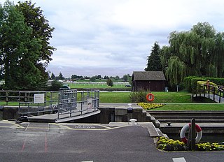
Sunbury Lock is a lock complex of the River Thames in England near Walton-on-Thames in north-west Surrey, the third lowest of forty four on the non-tidal reaches. The complex adjoins the right, southern bank about 1⁄2 mile (0.80 km) downstream of the Weir Hotel.

Old Windsor Lock is a lock on the River Thames in England on the right bank beside Old Windsor, Berkshire. The lock marks the downstream end of the New Cut, a meander cutoff built in 1822 by the Thames Navigation Commissioners which created Ham Island. The lock and a wider footbridge give access to the island. Two weirs are associated; the smaller adjoins and the larger is upstream. The lock is the ninth lowest of the forty-five on the river.

Romney Lock is a lock on the River Thames in England near Windsor and Eton, about half a mile downstream of Windsor Bridge. It is on the Windsor side of the river next to a boatyard and adjoins Romney Island, a long strip-shaped ait in the middle of the river. The first lock was built by the Thames Navigation Commission in 1798.
Boveney Lock is a lock on the River Thames situated on the Buckinghamshire bank opposite the Windsor Racecourse and close to Eton Wick. Boveney is a village a little way upstream on the same side. The lock was first built in 1838 by the Thames Navigation Commission. The lock was rebuilt in 1898 closer to the Buckinghamshire bank, and a set of boat rollers were installed on the old site.

St John's Bridge is a two-section road bridge across the channel of the upper Thames near Lechlade, England, then across the lock cut to the south, the highest lock on the Thames. It is a Grade II listed building.

Tagg's Island, in the London Borough of Richmond upon Thames, is an island on the River Thames on the reach above Molesey Lock and just above Ash Island.

Hollyhock Island is an inhabited island in the River Thames in England on the reach between Bell Weir Lock and Penton Hook Lock.

Swan Island is a private mooring island in the Thames at Twickenham, in the London Borough of Richmond upon Thames, London, England. It is on the Tideway about 3⁄4 mile (1.2 km) north of and thus below Teddington Lock.

Brentford Ait is a long 4.572-acre (1.9 ha) uninhabited ait in the River Thames, without buildings, on the Tideway near Brentford in London, England.

Lot's Ait is a 1.724-acre (0.7 ha) ait in the Thames. It is on the Tideway near Brentford, in the London Borough of Hounslow, England.

Isleworth Ait, also known as Isleworth Eyot, is a between 3.5-hectare (8.6-acre) and 9.370-acre (3.792 ha) teardrop-shaped island in the River Thames in England. The long ait is on the Tideway facing Old Isleworth and the towpath alongside the Royal Mid-Surrey Golf Club. These places are in the London Boroughs of Hounslow and Richmond upon Thames. The island faces Heron's Place and a number of commercial buildings.

Benn's Island, previously named Church Eyot, Kember's Eyot and sometimes referred to as Benn's Ait, is a private 0.1-acre (0.040 ha) ait (island) on the River Thames south-west of London. It is among a string of narrow islands above Molesey Lock and due to its clubhouse and size — the second-smallest named island on the Thames — it has deep foundation pilings to raise the building more than 1 m above the water line.
The Unnamed Eyot is an island in the River Thames in Berkshire, England, north of the village of Wargrave, Berkshire, its parish in civil terms and ecclesiastical parish in the Church of England. It is on the reach above Marsh Lock.

