Romney Lock

Last updated

Romney Lock
RomneyLock01.JPG
Romney Lock from downstream
Waterway River Thames
County Berkshire
Maintained by Environment Agency
OperationHydraulic
First built1798
Latest built1980
Length78.50 m (257 ft 7 in) [1]
Width7.45 m (24 ft 5 in) [1]
Fall2.01 m (6 ft 7 in) [1]
Above sea level60 feet (18 m)
Distance to
Teddington Lock
23 miles (37 km)
Power is available out of hours
Romney Lock
BSicon uSTR.svg
River Thames
BSicon uSTR+l.svg
BSicon uSTRq.svg
BSicon uSTRq.svg
BSicon uFABZgr+r.svg
Clewer Mill Stream
BSicon uSTR.svg
BSicon uSTR+l.svg
BSicon uSTRq.svg
BSicon uFABZgr+r.svg
BSicon uSTR.svg
BSicon uSTR.svg
BSicon uSTR+l.svg
BSicon uABZgr.svg
BSicon uSTR.svg
BSicon uxWEIRg.svg
BSicon uPLANEu.svg
BSicon uFGATEu.svg
Boveney Lock
(and boat rollers)
BSicon uSTR.svg
BSicon uSTR.svg
BSicon uSTRl.svg
BSicon uABZg+r.svg
BSicon uSTR.svg
BSicon uSTRl.svg
BSicon uSTRq.svg
BSicon uFABZgr+r.svg
BSicon ueABZgl.svg
BSicon uexSTR+r.svg
BSicon uSTR.svg
BSicon uddSTRl.svg
BSicon uexSTR.svg
BSicon uSTR.svg
Race Course Yacht Basin
BSicon ueMILL.svg
BSicon uSTR+l.svg
BSicon uxABZgr.svg
Site of old mill
BSicon uSTRl.svg
BSicon uFABZgr+r.svg
BSicon uxWEIRg.svg
Cuckoo Weir
BSicon uSKRZ-Au.svg
BSicon uexSKRZ-Au.svg
A332 Queen Elizabeth Bridge
BSicon ueABZg+l.svg
BSicon uexSTRr.svg
-- (Windsor & Eton Bypass)
BSicon uSTR+l.svg
BSicon uFABZgr+r.svg
BSicon umKRZu.svg
BSicon umKRZu.svg
Windsor Railway Bridge
BSicon uSTRl.svg
BSicon uFABZgr+r.svg
Baths Island
BSicon uxISLAND.svg
Deadwater Ait
BSicon uISLAND.svg
Firework Ait
BSicon uSKRZ-Eu.svg
Windsor Bridge
BSicon uSTR+l.svg
BSicon uSTRr.svg
BSicon uABZgl.svg
BSicon ueABZq+r.svg
BSicon uSTR+r.svg
BSicon uSTR.svg
BSicon uxWEIRg.svg
BSicon uddSTRr.svg
moorings
BSicon uSTR.svg
BSicon uexSTR.svg
BSicon ueMILL.svg
Site of old mill
BSicon uWEIRr.svg
BSicon uexABZg+r.svg
BSicon uexSTR.svg
weir
BSicon uFGATEu.svg
BSicon uexABZg+l.svg
BSicon uexSTRr.svg
Romney Lock
BSicon uFABZgl+l.svg
BSicon uexFABZgr+r.svg
BSicon uexSTR+l.svg
Jubilee River
BSicon uSTR.svg
BSicon uexSTR.svg
BSicon uxWEIRg.svg
-- (from Boulter's Lock)
BSicon umKRZu.svg
BSicon uxmKRZu.svg
BSicon uxmKRZu.svg
Black Potts Railway Bridge
BSicon ueABZg+l.svg
BSicon uexSTRr.svg
BSicon uexSTR.svg
BSicon ueABZg+l.svg
BSicon uexSTRq.svg
BSicon uexSTRr.svg
BSicon uSTR.svg
River Thames

Romney Lock is a lock on the River Thames in England near Windsor and Eton, about half a mile downstream of Windsor Bridge. It is on the Windsor side of the river next to a boatyard and adjoins Romney Island, a long strip-shaped ait in the middle of the river. The first lock was built by the Thames Navigation Commission in 1798.

Contents

The weir is some distance upstream near the end of Romney Island and runs across the river to Cutlers Ait. A small 200kW hydroelectric generation station was installed in 2011 to supply electricity to Windsor Castle. [2] [3]

History

The first proposal for a pound lock was in 1774 which was to be further upstream at Firework Ait by Windsor Bridge. However nothing happened until the lock was opened on the present site in 1797, built of oak. There was no weir at the site previously and because of protests, none was built at that time. Barges were still liable to pay the lock fee even if they used the other channel. By the following year a weir was found to be indispensable, and so it was built. The lock was rebuilt by the Thames Conservancy in 1869 and the weir was rebuilt further upstream at the beginning of the 20th century. [4] The lock was rebuilt again in 1979/80.

Access to the lock

The lock can be reached from Windsor down a long single track road which starts from the car park behind Windsor and Eton Riverside railway station.

Reach above the lock

Windsor from the river RomneyWindsor01.JPG
Windsor from the river

Eton College is on the left bank, beyond Cutler's Ait immediately upstream of which is the compact town Eton itself where Windsor Bridge crosses. On the Windsor bank the river skirts the town centre and set close to it upstream of Windsor Bridge is an islet, the smallest named on the Thames, Firework Ait and similarly Deadwater Ait. Just upstream of the islets are the Isambard Kingdom Brunel-designed Windsor Railway Bridge for the second railway serving the town which crosses Baths Island, and the late 20th century road bridge Queen Elizabeth Bridge. Cuckoo Weir Stream is a short backwater taking a left bank route under Queen Elizabeth Bridge on the right bank associated with Clewer is the confluence of the Clewer Mill Stream. The main river then has a sharp Z-bend near Windsor Racecourse, then continues past open fields near the village of Eton Wick before it reaches Boveney Lock. Rowing on the reach has been reduced by the 2006 creation of Dorney Lake in the ancient and modern civil and ecclesiastical parishes Dorney.

Thames Path

The Thames Path follows the track on the south bank to Windsor and then crosses Windsor Bridge to the north (Eton) side, where it continues to Boveney Lock.

The lock looking upstream with Windsor Castle on the horizon RomneyLock02.JPG
The lock looking upstream with Windsor Castle on the horizon
Romney Lock in winter looking upstream Romney Lock.JPG
Romney Lock in winter looking upstream

See also

Next lock upstream River Thames Next lock downstream
Boveney Lock
3.75 km (2.33 mi) [5]
Romney Lock
Grid reference: SU970779
Old Windsor Lock
4.83 km (3.00 mi) [5]

Related Research Articles

<span class="mw-page-title-main">Teddington Lock</span> Series of locks on the River Thames in London

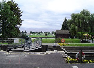
Teddington Lock is a complex of three locks and a weir on the River Thames between Ham and Teddington in the London Borough of Richmond upon Thames, England. Historically in Middlesex, it was first built in 1810.

<span class="mw-page-title-main">Caversham Lock</span> Lock and weir on the River Thames in Berkshire, England

Caversham Lock is a lock and main weir on the River Thames in England at Reading, Berkshire. Both the lock and main weir are connected to De Bohun Island. The Thames Navigation Commissioners built the original lock in 1778. Additional sluices north of View Island and Heron Island form the whole weir complex. A footbridge passes over all three islands to connect Lower Caversham to Reading via a route other than George Street and Reading Bridge.

<span class="mw-page-title-main">Marsh Lock</span> Lock and weir on the River Thames in Berkshire, England

Marsh Lock is a lock and weir situated on the River Thames in England, about 1 mile upstream of Henley Bridge in Henley-on-Thames, Oxfordshire. The lock is close to the Berkshire bank, but accessed from the Oxfordshire side via two long walkways, the downstream one being near Mill Meadows. The first pound lock was built by the Thames Navigation Commission in 1773.

<span class="mw-page-title-main">Sonning Lock</span> Lock and weir on the River Thames in Berkshire, England

Sonning Lock is a lock and associated weir situated on the River Thames at the village of Sonning near Reading, Berkshire, England. The first lock was built by the Thames Navigation Commission in 1773 and it has been rebuilt three times since then. There is a weir a little upstream at the top of the island where Sonning Backwater separates from the main course of the river.

<span class="mw-page-title-main">Bray Lock</span> Lock and weir on the River Thames in Buckinghamshire, England

Bray Lock is a lock and weir on the River Thames in England near Bray and Dorney Reach, and is just above the M4 Bridge across the Thames. The lock is on the Buckinghamshire side of the river on the opposite bank from Bray itself and Maidenhead which are in Berkshire. Here, the county line stands roughly halfway between the lock and the opposite bank, following the course of the Thames itself. The pound lock was built by the Thames Navigation Commission relatively late, in 1845. The lock keeper's cottage is on an island between the lock and the weir.

This article lists the islands in the River Thames, or at the mouth of a tributary, in England. It excludes human-made islands built as part of the building of forty-five two-gate locks which each accompany a weir, and islets subordinate to and forming part of the overall shape of another. The suffix -ey is common across England and Scotland and cognate with ait and meaning island, a term – as ait or eyot – unusually well-preserved on the Thames. A small minority of list entries are referred to as Island, Ait or Eyot and are vestiges, separated by a depression in the land or high-water-level gully.

<span class="mw-page-title-main">Shiplake Lock</span> Lock on the River Thames in Oxfordshire, England

Shiplake Lock is a lock and weir situated on the River Thames in England between the villages of Shiplake and Lower Shiplake, Oxfordshire. It is just above the points where the River Loddon joins the Thames and Shiplake Railway Bridge crosses the river. The first pound lock was built by the Thames Navigation Commission in 1773.

<span class="mw-page-title-main">Eton Wick</span> Human settlement in England

Eton Wick is a village in Berkshire, England, on the River Thames in the civil parish of Eton, close to the historic towns of Windsor and Eton, Slough and Dorney Lake, the rowing venue for the 2012 Summer Olympics.

<span class="mw-page-title-main">Cookham Lock</span> Lock and weirs on the River Thames in Berkshire, England

Cookham Lock is a lock with weirs situated on the River Thames near Cookham, Berkshire, about a half-mile downstream of Cookham Bridge. The lock is set in a lock cut which is one of four streams here and it is surrounded by woods. On one side is Sashes Island and on the other is Mill Island connected to Formosa Island, the largest on the non-tidal Thames.

<span class="mw-page-title-main">Hambleden Lock</span> Lock on the River Thames in Berkshire, England

Hambleden Lock is a lock with a long weir situated on the River Thames in England, about 2 miles downstream of Henley Bridge. The lock is on the Berkshire bank between Aston and Remenham. Built by the Thames Navigation Commission in 1773, the lock is named after the village of Hambleden, a mile (1.5 km) to the north.

<span class="mw-page-title-main">Iffley Lock</span> Lock on the River Thames in Oxfordshire, England

Iffley Lock is a lock on the River Thames in England near the village of Iffley, Oxfordshire. It is on the southern outskirts of Oxford. The original lock was built by the Oxford-Burcot Commission in 1631 and the Thames Navigation Commission replaced this in 1793. The lock has a set of rollers to allow punts and rowing boats to be moved between the water levels.

<span class="mw-page-title-main">Shepperton Lock</span> Lock on the River Thames in Surrey, England

Shepperton Lock is a lock on the River Thames, in England by the left bank at Shepperton, Surrey. It is across the river from Weybridge which is nearby linked by a passenger ferry.

<span class="mw-page-title-main">Molesey Lock</span> Lock on the River Thames in Surrey, England

Molesey Lock is a lock on the River Thames in England at East Molesey, Surrey on the right bank.

<span class="mw-page-title-main">Sunbury Lock</span> Lock on the River Thames in Surrey, England

Sunbury Lock is a lock complex of the River Thames in England near Walton-on-Thames in north-west Surrey, the third lowest of forty four on the non-tidal reaches. The complex adjoins the right, southern bank about 12 mile (0.80 km) downstream of the Weir Hotel.

<span class="mw-page-title-main">Penton Hook Lock</span> Lock on the River Thames in Surrey, England

Penton Hook Lock is the sixth lowest lock of forty four on the non-tidal reaches of the River Thames in England. It faces an island which was until its construction a pronounced meander and is on the site of its seasonal cutoff. It is against the left bank marking the church parish medieval border of Laleham and Staines upon Thames in Surrey for many centuries. Until 1965 their county was Middlesex. At 266 ft (81 m) it is the third longest lock on the river.

<span class="mw-page-title-main">Bell Weir Lock</span> Lock on the River Thames in England

Bell Weir Lock is a lock on the River Thames in England by the right bank, Runnymede which is a water meadow associated with Egham of importance for the constitutional Magna Carta. It is upstream of the terrace of a hotel and the a bridge designed by Edwin Lutyens who designed an ornamental park gate house along the reach. The bridge has been widened and carries the M25 and A30 road across the river in a single span. The lock was first built by the Thames Navigation Commission in 1817; it has one weir which is upstream. The lock is the eighth lowest of forty-five on the river and is named after the founder of the forerunner of the adjoining hotel who took charge of the lock and weir on its construction.

<span class="mw-page-title-main">Old Windsor Lock</span> Lock on the River Thames in Berkshire, England

Old Windsor Lock is a lock on the River Thames in England on the right bank beside Old Windsor, Berkshire. The lock marks the downstream end of the New Cut, a meander cutoff built in 1822 by the Thames Navigation Commissioners which created Ham Island. The lock and a wider footbridge give access to the island. Two weirs are associated; the smaller adjoins and the larger is upstream. The lock is the ninth lowest of the forty-five on the river.

<span class="mw-page-title-main">Boveney Lock</span> Lock on the River Thames in Buckinghamshire, England

Boveney Lock is a lock on the River Thames situated on the Buckinghamshire bank opposite the Windsor Racecourse and close to Eton Wick. Boveney is a village a little way upstream on the same side. The lock was first built in 1838 by the Thames Navigation Commission. The lock was rebuilt in 1898 closer to the Buckinghamshire bank, and a set of boat rollers were installed on the old site.

<span class="mw-page-title-main">Cutlers Ait</span>

Cutlers Ait is an island in the River Thames in England adjacent to Romney Island and Romney Lock, near Windsor, Berkshire.

<span class="mw-page-title-main">Clewer Mill Stream</span> Stream in Berkshire, England

Clewer Mill Stream is a narrow twisting backwater of the River Thames near Windsor, Berkshire, England, which leaves the main river at Bush Ait and rejoins just above Queen Elizabeth Bridge. It is about 1.5 miles long. Clewer Mill Stream is named after the watermill that it once drove.

References

  1. 1 2 3 "Environment Agency Dimensions of locks on the River Thames". web page. Environmental Agency. 8 November 2012. Retrieved 18 November 2012. Dimensions given in metres
  2. Proposals for hydro power scheme
  3. The Queen demonstrates her power Daily Telegraph, 23 November 2013
  4. Fred. S. Thacker The Thames Highway: Volume II Locks and Weirs 1920 - republished 1968 David & Charles
  5. 1 2 "Environment Agency Distances between locks on the River Thames". web page. Environmental Agency. 19 November 2012. Retrieved 21 November 2012. Distances given in km.

Coordinates: 51°29′30″N0°36′15″W / 51.49174°N 0.60422°W / 51.49174; -0.60422