Maidenhead is a market town in the Royal Borough of Windsor and Maidenhead in the county of Berkshire, England, on the southwestern bank of the River Thames. In the 2021 Census, it had an estimated population of 70,374 and forms part of the border with southern Buckinghamshire. The town is situated 27 miles (43 km) west of Charing Cross, London and 13 miles (21 km) east-northeast of the county town of Reading. The town differs from the Parliamentary constituency of Maidenhead, which includes a number of outer suburbs and villages, including villages which form part of the Borough of Wokingham such as Twyford, Charvil, Remenham, Ruscombe and Wargrave.

The Royal Borough of Windsor and Maidenhead is a local government district with royal borough status in Berkshire, England. Its council is a unitary authority, being a district council which also performs the functions of a county council. The borough is named after its two largest towns of Maidenhead and Windsor. The borough also includes the towns of Ascot and Eton, plus numerous villages and surrounding rural areas. It is home to Windsor Castle, Eton College, Legoland Windsor and Ascot Racecourse. It is one of only four boroughs in England entitled to be prefixed royal.

The A4 is a major road in England from Central London to Avonmouth via Heathrow Airport, Reading, Bath and Bristol. It is historically known as the Bath Road with newer sections including the Great West Road and Portway. The road was once the main route from London to Bath, Bristol and the west of England and formed, after the A40, the second main western artery from London.
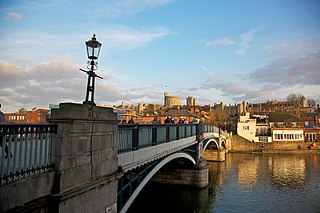
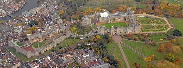
Windsor is a historic town in the Royal Borough of Windsor and Maidenhead in Berkshire, England. It is the site of Windsor Castle, one of the official residences of the British monarch. The town is situated 21.8 miles (35.1 km) west of Charing Cross, central London, 5.8 miles (9.3 km) southeast of Maidenhead, and 15.8 miles (25.4 km) east of the modern county town of Reading. It is immediately south of the River Thames, which forms its boundary with its smaller, ancient twin town of Eton. The village of Old Windsor, just over 2 miles (3 km) to the south, predates what is now called Windsor by around 300 years. In the past, Windsor was formally referred to as New Windsor to distinguish the two.

Eton is a town in Berkshire, England, on the opposite bank of the River Thames to Windsor, connected to it by Windsor Bridge. The civil parish, which also includes the village of Eton Wick two miles west of the town, had a population of 4,692 at the 2011 Census. Within the boundaries of the historic county of Buckinghamshire, in 1974 it came under the administration of Berkshire following the Local Government Act 1972; since 1998 it has been part of the unitary authority of Windsor and Maidenhead. The town is best known as the location of Eton College.

The Jubilee River is a hydraulic channel in southern England. It is 11.6 km (7.2 mi) long and is on average 45 metres wide. It was constructed in the late 1990s and early 2000s to take overflow from the River Thames and so alleviate flooding to areas in and around the towns of Maidenhead, Windsor, and Eton in the counties of Berkshire and Buckinghamshire. It achieves this by taking water from the left bank of the Thames upstream of Boulter's Lock near Maidenhead and returning it via the north bank downstream of Eton. Although successful in its stated aims, residents of villages downstream, such as Wraysbury, claim it has increased flooding in those locations.

Windsor & Eton Central station is one of two terminal stations serving the town of Windsor, Berkshire, England. It is situated on Thames Street, almost immediately opposite Castle Hill, the main public entrance to Windsor Castle. The station is the terminus of a branch line from Slough operated by Great Western Railway.

Windsor & Eton Riverside station is a station in Windsor, Berkshire, England. The station, close to the River Thames and Windsor Castle, is a Grade II listed building. It is 25 miles 48 chains (41.2 km) down the line from London Waterloo and is the terminus of the Staines to Windsor Line, served by South Western Railway.
Kingston Bridge is a road bridge at Kingston upon Thames in south west London, England, carrying the A308 across the River Thames. It joins the town centre of Kingston in the Royal Borough of Kingston upon Thames to Hampton Court Park, Bushy Park, and the village of Hampton Wick in the London Borough of Richmond upon Thames. In 2005 it was carrying approximately 50,000 vehicles per day with up to 2,000 vehicles per hour in each direction during peak times.
Barnes Railway Bridge is a Grade II listed railway bridge in the London Borough of Richmond upon Thames and the London Borough of Hounslow. It crosses the River Thames in London in a northwest to southeast direction at Barnes. It carries the South Western Railway's Hounslow Loop Line, and lies between Barnes Bridge and Chiswick stations. It can also be crossed on foot, and is one of only three bridges in London to combine pedestrian and rail use; the others being Hungerford Bridge and Golden Jubilee Bridges and Fulham Railway Bridge.

The Queen Elizabeth Bridge is a road bridge just to the west of the town of Windsor, Berkshire, England.

Maidenhead Bridge is a Grade I listed bridge carrying the A4 road over the River Thames between Maidenhead, Berkshire and Taplow, Buckinghamshire, England. It crosses the Thames on the reach above Bray Lock, about half a mile below Boulter's Lock. The Thames Path crosses the river here.

Princes Bridge, originally Prince's Bridge, is a bridge in central Melbourne, Australia that spans the Yarra River. It is built on the site of one of the oldest river crossings in the city, and forms a gateway into the central city from the south. The bridge connects Swanston Street on the north bank of the Yarra River to St Kilda Road on the south bank, and carries road, tram and pedestrian traffic. The present bridge was built in 1888 and is listed on the Victorian Heritage Register.

The Staines–Windsor line is a 6 mi 46 ch (10.6 km) railway line in Berkshire and Surrey, England. It branches from the Waterloo–Reading line at Staines-upon-Thames and runs to its western terminus at Windsor via intermediate stations at Wraysbury, Sunnymeads and Datchet. All of the stations are managed by South Western Railway, which operates all passenger trains. Most services run between Windsor & Eton Riverside station and London Waterloo via Richmond and Clapham Junction.

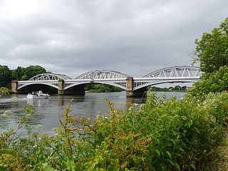
Windsor Railway Bridge is a wrought iron 'bow and string' bridge in Windsor, Berkshire, crossing the River Thames on the reach between Romney Lock and Boveney Lock. It carries the branch line between Slough and Windsor.

Staines Bridge is a road bridge running in a south-west to north-east direction across the River Thames in Surrey. It is on the modern A308 road and links the boroughs of Spelthorne and Runnymede at Staines-upon-Thames and Egham Hythe. The bridge is Grade II listed.
Slough is a town and unitary authority in the English county of Berkshire, just to the west of Greater London. Until 1974 the town was in Buckinghamshire.

Black Potts Railway Bridge carries the railway from London (Waterloo) to Windsor, Berkshire across the River Thames. The Staines to Windsor & Eton Line terminates immediately after the bridge at Windsor and Eton Riverside railway station. The bridge crosses the Thames on the reach above Old Windsor Lock, shortly before Romney Lock.

Datchet Bridge, also known as The Divided Bridge, was a road bridge which crossed the River Thames at Datchet from 1706 until it was demolished in 1848. It was situated on the reach between Old Windsor Lock and Romney Lock and linked Windsor on the Berkshire bank to Datchet on the Buckinghamshire side. The bridge replaced a ferry service which had operated at the site since at least the middle of the 13th century.

The Windsor Castle Act 1848 was an Act of Parliament enacted for the British royal family that reformed land use and rights around Windsor Castle, in Berkshire. The Act's main purpose was to create Home Park. All new roads and bridges were built by 1850. The result turned the former royal estate, which was known as Little Park, into the royal private estate of Home Park.