
Dedza is the main township of Dedza District in the Central Region of Malawi.

The Central Region of Malawi, population 7,523,340 (2018), covers an area of 35,592 km2. Its capital city is Lilongwe, which is also the national capital. The region has an outlet on Lake Malawi and borders neighbouring countries Zambia and Mozambique. The Chewa people make up the majority of the population today.

The Mulanje Massif, also known as Mount Mulanje, is a large inselberg in southern Malawi. Sapitwa Peak, the highest point on the massif at 3,002 m, is the highest point in Malawi. It lies 65 km east of Blantyre, rising sharply from the surrounding plains of Phalombe and the Mulanje district. It forms part of a proposed ecoregion, to be called the South East Africa Montane Archipelago (SEAMA).

The Zomba Plateau, also called the Zomba Massif, is a mountain of the Shire Highlands in southern Malawi. Its total area is about 130 square kilometres (50 sq mi), with a highest point of 2,087 metres (6,847 ft).
Dedza is a district in the Central Region of Malawi. It covers an area of 3,754 km.² to the south of the Malawi capital, Lilongwe, between Mozambique and Lake Malawi and has a population of 830,512. The capital is Dedza.
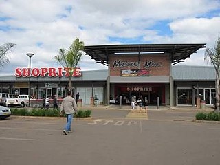
Mzimba is a district in the Northern Region of Malawi. The capital is Mzimba and the biggest town is Mzuzu, which is also the administrative headquarters of the Northern Region. The district covers an area of 10,473 km2 and has a population of 1,017,701 (2023). It is the largest district in Malawi. The district is inhabited by descendants of Tumbuka and few Ngoni people. Tumbuka is the predominant language spoken in the district.
The Viphya Mountains, also known as the Viphya Plateau or Viphya Highlands, are a mountain range in located in Chikangawa in Malawi's Northern Region.
The Kirk Range is a plateau in southwestern Malawi, extending in a north-south direction and skirting the southwestern shore of Lake Malawi and the western border of the Shire River valley. The range includes several peaks higher than 1800 meters in elevation. The northern end of the range overlooks the Central Region plateau and Lake Malawi. The range forms the Malawi-Mozambique border, and the divide between the watersheds of Mozambique's Revúboé River to the west and Malawi's Shire River to the east. The Lisungwe and Mkulumadzi (Wamkulumadzi) rivers are tributaries of the Shire that originate in the Kirk Range.
Mount Soche is a mountain near Blantyre, Malawi.

Mulanje Mountain Forest Reserve is a nature reserve founded in 1927 in Malawi. The reserve covers 56,317 hectares. It is operated by the Mulanje Mountain Conservation Trust. The reserve was designated a biosphere reserve by UNESCO in 2000.
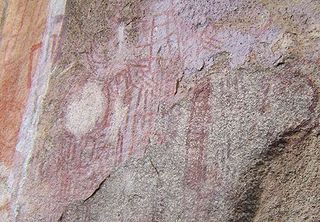
The Chongoni Rock Art Area is a region containing 127 rock art and painting sites depicting the farmer community of the Late Stone Age and Iron Age, located in the forested hills of the Malawi plateau in the Central Region of Malawi.

Chiradzulu Mountain is located in the Shire Highlands of Malawi, approximately 20 km to the north-east of Blantyre, Malawi's main commercial centre. The administrative district of Chiradzulu in southern Malawi was named after this mountain. Chiradzulu Mountain rises to a peak of 1,773m above sea level and is the third highest mountain peak in southern Malawi, after Mulanje Mountain, whose famous Sapitwa peak rises to 3,002m above sea level, and Zomba Mountain, which rises to 2,085m above sea level at its peak.
The South Malawi montane forest–grassland mosaic is an ecoregion of Malawi.
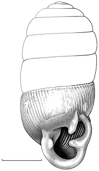
Gulella systemanaturae is a species of minute air-breathing land snail, a terrestrial pulmonate gastropod mollusk in the family Streptaxidae.
Michiru Mountain is located about 5 miles north of the city of Blantyre, Malawi, on the edge of the Great Rift Valley. The summit sits at an elevation of 3,925 feet, although because it rises from a high plateau its prominence is only a few hundred feet. The mountain is known for its many species of birds. The road to Michiru is uneven and can only be accessed by off-road vehicles.

The Matundwe Range is a range of mountains in southernmost Malawi and adjacent Tete Province of Mozambique. The range is located between the Zambezi and Shire rivers just north of their confluence, and the Malawi-Mozambique border runs along the divide between the two rivers' watersheds.

The South Malawi montane forest-grassland mosaic is a montane grasslands and shrublands ecoregion of Tanzania, Malawi, Mozambique, and Zambia.
Ntchisi Mountain is a mountain in central Malawi. It is located in Ntchisi District, east of the town of Ntchisi.
The Misuku Hills are a mountain range in Malawi's Northern Region.

