
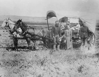
The Oregon Trail was a 2,170-mile (3,490 km) east–west, large-wheeled wagon route and emigrant trail in the United States that connected the Missouri River to valleys in Oregon Territory. The eastern part of the Oregon Trail spanned part of what is now the state of Kansas and nearly all of what are now the states of Nebraska and Wyoming. The western half of the trail spanned most of the current states of Idaho and Oregon.
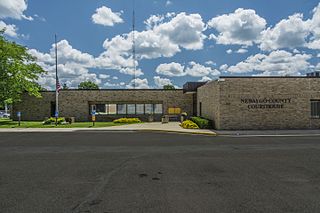
Newaygo County is a county in the U.S. state of Michigan. As of the 2020 United States Census, the population was 49,978. The county seat is White Cloud. The county was created in 1840, and was organized in 1851. It was either named for an Ojibwe leader who signed the Treaty of Saginaw in 1819 or for an Algonquian word meaning "much water".
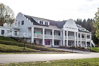
Benzie County is a county in the U.S. state of Michigan. As of the 2020 census, the population was 17,970. The county seat is Beulah. The county was initially set off in 1863 and organized in 1869. At 321 square miles (830 km2), Benzie County is the smallest of the 83 counties in Michigan in terms of land area.

Doniphan County is the most northeastern county in the U.S. state of Kansas. Its county seat is Troy, and its most populous city is Wathena. As of the 2020 census, the county population was 7,510. The county was named after Alexander Doniphan, a Mexican–American War hero. It is bounded on the east by the Missouri river, south by Atchison county, and west by Brown county.

Sheridan is a village in LaSalle County, Illinois, United States. As of the 2020 census, the village's population was 2,431, up from 2,137 at the 2010 census. It is part of the Ottawa Micropolitan Statistical Area.

Sheridan is a town in Adams Township, Hamilton County, Indiana, United States. The population was 2,665 at the 2010 census. The center of population of Indiana is located just northwest of Sheridan.

New Bloomfield is a city in Cedar Township, Callaway County, Missouri, United States. The population was 669 at the 2010 census. It is part of the Jefferson City Metropolitan Statistical Area.

Parnell is a city in northeast Nodaway County, Missouri, United States, near the Platte River. The population was 191 at the 2010 Census. It was home to the father-son horse trainers Ben and Jimmy Jones, whose horses won eight Kentucky Derbies and two Triple Crowns.
Tracy is a city in Platte County, Missouri within the United States, located along the Platte River. The population was 269 at the 2020 census. The city is part of the Kansas City metropolitan area.

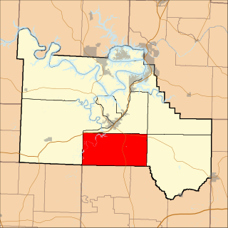
Sheridan is a city in northwest Worth County, Missouri, United States, near the Platte River. The population was 195 at the 2010 census.

The Platte River is a major American river, in the state of Nebraska. It is about 310 mi (500 km) long; measured to its farthest source via its tributary, the North Platte River, it flows for over 1,050 miles (1,690 km). The Platte River is a tributary of the Missouri River, which itself is a tributary of the Mississippi River which flows to the Gulf of Mexico. The Platte over most of its length is a broad, shallow, meandering stream with a sandy bottom and many islands—a braided stream.

The Platte Purchase was a land acquisition in 1836 by the United States government from American Indian tribes of the region. It comprised lands along the east bank of the Missouri River and added 3,149 square miles (8,156 km2) to the northwest corner of the state of Missouri.

The One Hundred and Two River is a tributary of the Platte River of Missouri in northwestern Missouri in the United States. It flows from source tributaries in southwestern Iowa about 80 miles (130 km) to the Platte. Via the Platte, it is part of the watershed of the Missouri River. Much of the river's course has been straightened and channelized.

The Platte River is a tributary of the Missouri River, about 200 miles (320 km) long, in southwestern Iowa and northwestern Missouri in the United States. It is sometimes known as the Little Platte River to distinguish it from the larger Platte River, also a tributary of the Missouri, in nearby Nebraska; the Platte River of Missouri itself has a tributary known as the "Little Platte River".
The history of the U.S. state of Nebraska dates back to its formation as a territory by the Kansas–Nebraska Act, passed by the United States Congress on May 30, 1854. The Nebraska Territory was settled extensively under the Homestead Act of 1862 during the 1860s, and in 1867 was admitted to the Union as the 37th U.S. state. The Plains Indians are the descendants of a long line of succeeding cultures of indigenous peoples in Nebraska who occupied the area for thousands of years before European arrival and continue to do so today.
Warren Township is one of eleven townships in Camden County, Missouri, USA. As of the 2000 census, its population was 2,466.

French people have been present in the U.S. state of Nebraska since before it achieved statehood in 1867. The area was originally claimed by France in 1682 as part of La Louisiane, the extent of which was largely defined by the watershed of the Mississippi River and its tributaries. Over the following centuries, explorers of French ethnicity, many of them French-Canadian, trapped, hunted, and established settlements and trading posts across much of the northern Great Plains, including the territory that would eventually become Nebraska, even in the period after France formally ceded its North American claims to Spain. During the 19th century, fur trading gave way to settlements and farming across the state, and French colonists and French-American migrants continued to operate businesses and build towns in Nebraska. Many of their descendants continue to live in the state.

Colonel Stephen Boyd Miles was a frontiersman, stagecoach magnate, cattle rancher, banker and philanthropist in Nebraska and the greater American Midwest. His obituary in the Falls City Journal stated, "Mr. Miles was a man of great business ability and accumulated much of this world's goods, and left a fortune gained by hard effort, much of it literally dug in the sweat of his brow from the virgin soil of a new country."
Brushy Creek is a stream in Nodaway and Worth counties in Missouri and Taylor County, Iowa, in the United States. It is a tributary of Platte River.
