Related Research Articles

Eagle County Regional Airport is in Gypsum, Colorado, 4 miles from Eagle and 37 miles from Vail. It covers 632 acres (256 ha) and has one runway. The History Channel rated Eagle County Regional Airport as #8 on its list of Most Extreme Airports in July 2010 due to the elevation, weather, approach through mountainous terrain and challenging departure procedures. In 2008–09 the airport completed a runway repaving and extension project, increasing the runway length to 9,000 feet.

Rocky Mountain Metropolitan Airport is a public-use airport located in Broomfield, Colorado, United States. The airport is owned and operated by Jefferson County and is situated midway between Denver and Boulder on U.S. Highway 36. It is located sixteen miles northwest of the central business district of Denver, and is the closest airport to downtown Denver. The airport covers 1,700 acres (688 ha) and has three runways. Formerly known as Jefferson County Airport or Jeffco Airport, the airport was renamed Rocky Mountain Metropolitan Airport on October 10, 2006 although it is sometimes referred to as Rocky Mountain Regional Airport, e.g. 2007-2012 county planning documents.

Yampa Valley Regional Airport is in Routt County, Colorado, two miles southeast of Hayden and about 25 miles (40 km) west of Steamboat Springs. Also known as Yampa Valley Regional Airport, it has the only scheduled passenger flights to northwest Colorado. It is also used by larger business jets that cannot use the smaller Steamboat Springs Airport.

In air traffic control, an area control center (ACC), also known as a center or en-route center, is a facility responsible for controlling aircraft flying in a particular volume of airspace at high altitudes between airport approaches and departures. In the US, such a center is referred to as an air route traffic control center (ARTCC).
ERAM is an FAA Air Traffic Control system designed to "allow faster processing of route requests and in flight route changes".
A Center Weather Service Unit (CWSU) is a National Weather Service (NWS) unit located inside each of the Federal Aviation Administration's 22 Air Route Traffic Control Centers (ARTCC).
ATC Zero is an official term used by the U.S. Federal Aviation Administration (FAA) that means the FAA is unable to safely provide the published ATC services within the airspace managed by a specific facility. The term is always used in conjunction with a facility reference. FAA ATC facilities include Air Route Traffic Control Centers (ARTCC); Terminal Radar Control facility (TRACON), Air Traffic Control Tower (ATCT), Flight Service Stations (FSS), or the Air Traffic Control System Command Center (ATCSCC). The term is defined in FAA Order JO 1900.47, Air Traffic Control Operational Contingency Plans. It is one of three designations used by the FAA to describe degraded operations and invoke operational contingency plans.
The National Airspace System (NAS) is the airspace, navigation facilities and airports of the United States along with their associated information, services, rules, regulations, policies, procedures, personnel and equipment. It includes components shared jointly with the military. It is one of the most complex aviation systems in the world, and services air travel in the United States and over large portions of the world's oceans.
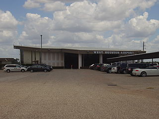
West Houston Airport is a privately owned, public use airport in Harris County, Texas, 15 miles west of Downtown Houston in the Greater Katy area. It opened in 1962 and was Lakeside Airport until the early 1980s due to its location near the edge of Addicks reservoir.
Chicago Air Route Traffic Control Center (ZAU) is one of 22 Air Route Traffic Control Centers (ARTCCs) operated by the United States Federal Aviation Administration. It is located at 619 W. New Indian Trail Rd., Aurora, Illinois.

The Air Traffic Organization (ATO) is America's air navigation service provider, as the operations arm of the Federal Aviation Administration. Its customers are commercial and private aviation and the military, and it employs more than 35,000 controllers, technicians, engineers and support workers.
Indianapolis Air Route Traffic Control Center (ZID), is one of 22 established FAA Area Control Centers, and is physically located at 1850 South Sigsbee Street, Indianapolis, Indiana,.
Jacksonville Air Route Traffic Control Center (ZJX), is one of 22 Area Control Centers in the United States. It is located at 37075 Aviation Ln, Hilliard, Florida.
Kansas City Air Route Traffic Control Center, is one of 22 Federal Aviation Administration (FAA) Area Control Centers. It is located at 250 S. Rogers Rd. Olathe, Kansas, United States.
Salt Lake City Air Route Traffic Control Center (ZLC) is one of 22 FAA Area Control Centers in the United States. It is located in Salt Lake City, Utah, adjacent to Salt Lake City International Airport. It was opened in 1939 and was originally located on the third floor of the old Salt Lake City International Airport terminal. The Salt Lake Center (ZLC) covers one of the largest geographical areas of any other control center, totaling approximately 350,000 squares miles.
Miami Air Route Traffic Control Center is one of 22 United States air route traffic control centers (ARTCs), or area control centers, located at 7500 N.W. 58th st, Miami, Florida.
"Memphis Air Route Traffic Control Center (ZME) is one of 22 United States Federal Aviation Administration (FAA) Area Control Centers and is located at 3229 Democrat Rd. Memphis, Tennessee 38118, United States
Minneapolis Air Route Traffic Control Center (ZMP), is one of 22 Area Control Centers. It is located at 512 Division Street in Farmington, Minnesota, United States.
Oakland Air Route Traffic Control Center (ZOA), is one of 22 Area Control Centers in the United States. It is located at 5125 Central Ave, Fremont, California.
"Atlanta Air Route Traffic Control Center (ZTL) is one of 22 Air Route Traffic Control Centers operated by the United States Federal Aviation Administration. It is located at 299 Woolsey Rd, Hampton, Georgia, United States.
References
- ↑ Federal Aviation Administration (FAA). (2010, April 28). Air route traffic control centers. Retrieved from https://www.faa.gov/about/office_org/headquarters_offices/ato/service_units/air_traffic_services/artcc/
- ↑ StuckMic.com. (2012). Colorado Air Traffic Control Facilities. Retrieved from http://www.stuckmic.com/colorado-air-traffic-control-facilities.html
- ↑ Federal Aviation Administration. (2018). Air Traffic Activity System (ATADS. Retrieved from http://aspm.faa.gov/opsnet/sys/Center.asp
- ↑ Federal Aviation Administration. "Facility Orientation Guide: Denver ARTCC;". Federal Aviation Administration. Retrieved 14 April 2013.
- ↑ Federal Aviation Administration. "Facility Orientation Guide: Denver ARTCC;". Federal Aviation Administration. Retrieved 14 April 2013.