
Dera Ismail Khan, abbreviated as D.I. Khan, is a city and capital of Dera Ismail Khan District, located in Khyber Pakhtunkhwa, Pakistan. It is the 37th largest city of Pakistan and fifth largest in the province of Khyber Pakhtunkhwa by population. Dera Ismail Khan is situated on the west bank of the Indus River, at its junction with the Gomal River.
Dera Ismail Khan District, often abbreviated as D.I. Khan is a district in the Dera Ismail Khan division of the Khyber Pakhtunkhwa province of Pakistan. The capital of the district is the town of Dera Ismail Khan. The district has an area of 9,334 km2 (3,604 sq mi) and a population of 1,627,132 as of the 2017 Census.

Zhob, formerly known as Appozai, is a city and district headquarters of the Zhob District in the Balochistan province of Pakistan. Zhob is located on the banks of the Zhob river. It lies 337 kilometres away from Quetta, the capital of Balochistan.
Dera Ismail Khan Airport or D. I. Khan Airport is situated 10 km away from the city centre of Dera Ismail Khan, a city in Khyber-Pakhtunkhwa province of Pakistan. This is the only airport besides Bannu Airport that connects the southern districts of Khyber-Pakhtunkhwa with other parts of the country. The airport operations have remained suspended for a long time for various reasons.

Bannu Division is one of seven divisions in Pakistan's Khyber Pakhtunkhwa province. It consists of three districts: Bannu, Lakki Marwat, and North Waziristan. According to the 2017 Pakistani Census, the division had a population of 2,656,801, making it the least populous division in the province, but it spans 9,975 km2 (3,851 sq mi) of area, and this makes it the third-smallest division by area in the province. Lakki Marwat is the largest city of Bannu Division, with around 60,000 people, while the division's namesake and second-largest city is Bannu, with just under 50,000 people. The division borders Dera Ismail Khan Division to the south and west, Kohat Division to the north and east, and the province of Punjab, Pakistan to its east. CNIC code of Bannu Division is 11.

Dera Ismail Khan Division is an administrative division of Khyber Pakhtunkhwa Province, Pakistan. It is the southernmost division of Khyber Pakhtunkhwa. CNIC code of Dera Ismail Khan Division is 12.
Dera Ismail Khan Tehsil is a tehsil located in Dera Ismail Khan District, Khyber Pakhtunkhwa, Pakistan.

Kulachi Tehsil is a tehsil located in Dera Ismail Khan District, Khyber Pakhtunkhwa, Pakistan.
Paharpur Tehsil is a tehsil located in Dera Ismail Khan District, Khyber Pakhtunkhwa, Pakistan.

South Punjab, also proposed as Bahawalpur-South Punjab or Sairaikistan, are the names for the proposals to create a new so called province in Pakistan, out of the southern regions of Punjab. The region comprises the Bahawalpur, Multan, Sahiwal and Dera Ghazi Khan divisions. The proposed province would form about 52 percent of the total area and almost 40 percent of the population of the current Punjab province.

Sardar Ali Amin Khan Gandapur is a Pakistani politician who is currently serving as the 18th Chief Minister of Khyber Pakhtunkhwa, in office since 2 March 2024. He served as the Federal Minister for Kashmir Affairs and Gilgit-Baltistan from 5 October 2018 to 10 April 2022. He had been a member of the National Assembly of Pakistan from August 2018 till January 2023.
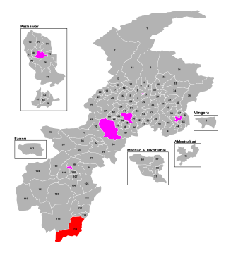
PK-114 Dera Ismail Khan-IV is a constituency for the Khyber Pakhtunkhwa Assembly of the Khyber Pakhtunkhwa province of Pakistan.

The M-14 Motorway, also known as the Islamabad–Dera Ismail Khan Motorway and the Hakla–Yarik Motorway, is a four-lane north–south motorway in Pakistan. The 285-kilometre-long (177 mi) motorway is a part of the Western Alignment of the China–Pakistan Economic Corridor, and offers high speed road connections between the Islamabad-Rawalpindi metropolitan area, and the southern parts of Khyber Pakhtunkhwa province around Dera Ismail Khan.
Dera Ismail Khan is a city in Khyber Pakhtunkhwa, Pakistan
Paroa is a tehsil located in Dera Ismail Khan District, Khyber Pakhtunkhwa, Pakistan. The population is 292,466 according to the 2017 census.
Wana Tehsil is a subdivision located in Lower South Waziristan District District, Khyber Pakhtunkhwa, Pakistan. The population is 152,881 according to the 2017 census.
Tank is a tehsil located in Tank District, Khyber Pakhtunkhwa, Pakistan.

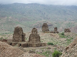
Hinduism is a minority religion in the Khyber Pakhtunkhwa province followed by 0.02% of the population of the province as per 2017 Census.

