
The Faubourg Marigny is a neighborhood of the city of New Orleans, Louisiana, United States.

Bywater is a neighborhood of the city of New Orleans. A subdistrict of the Bywater District Area, its boundaries as defined by the City Planning Commission are: Florida Avenue to the north, the Industrial Canal to the east, the Mississippi River to the south, and the railroad tracks along Homer Plessy Way to the west. Bywater is part of the Ninth Ward of New Orleans. It includes part or all of Bywater Historic District, which is listed on the National Register of Historic Places.

The Ninth Ward or 9th Ward is a distinctive region of New Orleans, Louisiana, which is located in the easternmost downriver portion of the city. It is geographically the largest of the 17 Wards of New Orleans. On the south, the Ninth Ward is bounded by the Mississippi River. On the western or "upriver" side, the Ninth Ward is bounded by Franklin Avenue, then Almonaster Avenue, then People's Avenue. From the north end of People's Avenue the boundary continues on a straight line north to Lake Pontchartrain; this line is the boundary between the Ninth and the city's Eighth Ward. The Lake forms the north and northeastern end of the ward. St. Bernard Parish is the boundary to the southeast, Lake Borgne farther southeast and east, and the end of Orleans Parish to the east at the Rigolets.

Navarre is a neighborhood of the city of New Orleans. A subdistrict of the Lakeview District Area, its boundaries as defined by the City Planning Commission are: I-610, Canal Boulevard and Florida Boulevard to the north, Orleans Avenue to the east, City Park Avenue to the south and the Pontchartrain Expressway and Pontchartrain Boulevard to the west.

Gentilly is a broad, predominantly middle-class and racially diverse section of New Orleans, Louisiana. The Gentilly neighborhood is bounded by Lake Pontchartrain to the north, France Road to the east, Bayou St. John to the west, and CSX Transportation railroad tracks to the south.

Lakeview is a neighborhood of the city of New Orleans. A subdistrict of the Lakeview District Area, its boundaries as defined by the City Planning Commission are: Robert E Lee Boulevard to the north, Orleans Avenue to the east, Florida Boulevard, Canal Boulevard and I-610 to the south and Pontchartrain Boulevard to the west. Lakeview is sometimes used to describe the entire area bounded by Lake Pontchartrain to the north, the Orleans Avenue Canal to the east, City Park Avenue to the south and the 17th Street Canal to the west. This larger definition includes the West End, Lakewood and Navarre neighborhoods, as well as the Lakefront neighborhoods of Lakeshore and Lake Vista.
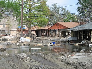
Desire Projects was a housing project located in the Ninth Ward of New Orleans, Louisiana. These projects were the largest in the nation and consisted of about 262 two-story brick buildings, containing about 1,860 units across 98.5 acres of land. The overall conditions of the projects were deplorable from the moment they were put into place in the later part of the 1950s. The projects were meant to serve the large number of underprivileged African-American residents in the New Orleans area. Soon it became a place of despair, and Desire eventually evolved into a dark no-man's land, leaving many residents infested with problems and little or no help from the government. Located in a cypress swamp and dumping ground, Desire was known as the poorest housing development in New Orleans—it was bordered by railroad tracks, the Mississippi River, the Industrial Canal and a corridor of industrial plants.

Milneburg is a neighborhood of the city of New Orleans. A subdistrict of the Gentilly District Area, its boundaries as defined by the City Planning Commission are: Leon C. Simon Drive to the north, People's Avenue to the east, Filmore Ave to the south and Elysian Fields Avenue to the west, putting it within the 8th Ward of New Orleans. The Milneburg neighborhood takes its name from Milneburg, a historic town and neighborhood formerly located a short distance north of the modern neighborhood.

Gentilly Woods is a neighborhood of the city of New Orleans. A subdistrict of the Gentilly District Area, its boundaries as defined by the City Planning Commission are: Dreux Avenue to the north, Industrial Canal to the east, Gentilly Boulevard to the south and People's Avenue to the west.

Fontainebleau and Marlyville are jointly designated as a neighborhood of the city of New Orleans. A subdistrict of the Uptown/Carrollton Area, its boundaries as defined by the New Orleans City Planning Commission are: Colapissa and Broadway Streets and MLK Boulevard to the north, Norman C. Francis Parkway, Octavia Street, Fontainebleau Drive, Nashville Avenue, South Rocheblave, Robert and South Tonti Street and Jefferson Avenue to the east, South Claiborne Avenue, Lowerline and Spruce Streets to the south and South Carrollton Avenue to the west.
Fairgrounds is a neighborhood of the city of New Orleans. A subdistrict of the Mid-City District Area, its boundaries as defined by the New Orleans City Planning Commission are: Florida Avenue, Dugue, Treasure, Republic and Abundance Streets to the north, North Broad Street to the east, Esplanade Avenue to the south and Bayou St. John to the west.
Dillard is a neighborhood of the city of New Orleans. A subdistrict of the Gentilly District Area, its boundaries as defined by the City Planning Commission are: Mirabeau Avenue to the north, Elysian Fields Avenue to the east, Benefit Street and I-610 to the south and Paris Avenue, Pratt Drive and the London Avenue Canal to the west.

Filmore is a neighborhood of the city of New Orleans. A subdistrict of the Gentilly District Area, its boundaries as defined by the City Planning Commission are: * Allen Toussaint Boulevard to the north, London Avenue Canal to the east, Press Drive, Paris Avenue and Harrison Avenue to the south and Bayou St. John to the west.

Gentilly Terrace is a neighborhood of the city of New Orleans. A subdistrict of the Gentilly District Area, its boundaries as defined by the City Planning Commission are: Filmore Avenue to the north, People's Avenue to the east, Gentilly Boulevard to the south and Elysian Fields Avenue to the west. Gentilly Terrace may be further divided into Gentilly Terrace & Gardens, Edgewood Park and Fairmont Park, all three of which possess organized, distinct, and active neighborhood associations.
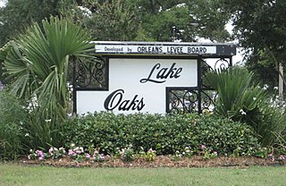
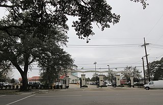
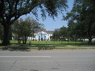
Lake Terrace/Lake Oaks is a neighborhood of the city of New Orleans, Louisiana. A sub-district of the city's Gentilly District, its boundaries as defined by the City Planning Commission are: Lake Pontchartrain to the north; the Industrial Canal to the east; Leon C. Simon Drive, Elysian Fields Avenue, New York Street, the London Avenue Canal, and Allen Toussaint Boulevard to the south; and Bayou St. John to the west. The neighborhood comprises the Lake Terrace and Lake Oaks subdivisions, the principal campus of the University of New Orleans, and the University of New Orleans Research & Technology Park — all built on land reclaimed from Lake Pontchartrain.
St. Anthony is a neighborhood of the city of New Orleans. A subdistrict of the Gentilly District Area, its boundaries as defined by the City Planning Commission are: New York Street to the north, Elysian Fields Avenue to the east, Mirabeau Avenue to the south and the London Avenue Canal to the west.
Florida Area is a neighborhood of the city of New Orleans. A subdistrict of the Bywater District Area, its boundaries as defined by the City Planning Commission are: Florida Boulevard, Gallier, Law, Congress and North Dorgenois Streets to the north; Mazant Street to the east; North Galvez Street to the south; and Montegut Street, Law Street, and Almonaster Avenue to the west.
St. Claude is a neighborhood of the city of New Orleans. A subdistrict of the Bywater District Area, its boundaries as defined by the City Planning Commission are: Law, Montegut and North Galvez Streets to the north, Lesseps Street to the east, Burgundy Street, Clouet Street and St. Claude Avenue to the south and Franklin Avenue to the west.

St. Roch is a neighborhood of the U.S. city of New Orleans. A subdistrict of the Bywater District Area, its boundaries as defined by the City Planning Commission are: Lafreniere Street, Paris Avenue, I-610, Benefit Street, and Dahlia Walk to the north; People's and Almonaster Avenues to the east; St. Claude Avenue to the south; Elysian Fields Avenue, Hope, Frenchmen, Duels, St. Anthony, Industry, Allen, & Agriculture Streets, A.P. Tureaud Avenue, Abundance, Republic, Treasure, & Dugue Streets, and Florida & St. Bernard Avenues to the west.

Holy Cross is a neighborhood of the city of New Orleans. A subdistrict of the Lower Ninth Ward District Area, its boundaries as defined by the City Planning Commission are: St. Claude Avenue to the north, St. Bernard Parish to the east, the Mississippi River to the south and the Industrial Canal to the west.
