
The geography of Antarctica is dominated by its south polar location and, thus, by ice. The Antarctic continent, located in the Earth's southern hemisphere, is centered asymmetrically around the South Pole and largely south of the Antarctic Circle. It is washed by the Southern Ocean or, depending on definition, the southern Pacific, Atlantic, and Indian Oceans. It has an area of more than 14 million km2. Antarctica is the largest ice desert in the world.

The Antarctic is a polar region around Earth's South Pole, opposite the Arctic region around the North Pole.

The French Southern and Antarctic Lands is an overseas territory of France. It consists of:
- Adélie Land, the French claim on the continent of Antarctica.
- Crozet Islands, a group in the southern Indian Ocean, south of Madagascar.
- Kerguelen Islands, a group of volcanic islands in the southern Indian Ocean, southeast of Africa.
- Saint Paul and Amsterdam Islands, a group to the north of the Kerguelen Islands.
- Scattered Islands, a dispersed group of islands around the coast of Madagascar.

The Territory of Heard Island and McDonald Islands (HIMI) is an Australian external territory comprising a volcanic group of mostly barren Antarctic islands, about two-thirds of the way from Madagascar to Antarctica. The group's overall area is 372 km2 (144 sq mi) and it has 101.9 km (63 mi) of coastline. Discovered in the mid-19th century, the islands lie on the Kerguelen Plateau in the Indian Ocean and have been an Australian territory since 1947. They contain Australia's only two active volcanoes. The summit of one, Mawson Peak, is higher than any mountain in all other Australian states or territories, except Dome Argus, Mount McClintock and Mount Menzies in the Australian Antarctic Territory.
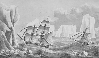
The history of Antarctica emerges from early Western theories of a vast continent, known as Terra Australis, believed to exist in the far south of the globe. The term Antarctic, referring to the opposite of the Arctic Circle, was coined by Marinus of Tyre in the 2nd century AD.

The Ross Dependency is a region of Antarctica defined by a sector originating at the South Pole, passing along longitudes 160° east to 150° west, and terminating at latitude 60° south. It is claimed by New Zealand, a claim accepted only by the other six countries with territorial claims in Antarctica. Under the 1961 Antarctic Treaty, of which all territorial claimants are signatories, including New Zealand, all claims are held in abeyance. Article IV states: "No acts or activities taking place while the present Treaty is in force shall constitute a basis for asserting, supporting or denying a claim to territorial sovereignty in Antarctica or create any rights of sovereignty in Antarctica".

The Ross Sea is a deep bay of the Southern Ocean in Antarctica, between Victoria Land and Marie Byrd Land and within the Ross Embayment, and is the southernmost sea on Earth. It derives its name from the British explorer James Clark Ross who visited this area in 1841. To the west of the sea lies Ross Island and Victoria Land, to the east Roosevelt Island and Edward VII Peninsula in Marie Byrd Land, while the southernmost part is covered by the Ross Ice Shelf, and is about 200 miles (320 km) from the South Pole. Its boundaries and area have been defined by the New Zealand National Institute of Water and Atmospheric Research as having an area of 637,000 square kilometres (246,000 sq mi).

The Antarctic Peninsula, known as O'Higgins Land in Chile and Tierra de San Martín in Argentina, and originally as Graham Land in the United Kingdom and the Palmer Peninsula in the United States, is the northernmost part of mainland Antarctica.

Iceberg B-15 was the largest recorded iceberg by area. It measured around 295 by 37 kilometres, with a surface area of 11,000 square kilometres, about the size of the island of Jamaica. Calved from the Ross Ice Shelf of Antarctica in March 2000, Iceberg B-15 broke up into smaller icebergs, the largest of which was named Iceberg B-15-A. In 2003, B-15A drifted away from Ross Island into the Ross Sea and headed north, eventually breaking up into several smaller icebergs in October 2005. In 2018, a large piece of the original iceberg was steadily moving northward, located between the Falkland Islands and South Georgia Island. As of August 2023, the U.S. National Ice Center (USNIC) still lists one extant piece of B-15 that meets the minimum threshold for tracking. This iceberg, B-15AB, measures 20 km × 7 km ; it is currently grounded off the coast of Antarctica in the western sector of the Amery region.

West Antarctica, or Lesser Antarctica, one of the two major regions of Antarctica, is the part of that continent that lies within the Western Hemisphere, and includes the Antarctic Peninsula. It is separated from East Antarctica by the Transantarctic Mountains and is covered by the West Antarctic Ice Sheet. It lies between the Ross Sea, and the Weddell Sea. It may be considered a giant peninsula, stretching from the South Pole towards the tip of South America.

Cape Hallett is a snow-free area on the northern tip of the Hallett Peninsula on the Ross Sea coast of Victoria Land, East Antarctica. Cape Adare lies 100 km (62 mi) to the north.
East Antarctica, also called Greater Antarctica, constitutes the majority (two-thirds) of the Antarctic continent, lying primarily in the Eastern Hemisphere south of the Indian Ocean, and separated from West Antarctica by the Transantarctic Mountains. It is generally greater in elevation than West Antarctica, and includes the Gamburtsev Mountain Range in the center. The geographic South Pole is located within East Antarctica.

Cape Adare is a prominent cape of black basalt forming the northern tip of the Adare Peninsula and the north-easternmost extremity of Victoria Land, East Antarctica.

Seymour Island or Marambio Island, is an island in the chain of 16 major islands around the tip of the Graham Land on the Antarctic Peninsula. Graham Land is the closest part of Antarctica to South America. It lies within the section of the island chain that resides off the west side of the peninsula's northernmost tip. Within that section, it is separated from Snow Hill Island by Picnic Passage, and sits just east of the larger key, James Ross Island, and its smaller, neighboring island, Vega Island.

Antarctica is Earth's southernmost and least-populated continent. Situated almost entirely south of the Antarctic Circle and surrounded by the Southern Ocean, it contains the geographic South Pole. Antarctica is the fifth-largest continent, being about 40% larger than Europe, and has an area of 14,200,000 km2 (5,500,000 sq mi). Most of Antarctica is covered by the Antarctic ice sheet, with an average thickness of 1.9 km (1.2 mi).
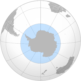
The Southern Ocean, also known as the Antarctic Ocean, comprises the southernmost waters of the world ocean, generally taken to be south of 60° S latitude and encircling Antarctica. With a size of 20,327,000 km2 (7,848,000 sq mi), it is regarded as the second-smallest of the five principal oceanic divisions: smaller than the Pacific, Atlantic, and Indian oceans but larger than the Arctic Ocean. Since the 1980s, the Southern Ocean has been subject to rapid climate change, which has led to changes in the marine ecosystem.
Major explorations of Earth continued after the Age of Discovery. By the early seventeenth century, vessels were sufficiently well built and their navigators competent enough to travel to virtually anywhere on the planet by sea. In the 17th century, Dutch explorers such as Willem Jansz and Abel Tasman explored the coasts of Australia. Spanish expeditions from Peru explored the South Pacific and discovered archipelagos such as Vanuatu and the Pitcairn Islands. Luis Vaez de Torres chartered the coasts of New Guinea and the Solomon Islands, and discovered the strait that bears his name. European naval exploration mapped the western and northern coasts of Australia, but the east coast had to wait for over a century. Eighteenth-century British explorer James Cook mapped much of Polynesia and traveled as far north as Alaska and as far south as the Antarctic Circle. In the later 18th century, the Pacific became a focus of renewed interest, with Spanish expeditions, followed by Northern European ones, reaching the coasts of northern British Columbia and Alaska.

The wildlife of Antarctica are extremophiles, having adapted to the dryness, low temperatures, and high exposure common in Antarctica. The extreme weather of the interior contrasts to the relatively mild conditions on the Antarctic Peninsula and the subantarctic islands, which have warmer temperatures and more liquid water. Much of the ocean around the mainland is covered by sea ice. The oceans themselves are a more stable environment for life, both in the water column and on the seabed.
The McMurdo Volcanic Group is a large group of Cenozoic volcanic rocks in the western Ross Sea and central Transantarctic Mountains areas of Antarctica. It is one of the largest provinces of alkaline volcanism in the world, having formed as a result of continental rifting along the West Antarctic Rift System. The McMurdo Volcanic Group is part of the Western Ross Supergroup, a stratigraphic unit that also includes the Meander Intrusive Group.
Antarcticinella is a genus of springtails native to Antarctica. It is monotypic, being represented by the single species Antarcticinella monoculata. The genus and species were original described by John Salmon in 1965.