
Imljani is a village in Republika Srpska, which is located in the municipality of Kneževo. Since 1954, Imljani was one of local communities of Former Šiprage Municipality in Former Kotor Varoš County.
Šiprage is a settlement municipality in the Bosnia and Herzegovina, Republika Srpska entity, Kotor Varoš Municipality.

Ilomska is right tributary of the Ugar river in (Bosnia). It is about 20 kilometres (12 mi) in length, and its source is Vlašić Mountain. It is an essential body of water for surrounding wildlife. Ilomska flows between the Žežnička Greda and Javorak mountains. It has a curved flow around Lisina and Runjavica mountains, through coniferous and mixed spruce-beech woods.

The Vrbanja is a river in Central Bosnia, Bosnia and Herzegovina; with Ugar, the largest right tributary of the Vrbas. Its basin covers an area of approximately 703.5 km2. The Vrbanja has significant hydropower potential. There are many different estimations of the Vrbanja's length, from 70.5 km and 84 km to 95.4 km.
The Ćorkovac is an eastern confluent of the Vrbanja river in Bosnia. It begins on the north-eastern slopes of the Vlašić mountain's plateau, and the mouth opens at Šiprage, where the town's sawmill was. The spring of Ćorkovac is 1,150 metres above sea level, and is around 6 kilometres long. It flows between the Jasen and Stražbenica mountains to its estuary. The watermills were in operation until the 1960s.
The Grabovička River is one of the left tributaries of the Vrbanja River. It rises near Miljevići village, below the road to Golo Brdo, on the south slopes of Ježica and Zastijenje.

The Bobovica is the richest tributary of upper flow of Vrbanja river, although it is marked on some maps as "Kruševica". However, the latter name is for another river about 30 kilometers downstream. Bobovica's length is around 12 km. Its mouth is in Kruševo Brdo. During the 1960s, there were about 15 mills on this river, the mouth of which is in Obodnik.

The Ugar is a river of Bosnia, a tributary of the Vrbas river. It originates at the slopes of Vlašić, upstream of Sažići and Melina villages, a watershed area of Vrbanja, Ilomska and Bila rivers. The valley along the Ugar is known as Pougarje.
The Čudnić is a left, western tributary of the Vrbanja in Bosnia and Herzegovina. It flows to Panići village and empties into the village of Čudić in the village of Kruševo Brdo, below Arapov Brijeg. It springs on the southeastern slopes of the lower Vlašić's plateau, below the Ilomska and its tributaries. The spring is on a riverhead with the Kovačevića creek and the Ćorkovac creek. The tributary flows deep and fast; it is the local population's belief that the Čudnić is flowing over a part of the water of the Ilomska confluence.
Kruševo Brdo is a village in Bosnia and Herzegovina, Republika Srpska, municipality Kotor Varoš in geographical region Bosanska Krajina. It is administratively divided into Krševo Brdo I and II.
Vigošća is a left tributary of the Vrbanja river in Bosnia and Herzegovina. It rises on the northern slopes of Ježica mountain by strong spring Vrelo, on the north slopes of Ježica mountain.
Korićani is a village in central Bosnia and Herzegovina. Before the War in Bosnia, Korićani was the (administrative) united village. The Dayton Agreement is divided this settlement into two entities. Upper Korićani is today in the Federation of Bosnia and Herzegovina, and Lower Korićani in the Republic of Srpska.
Kruševica is the strongest right tributary of Vrbanja in central Bosnia. It rises from two streams whose source is on the northeast slopes of the Očauš Mountain. The source is exposed to the Borja Mountain. On geographic maps, Kruševica is often marked as another river (Bobovica), whose estuary is around 20 miles upstream.
Petrovo field is a small field on Podvlašić plateau, as part of Vlašić mountain group, and it's positioned at an altitude of about 1140 meters to 1220 meters a.s.l.
Petrovo Polje is a village in Central Bosnia, Bosnia and Herzegovina, the Republika Srpska, Kneževo Municipality. Until the 1960s it belonged to the former municipality Šiprage, and then for some time and the municipality of Kotor Varoš. From ancient times to the fall of the Kingdom of Yugoslavia, the village belonged to the Church municipality Imljani.
Meokrnje is a mountain in Central Bosnia (Bosnia and Herzegovina, in the masiff chain of internal Dinaris mountains. This is the greatest elevation between Vlašić and Manjača - the northeast.
Mala Ilomska is very short right tributary of Ilomska – one of right tributaries of Ugar − in Central Bosnia, Bosnia and Herzegovina, Skender Vakuf Municipality. This small river is formed from seven springs and streams at the Petrovo field, on the southwestern slopes of the hill Omarike. The min source is at an altitude of about 1230 m, and one of the registered is Bijeljino spring, near the hamlet of Nikodinovići. In addition to these, there are no significant tributaries.
Crna River is the larger left tributary of Ilomska River. It originates from Duboki jarak at an altitude of 1380 m, below Blatnica Hill. The upper waterflow goes south-east, between Omanjača and the Ravan on Runjavica, above the eponymous village (Blatnica). After leaving the ravine, the river flows around Jove masiff turn right to the north to the mouth.During Austro-Hungarian rule, a narrow-gauge railway was built through the forest along the river for the exploitation of forest resources. The timber industry continues to harvest spruce and fir trees there.
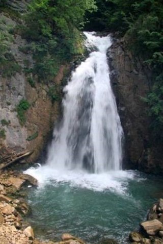
Ilomska Waterfalls are a set of waterfalls on the Ilomska river, right confluent of Ugar river in Central Bosnia. Both of these rivers rise from Vlašić Mountain massif.
Ćorkovići (Ћорковићи) is populated place in Bosnia and Herzegovina, Kotor Varoš Municipality in Republika Srpska. In 1991, in this village lived 175 inhabitants, and 2013. : 101.


