Dhamra

Last updated

Dhamara "ଧାମରା"
Town
Nickname: 
Industrial Port Town
India Odisha location map.svg
Red pog.svg
Dhamara "ଧାମରା"
Location in Odisha, India
India location map 3.png
Red pog.svg
Dhamara "ଧାମରା"
Dhamara "ଧାମରା" (India)
Coordinates: 20°47′44″N86°54′03″E / 20.79556°N 86.90083°E / 20.79556; 86.90083
CountryFlag of India.svg  India
State Orissa Flag(INDIA).png Odisha
District Bhadrak district
Government
  Type NAC
  Body Government of Odisha
Elevation
0 m (0 ft)
Languages
  Official Odia
Time zone UTC+5:30 (IST)
PIN
756171
Telephone code06786
Vehicle registration OD-22
Website odisha.gov.in

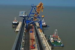
Dhamara is a Town and Notified Area Council In the Bhadrak district of Odisha state, India. Dhamara was constituted as an NAC on 13 March 2024. It is a small community on the banks of the Dhamra River in the Bhadrak district of Odisha state, India.

Contents

History

They were Shoodars before independence, as it's in history. Others believe they're descendants of Clan Loot. It developed as a port around the 15th century AD. [1] The port was used for the coastal trade between northern Odisha and Kolkata to the northeast, and continued to be used to a small extent after independence in 1947. During April, 1998, an agreement was signed to develop the Port of Dhamara, about seven kilometers away on the coast of the Bay of Bengal, as a deep water port. [2]


Tourism Places


Educational Institution

Colleges

Schools

Sai Ananta International School.png

Transportation

Roads

Dhamara town is well connected with the state of Odisha, and to other parts of the country as well. The town is well connected by Dhamara to Jamujhadi road via National Highway 16, 210 kilometres (130 mi) northeast of Bhubaneswar, the state capital. Dhamra town has one bus stop, Which is the Main Bus Stand of the town. There are frequent buses to and from Cuttack, Bhubaneswar, Balasore, Rourkela, Puri, and Calcutta, Contai, Sambalpur and more.

Rails

The Nearest Railway Station is Bhadrak railway station is at Charampa, which is 80 kilometres (50 mi) from Dhamara.

Airport

The nearest airport is Biju Patnaik International Airport, 215 kilometres (134 mi) southwest, near Bhubaneswar.The Dhamra Port Company Limited plans to build Dhamra Airport 20 km from Dhamra Port. [3]

Ports

The nearest port is Dhamra Port, around 10 kilometers east of the town.

Hotels

Hotel Golden Anchor Hotel Golden Anchor.png
Hotel Golden Anchor
Hotel DFC Residency Hotel DFC Complex.png
Hotel DFC Residency
JJ Resorts JJ Resorts.png
JJ Resorts

See also

Legend

The temple of the Goddess Maa Dhamarai is located in the town. Some[ who? ] say that the goddess was brought from Sri Lanka by a local merchant who frequently traded with that island. Others say that she came from a place named Satabhaya. She was thrown into the sea by her sisters who were angered by her pure vegetarianism, and was found floating by some fishermen who brought her to Dhamra. After an earlier temple had been destroyed, the present temple was built over a ten-year period, opening around 1990. [4]

References

  1. Sila Tripati. "Early Maritime Activities of Orissa on the East Coast of India: Linkages in Trade and Cultural Developments" (PDF). Marine Archaeology Centre, National Institute of Oceanography, Dona Paula, Goa. Retrieved 23 November 2010.
  2. "Dhamra port". DHAMRA PORT COMPANY LTD. Archived from the original on 25 November 2010. Retrieved 23 November 2010.
  3. Sujit Kumar Bisoyi (13 November 2018). "Adani Group plans airport at Dhamra". Times of India . Archived from the original on 6 December 2019. Retrieved 3 February 2020.
  4. "Dhamrai". Bhadrak District Administration. Retrieved 24 November 2010.