Historical Importance
The importance of this village lies in it having evidence of an historical palace or fort.
The village is attempting to get India's Archaeological Department to have a look. The villagers found one buried sword near the temple while doing renovation work. The sword was sent to a museum, but still there is no progress in the way of revealing the history of village. While the Public Health department was working for digging water tank, a number of items were found - a small clay artefact, iron to make the small artifact and ash about 16 feet (5m) underground.
Today anyone can have a look at the lime-made remains of the boundary wall and other some remains of the underground palace. The village has the Krishi Vigyan Kendra for Hamirpur district located here helping the local economy to improve by adoption of modern methodologies in farm sector

Solan is a town in the Indian state of Himachal Pradesh and the district headquarters of Solan district. The 3rd largest Municipal Corporation of Himachal Pradesh after Shimla and Dharamshala, it is located 45.5 kilometres (28 mi) south of the state capital, Shimla, at an average elevation of 1,550 metres (5,090 ft). The place is named after the Hindu goddess Shoolini Devi. Every year in June, a fair venerating the goddess is held, featuring a 3-day mela at the central Thodo ground. Solan was the capital of the erstwhile princely state, Baghat.

Kangra is the most populous district of the Indian state of Himachal Pradesh. Dharamshala is the administrative headquarters of the district.

Hamirpur district is in the Indian state of Himachal Pradesh. The headquarters of the district are in the town of Hamirpur. With an area of 1,118 square kilometres or 432 square miles, it is the smallest district of Himachal Pradesh.

Mandi district is one of the central districts of Himachal Pradesh state in northern India. The town of Mandi is the headquarters of the district. The town has mythological and historical significance and boasts of a unique temple architecture. It is referred to as Chhoti Kashi as there are many ancient temples in the city and on the banks of river Beas.

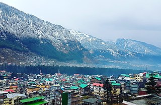
Manali is a town in the Indian state of Himachal Pradesh. It is situated in the northern end of the Kullu Valley, formed by the Beas River. The town is located in the Kullu district, approximately 270 kilometres (170 mi) north of the state capital of Shimla and 544 kilometres (338 mi) northeast of the national capital of Delhi. With a population of 8,096 people recorded in the 2011 Indian census Manali is the beginning of an ancient trade route through Lahaul and Ladakh, over the Karakoram Pass and onto Yarkand and Hotan in the Tarim Basin of China. Manali is a popular tourist destination in India and serves as the gateway to the Lahaul and Spiti district as well as the city of Leh in Ladakh.

Bilaspur is a town and a municipal council in Bilaspur district in the Indian state of Himachal Pradesh.

Hamirpur is a Municipal Council and the headquarters of Hamirpur district in the Indian state of Himachal Pradesh. It is covered by Shivalik Ranges. Hamirpur is located in the Lower West Central Outer Himalayas at an average elevation of 790 M above sea level. Far northern High Altitude Dhauladhar Ranges overlook the city. It is also a major junction on National Highway 3 While National Highway 103 starts at Here. Hamirpur is Famous for its High literacy rate, Educational Institutions and Traditional Festival Of Hamir Utsav. Hamirpur City is spread from Jhaniari to Bhota along NH 3 and NH 103 and is a prominent commercial centre for the district. It is Connected to the National Capital with regular HRTC Volvo and ordinary Buses. The nearest Airport is Kangra Airport and Mohali International Airport While the nearest Railway is in Una at 79 km. Hamirpur City is surrounded by Pine tree forests and has a good city infrastructure ranging from Quality Educational Institutions, NIT, State Universities and Skill Learning centres.

Situated on the left bank of river Beas at an altitude of 1,800 meters, Naggar is an ancient town in Kullu district of Himachal Pradesh, India. It was once capital of the Kullu kingdom.

Kulpahar is a city in Mahoba district in the Indian state of Uttar Pradesh. It is a historical town in the Bundelkhand region. Before 11 Feb 1995 Kulpahar was a Tehsil of Hamirpur District. On 11 Feb 1995 Mahoba District was carved out of Hamirpur, and Kulpahar is now a part of the Mahoba District. Kulpahar is the largest Subdivision of Uttar Pradesh. Kulpahar is known for its closeness to Khajuraho and other historic places like Mahoba, Charkhari, Kalinjar Rath, Orchha, and Jhansi. This town holds relics of temples and man-made water bodies of the Chandela Dynasty

Dehra Gopipur is a town, a Municipal Council, and a Tehsil in Kangra district in the state of Himachal Pradesh, India.

Gagret is a nagar panchayat in Tehsil Ghanari of Una district in the state of Himachal Pradesh, India. It is situated in plains of Una.

Nadaun is a historical town and a nagar panchayat in the Hamirpur district of Himachal Pradesh, India. Previously a part of the princely state of Kangra, Nadaun is presently an independent small town located on NH 3 and NH 303 in the Sivalik range foothills. It is situated on the banks of the Beas.

Sujanpur is a city and municipal council in the Pathankot district of the Indian state of Punjab. It is 06 km from Pathankot towards Jammu on Jalandhar-Jammu-Amritsar National Highway (NH-1A). It is situated near the banks of Ravi River and surrounded by two canals: UBDC and Bias Link. Sujanpur Municipal Council area is divided into 15 wards.

Tira Sujanpur, also known as Sujanpur Tira or Sujanpur Tihra, is a town and municipal council in the Hamirpur district of Himachal Pradesh. Founded in the 18th-century by the Katoch dynasty, the town is located midst the Himalayan foothills on the southern bank of the Beas River. It was one of the centers of Kangra-style miniature paintings and Hindu temples built in an unusual blend of conventional Nagara architecture shrines with Mughal architecture palace, the latter decorated with floral murals of legends from the Ramayana and the Mahabharata.
The development of tribal areas in Himachal Pradesh is one of the major steps taken by the state government for its economic development. The border districts of Kinnaur, Lahaul, Spiti and the Pangi and Bharmour tehsils of Chamba districts are the major tribal areas of the state. They are located near the borders of Tibet and Indian States of Jammu and Kashmir. Other backward areas include Shillai in Sirmaur district, and deep cut-off valleys in the Kullu and upper stretches of Kangra districts. Due to poor accessibility, life in these areas had grown in isolation.

Sainik School Sujanpur Tihra is a Sainik School in the town of Tira Sujanpur, Hamirpur district in the state of Himachal Pradesh, India.
Jalari is one of the villages in Nadaun of Hamirpur, India.

Jahu is a village panchayat, of Bhoranj block, Bhoranj tehsil, of the Hamirpur district of Himachal Pradesh, in India. Hamirpur is one of twelve districts in Himachal Pradesh. Pin Code of Jahu Village is 176 048 and People of Jahu Village use Hindi and Pahadi Language for communication.

Barsar is a historical town which has its roots linked to the Sidh Shri Baba Balak Nath Ji, a Hindu deity located in the Hamirpur district of Himachal Pradesh. Located primarily on the Foothills Of Western Shivalik Range Of The Outer Himalayas on National Highway 503 A, it is a major Business and Educational Hub in the district. Barsar Hilltop overlooks Lake Govind Sagar due South West and The Dhauladhar Himalayas due north. Founded by Rajput Prince as a Princely state, used their clan name Barsar as the name of state. After separation of India it was merged in India. Now it is also a part of Himachal Pradesh. Barsar is one of the most developing and enhancing educational locations in the state and it also serves as one of five tehsil headquarters in the Hamirpur district. Barsar Hilltop separates Hamirpur to Una District at an elevation of 1015 M above sea level.

Pragpur is a village situated in Kangra district of Himachal Pradesh. Lying in the shadows of Dhauladhar range, and developed about three centuries ago, the village of Pragpur along with the nearby village of Garli, is notified as a "Heritage Village" by a State Government notification dated 9 December 1997. As per the constitution of India and Panchyati Raaj Act, Pragpur village is administrated by the sarpanch, who is the elected representative of the village.


