
The Territory of Heard Island and McDonald Islands (HIMI) is an Australian external territory comprising a volcanic group of mostly barren Antarctic islands, about two-thirds of the way from Madagascar to Antarctica. The group's overall area is 372 km2 (144 sq mi) and it has 101.9 km (63 mi) of coastline. Discovered in the mid-19th century, the islands lie on the Kerguelen Plateau in the Indian Ocean and have been an Australian territory since 1947. They contain Australia's only two active volcanoes. The summit of one, Mawson Peak, is higher than any mountain in all other Australian states or territories, except Dome Argus, Mount McClintock and Mount Menzies in the Australian Antarctic Territory.
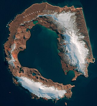
Deception Island is an island in the South Shetland Islands close to the Antarctic Peninsula with a large and usually "safe" natural harbor, which is occasionally troubled by the underlying active volcano. This island is the caldera of an active volcano, which seriously damaged local scientific stations in 1967 and 1969. The island previously held a whaling station. It is now a tourist destination with over 15,000 visitors per year. Two research stations are operated by Argentina and Spain during the summer season. While various countries have asserted sovereignty, it is still administered under the Antarctic Treaty System.

Beaufort Island is an island in Antarctica's Ross Sea. It is the northernmost feature of the Ross Archipelago, lying 21 kilometres north of Cape Bird, Ross Island. It is approximately 18.4 km2 in area. It was first charted by James Clark Ross in 1841. Ross named the island for Sir Francis Beaufort, hydrographer to the British Royal Navy.

The Aitcho Islands are a group of minor islands on the west side of the north entrance to English Strait separating Greenwich Island and Robert Island in the South Shetland Islands, Antarctica, which are situated between Dee Island to the south and Table Island to the north. The group is separated from Dee Island and Sierra Island to the southwest by Villalón Passage. The area was visited by early 19th century sealers operating from nearby Clothier Harbour. During the austral summer the islands are often visited by Antarctic cruise ships with tourists who land to watch wildlife.
This is a list of the flora of the South Sandwich Islands, a group of islands in the subantarctic Atlantic Ocean, part of the British overseas territory of South Georgia and the South Sandwich Islands. The list contains flora in the strict sense; that is, plants only. It comprises a single species of vascular plant, 38 mosses, and 11 liverworts. Unusually, not a single species is known to have naturalised on the islands; all are presumed native.

Dicranoweisia crispula, the mountain pincushion, is a species of mosses that lives at both poles. It grows in the South Shetland Islands and on the Antarctic Peninsula.

Coppermine Peninsula is the rugged, rocky promontory forming the northwest extremity of Alfatar Peninsula and Robert Island in the South Shetland Islands, Antarctica. It lies between the English Strait to the west and Carlota Cove to the east. It is 1.7 km long, 500 m wide and rising to 105 m.
The Joubin Islands are a group of small islands lying 6 kilometres (3 nmi) south-west of Cape Monaco, Anvers Island, at the south-western end of the Palmer Archipelago of Antarctica. The islands were discovered by the French Antarctic Expedition, 1903–05, under Jean-Baptiste Charcot, and named by him for Louis Joubin, the French naturalist. They have been designated a Restricted Zone under ASMA 7 — Southwest Anvers Island and Palmer Basin — which includes the marine area extending 50 metres (55 yd) from the shorelines.

The Guébriant Islands are two islands west of the Antarctic Peninsula, in the northern part of Marguerite Bay, lying 9.3 kilometres (5 nmi) southeast of Cape Alexandra, the southeast cape of Adelaide Island. They were discovered by the fourth French Antarctic Expedition 1908–1910 under Jean-Baptiste Charcot and named by him as "Îlots de Guébriant" after the Reverend Jean Budes de Guébriant, a French Catholic missionary to China.
Moe Island is an island 2 km (1.2 mi) long in the South Orkney Islands off Antarctica, separated from the south-west end of Signy Island by Fyr Channel. It was charted by Captain Petter Sørlle in 1912–13, and named after M. Thoralf Moe of Sandefjord, Norway, a contemporary whaling captain who worked in this area. The northernmost point of the island is Spaull Point, named by United Kingdom Antarctic Place-Names Committee (UK-APC) after Vaughan W. Spaull, British Antarctic Survey (BAS) biologist on Signy Island, 1969.
The Moss Islands are a group of small islands and rocks lying east of Midas Island and north of Apéndice Island in Hughes Bay, off the west coast of Graham Land, Antarctica. They were first charted in detail and given the descriptive name "Moos Inseln" by the Swedish Antarctic Expedition under Otto Nordenskiöld in 1902.
Lagotellerie Island is an island 1.9 kilometres (1 nmi) long, lying 3.7 kilometres (2 nmi) west of Horseshoe Island in Marguerite Bay, off the west coast of Graham Land, Antarctica. It was discovered and named by the French Antarctic Expedition, 1908–10, under Jean-Baptiste Charcot.

The Cierva Point and offshore islands Important Bird Area is a 6540 ha tract of land and sea on the Danco Coast of the Antarctic Peninsula.
New College Valley lies south of Cape Bird, on ice-free slopes above Caughley Beach on Ross Island, Antarctica. It faces north-west and carries meltwater from the Cape Bird ice cap during the summer. It is protected as Antarctic Specially Protected Area (ASPA) No.116 because it contains some of the richest stands of mosses, with associated microflora and fauna, in the Ross Sea region.
Green Island is one of the Berthelot Islands group, lying off the west coast of Graham Land, Antarctica.

Rhabdoweisiaceae is a family of haplolepideous mosses (Dicranidae) in the order Dicranales. It consists of 16 genera.
Dicranoweisia is a genus of mosses belonging to the family Rhabdoweisiaceae.

