Diesdorf

Last updated
Diesdorf
Diesdorf Klosterkirche2.jpg
Diesdorf: Monastery church
DE-ST 15-0-81-105 Diesdorf COA.png
Location of Diesdorf within Altmarkkreis Salzwedel district
Diesdorf in SAW.pngKalbeRohrberg
Germany adm location map.svg
Red pog.svg
Diesdorf
Saxony-Anhalt location map.svg
Red pog.svg
Diesdorf
Coordinates: 52°45′06″N10°52′31″E / 52.75156°N 10.87531°E / 52.75156; 10.87531
Country Germany
State Saxony-Anhalt
District Altmarkkreis Salzwedel
Municipal assoc. Beetzendorf-Diesdorf
Government
   Mayor (202229) Daniel Rieck [1]
Area
  Total100.52 km2 (38.81 sq mi)
Elevation
56 m (184 ft)
Population
 (2021-12-31) [2]
  Total2,292
  Density23/km2 (59/sq mi)
Time zone UTC+01:00 (CET)
  Summer (DST) UTC+02:00 (CEST)
Postal codes
29413
Dialling codes 03902
Vehicle registration SAW
Website www.diesdorf.de
Church in Mehmke Mehmke church.jpg
Church in Mehmke

Diesdorf is a municipality (Flecken) in the district Altmarkkreis Salzwedel, in Saxony-Anhalt, Germany.

Contents

Geography

Diesdorf is situated in the western Altmark about 5 km (3 mi) east of the border between Saxony-Anhalt and Lower Saxony, which between 1945 and 1990, was part of the inner German border, and about 25 km (16 mi) southwest of Salzwedel. The nearest major settlement in Lower Saxony is Wittingen at a distance of about 10 km (6 mi). The surrounding countryside is characterised by terminal moraines and sandy soils, which are mostly wooded. It was formed during the Saale stage of the middle Pleistocene.

Aside from the eponymous village, the municipality consists of the following districts: Abbendorf, Bergmoor, Dankensen, Dülseberg, Haselhorst, Höddelsen, Hohenböddenstedt, Hohengrieben, Lindhof, Mehmke, Molmke, Neuekrug, Peckensen, Reddigau, Schadeberg, Schadewohl, Waddekath, and Wüllmersen, [3] as well as the smaller settlements Forsthof Vier, Kerstenberg, Römke, and Schinkenmühle. Waddekath is located immediately east of the former inner German border.

The climate is relatively dry, with an average yearly precipitation of 622 mm, lower values being registered in only 25% of the weather stations of DWD. Precipitation is distributed fairly evenly over the year, with a difference of 1.6 between the wettest month (August) and the driest (October) and lower variations being registered only in 4% of the DWD weather stations.

History

Megalithic graves near Diesdorf, Molmke, and Schadeberg are evidence of the area having already been populated in the Upper Paleolithic era.

Diesdorf was first mentioned in 1112. The monastery Marienwerder of the Augustinian Canons, founded in 1161 by count Hermann of Warpke-Lüchow, had a major influence on the development of the village. After the Protestant Reformation and the secularisation of the monastery in 1551, the administration of a demesne of the state of Brandenburg and a noble women's convent were established in its place. Both were dissolved under the rule of the Kingdom of Westphalia in 1810.

After the return to Prussia, Diesdorf and the Altmark were integrated into the Magdeburg district of the Province of Saxony, from which the country of Saxony-Anhalt emerged in 1947. From 1952 to 1990 Diesdorf was part of Kreis Salzwedel in Bezirk Magdeburg .

Abbedorf and Waddekath were incorporated into Diesdorf on 1 January 1991 and Schadeberg followed on 1 November 1992. [4] The formerly independent municipality of Neuekrug was incorporated on 1 January 2010, and the municipality of Mehmke on 1 September 2010. [5]

The coat of arms was confirmed by the regional council in Magdeburg on 1 April 1997 and refers to the traditions of the Augustinian monastery and its role in the Christianisation of the area, symbolised by the black cross with golden borders, as well as to the location near the border of several lordships, symbolised by the rhombic pattern in the escutcheon which stands for a traditional border fence, but also for the pattern of the timber framework of the buildings. The oak leaves refer to the natural beauty of the countryside and the old oak trees along the monastery walls.

In 1998 the municipality was officially designated as a Flecken .

A storage facility for natural gas was built in a salt dome near Peckensen and has been substantially extended in 2014. [6]

Transportation

State road 8 between Wittingen and Salzwedel, part of tourist route German Timber-Frame Road, passes through Diesdorf, and state road 11 to Beetzendorf and Apenburg, part of tourist route Romanesque Road branches off in the centre of Diesdorf village. The railway lines to Salzwedel, Beetzendorf, and Wittingen were closed in 1993, 1973, and 1945, respectively.

Population and politics

Per the 2011 census, 41.1% of the then 2474 inhabitants were recorded as Protestants, 3.2% as Roman Catholics, the remaining 54.7% did not state any religion. [7]

After the elections of 7 June 2009, of the 12 seats in the municipal council were distributed as follows: CDU 3 seats, Die Linke 4 seats, SPD 4 seats, FDP 1 seat. [8]

Sights

Alte Darre, oast house of the former monastery Diesdorf Darre 2015.JPG
Alte Darre, oast house of the former monastery

Diesdorf is home to what is claimed to be the oldest open-air museum in Germany. Opened in 1911 by the local doctor, Goerg Schultze, the museum comprises more than 20 mostly timber-framed historical houses and farm buildings, as well as a post mill. [9] At the same time as creating the museum, the doctor also set up an adjacent open-air swimming pool.

The church St Mary and Crucis of the former monastery has been built in Brick Romanesque style. Construction started in 1182. Its neo-romanesque tower was added in 1863. Alte Darre, the old brewing and baking house of the former monastery dating back to the 14th century, has been restored in the early 2010s and is used as the local historical museum. The monastery walls are largely preserved.

Several megalithic graves are found in the municipal area. [10]

Related Research Articles

<span class="mw-page-title-main">Salzwedel</span> Town in Saxony-Anhalt, Germany

Salzwedel is a town in Saxony-Anhalt, Germany. It is the capital of the district (Kreis) of Altmarkkreis Salzwedel, and has a population of approximately 21,500. Salzwedel is located on the German Timber-Frame Road.

<span class="mw-page-title-main">Altmarkkreis Salzwedel</span> District in Saxony-Anhalt, Germany

Altmarkkreis Salzwedel is a district in Saxony-Anhalt, Germany. It is bounded by the districts Gifhorn, Uelzen, Lüchow-Dannenberg in Lower Saxony, and the districts of Stendal and Börde (district).

Stendal is a district in the north-east of Saxony-Anhalt, Germany. Its neighbouring districts are : Jerichower Land, Börde, Altmarkkreis Salzwedel, Lüchow-Dannenberg in Lower Saxony, and the districts of Prignitz, Ostprignitz-Ruppin and Havelland in Brandenburg.

<span class="mw-page-title-main">Arendsee</span> Town in Saxony-Anhalt, Germany

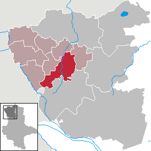
Arendsee is a town in the Altmarkkreis Salzwedel, Saxony-Anhalt, Germany. It is named after the lake Arendsee, located north of the town.

<span class="mw-page-title-main">Klötze</span> Town in Saxony-Anhalt, Germany

Klötze is a town in the Altmarkkreis Salzwedel (district), in Saxony-Anhalt, Germany. It is situated approximately 20 km northwest of Gardelegen, and 35 km northeast of Wolfsburg. It was mentioned first in 1144 with the name Cloetze, which means a wooden block. In January 2010, with the disbanding of the Verwaltungsgemeinschaft of Klötze, the town absorbed 11 former municipalities.

<span class="mw-page-title-main">Flechtingen</span> Municipality in Saxony-Anhalt, Germany

Flechtingen is a municipality in the Börde district in Saxony-Anhalt, Germany. It is situated approximately 35 km northwest of Magdeburg. On 1 January 2010 it absorbed the former municipalities Behnsdorf, Belsdorf and Böddensell.

<span class="mw-page-title-main">Niedere Börde</span> Municipality in Saxony-Anhalt, Germany

Niedere Börde is a municipality in the Börde district in Saxony-Anhalt, Germany. It is situated between Haldensleben and Magdeburg. It was formed in January 2004 by the merger of the former municipalities Dahlenwarsleben, Groß Ammensleben, Gutenswegen, Jersleben, Klein Ammensleben, Meseberg, Samswegen and Vahldorf.

<span class="mw-page-title-main">Seehausen, Altmark</span> Town in Saxony-Anhalt, Germany

Seehausen is a town in the district of Stendal, in Saxony-Anhalt, Germany. It is situated approximately 30 km (19 mi) north of Stendal in the Altmark, a historic region in Germany, comprising the northern third of Saxony-Anhalt. In January 2010 it absorbed the former municipalities Beuster, Geestgottberg and Losenrade, and in September 2010 Schönberg.

<span class="mw-page-title-main">Tangerhütte</span> Town in Saxony-Anhalt, Germany

Tangerhütte is a town in the district of Stendal, in Saxony-Anhalt, Germany. It has a population of 10,612 (2020) and is situated on the river Tanger, approximately 20 km south of Stendal.

<span class="mw-page-title-main">Calvörde</span> Municipality in Saxony-Anhalt, Germany

Calvörde is a municipality in the Börde district of Saxony-Anhalt, Germany. It is part of the Verbandsgemeinde Flechtingen.

<span class="mw-page-title-main">Schönhausen</span> Municipality in Saxony-Anhalt, Germany

Schönhausen is a municipality in the district of Stendal in Saxony-Anhalt in Germany. It is the seat of the Verbandsgemeinde Elbe-Havel-Land.

Börde is a district in Saxony-Anhalt in Germany. Its seat is the town Haldensleben. It takes its name from the natural region Magdeburg Börde. It is the site of the Morsleben radioactive waste repository. The disposal of waste into the facility ended in 1998.

<span class="mw-page-title-main">Rohrberg, Saxony-Anhalt</span> Municipality in Saxony-Anhalt, Germany

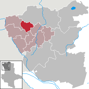
Rohrberg is a municipality in the district Altmarkkreis Salzwedel, in Saxony-Anhalt, Germany. Since January 2009, it includes the former municipalities of Ahlum and Bierstedt.

<span class="mw-page-title-main">Beetzendorf</span> Municipality in Saxony-Anhalt, Germany

Beetzendorf is a municipality in the district Altmarkkreis Salzwedel, in Saxony-Anhalt, Germany. It consists of the following Ortsteile or municipal divisions:

<span class="mw-page-title-main">Dähre</span> Municipality in Saxony-Anhalt, Germany

Dähre is a municipality in the district Altmarkkreis Salzwedel, in Saxony-Anhalt, Germany. A section of the Salzwedeler Dumme river flows through it. Since 2009 it has incorporated the former municipalities of Bonese and Lagendorf.

<span class="mw-page-title-main">Jübar</span> Municipality in Saxony-Anhalt, Germany

Jübar is a municipality in the district Altmarkkreis Salzwedel, in Saxony-Anhalt, Germany. Since 1 January 2010 it has incorporated the former municipalities of Bornsen, Hanum, Lüdelsen and Nettgau.

<span class="mw-page-title-main">Kuhfelde</span> Municipality in Saxony-Anhalt, Germany

Kuhfelde is a municipality in the district Altmarkkreis Salzwedel, in Saxony-Anhalt, Germany. Since 2009 it has included the former municipalities of Püggen, Siedenlangenbeck and Valfitz.

<span class="mw-page-title-main">Wallstawe</span> Municipality in Saxony-Anhalt, Germany

Wallstawe is a municipality in the district Altmarkkreis Salzwedel, in Saxony-Anhalt, Germany. Since July 2009 it has included the former municipalities of Ellenberg and Gieseritz.

<span class="mw-page-title-main">Am Großen Bruch</span> Municipality in Saxony-Anhalt, Germany

Am Großen Bruch is a municipality in the Börde district in Saxony-Anhalt, Germany. It is part of the Verbandsgemeinde Westliche Börde. The municipality was created on 1 July 2004 by the merger of the former municipalities Gunsleben, Hamersleben and Neuwegersleben. On 1 January 2010 it absorbed the former municipality Wulferstedt.

<span class="mw-page-title-main">Apenburg-Winterfeld</span> Municipality in Saxony-Anhalt, Germany

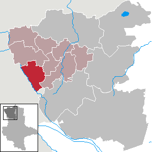
Apenburg-Winterfeld is a municipality in the district Altmarkkreis Salzwedel, in Saxony-Anhalt, Germany. It was formed by the merger of the previously independent municipalities Apenburg, Winterfeld and Altensalzwedel, on 1 July 2009.

References

  1. Bürgermeisterwahlen in den Gemeinden, Endgültige Ergebnisse, Statistisches Landesamt Sachsen-Anhalt, accessed 10 November 2022.
  2. "Bevölkerung der Gemeinden – Stand: 31. Dezember 2021" (PDF) (in German). Statistisches Landesamt Sachsen-Anhalt. June 2022.
  3. "Hauptsatzung des Flecken Diesdorf" (PDF). 31 March 2015.
  4. Statistisches Bundesamt (1995). Gemeinden 1994 und ihre Veränderungen seit 01.01.1948 in den neuen Ländern. Stuttgart: Metzler-Poeschel. pp. 361ff. ISBN   3-8246-0321-7.
  5. Gebietsänderungen vom 01. Januar bis 31. Dezember 2010, Statistisches Bundesamt
  6. "Erdgasspeicher Peckensen" (in German). Storenery Deutschland. Archived from the original on 3 March 2018. Retrieved 13 March 2017.
  7. "Bevölkerung nach Geschlecht und Religion". Zensus 2011. 9 May 2011. Archived from the original on 5 June 2013. Retrieved 13 March 2017.
  8. "Gemeinde Flecken Diesdorf - Altmarkkreis Salzwedel. Endgültiges Ergebnis" (in German). Statistisches Landesamt Sachsen-Anhalt. 1 June 2010.
  9. "Freilichtmuseum Diesdorf". Museen des Altmarkkreises Salzwedel, Molmker Straße 23 D-29413 Diesdorf/ Altmark. Retrieved 7 May 2015.
  10. Reinhard Möws (8 October 2016). "Die Großsteingräber der Altmark".