
Mount Bogong,, located in the Alpine National Park and part of the Victorian Alps of the Great Dividing Range, is the highest mountain in Victoria, Australia, at 1,986 metres (6,516 ft) above sea level.

The Victorian Alps, also known locally as the High Country, is a large mountain system residing in the southeastern Australian state of Victoria. Occupying the majority of eastern Victoria, it is the southwestern half of the Australian Alps, the tallest portion of the Great Dividing Range. The Yarra and Dandenong Ranges, both sources of rivers and drinking waters for Melbourne, are branches of the Victorian Alps.

Bright is a town in northeastern Victoria, Australia, 319 metres above sea level at the southeastern end of the Ovens Valley. At the 2016 census, Bright had a population of 2,406. It is in the Alpine Shire local government area. Its postcode is 3741.
East Gippsland is the eastern region of Gippsland, Victoria, Australia covering 31,740 square kilometres (14%) of Victoria. It has a population of 80,114.
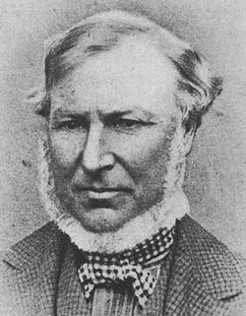
Angus McMillan was a Scottish-born explorer, pioneer pastoralist, and perpetrator of several of the Gippsland massacres of Gunai people.

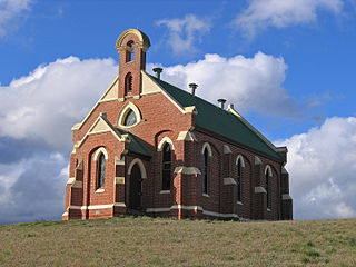
Omeo is a town in Victoria, Australia on the Great Alpine Road, east of Mount Hotham, in the Shire of East Gippsland. At the 2016 census, Omeo had a population of 406. The name is derived from an Aboriginal word for 'mountains' or 'hills'. Omeo is affectionately known as the City of the Alps with many historic buildings remaining in the town. The town is still the commercial hub for the Omeo Region and is a service centre for outlying communities such as Benambra, Cobungra, Cassilis, Swifts Creek, and Ensay.
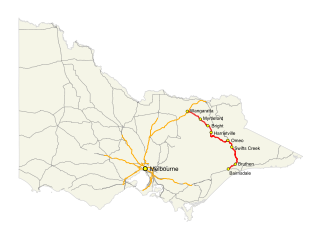
The Great Alpine Road (B500) is a country tourist road in Victoria, Australia, running from Wangaratta in the north to Bairnsdale in the east, and passing through the Victorian Alps. The road was given its current name because it was considered the mountain equivalent to Victoria's world-famous Great Ocean Road in the south-west of the state. The road usually remains open during winter; however, vehicles travelling between Harrietville and Omeo are required to carry diamond-pattern snow chains during the declared snow season.
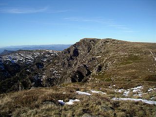
Mount Howitt, also known as Toot-buck-nulluck in the Gunai language, is a mountain in Victoria, Australia, named for Alfred William Howitt. Located in the Wonangatta Moroka Unit of the Alpine National Park approximately 170 km north-east of Melbourne.
Benambra is a small town 28 kilometres (17 mi) north-east of Omeo and 430 kilometres (267 mi) east of the state capital Melbourne, in the Australian Alps of East Gippsland, Victoria, Australia. Nearby towns include Swifts Creek, Ensay, and the major town of Bairnsdale. At the 2016 census, Benambra and the surrounding area had a population of 149.

Bruthen is a small town located alongside the Tambo River between Bairnsdale and Ensay on the Great Alpine Road in East Gippsland, Victoria, Australia. At the 2016 census, Bruthen had a population of 814. Bruthen is 26 km (16 mi) east of Bairnsdale and 311 km (193 mi) east of the state capital Melbourne.

The Tambo River or Berrawan is a perennial river of the Mitchell River catchment, located in the East Gippsland region of the Australian state of Victoria. With a total length in excess of 186 kilometres (116 mi), the Tambo River is one of the longest rivers in the East Gippsland drainage basin, extending from the steep forested southern slopes of the Victorian Alps through forest and farmland to the Gippsland Lakes.

The Howqua River, a minor inland perennial river of the Goulburn Broken catchment, part of the Murray-Darling basin, is located in the alpine region of the Australian state of Victoria. The headwaters of the Howqua River rise below Mount Howitt in the western slopes of the Victorian Alps, and descend to flow into the Goulburn River within Lake Eildon.

Tambo Crossing is a locality and small farming community in the Shire of East Gippsland in Victoria, Australia. It is alongside the Tambo River on the Great Alpine Road, 57.5 kilometres (35.7 mi) north-east of Bairnsdale, surrounded by state forest. At the 2006 census, Tambo Crossing had a nominal population.

The Ngarigo are an Aboriginal Australian people of southeast New South Wales, whose traditional lands also extend around the present border with Victoria.
The Krauatungalung are an Indigenous Australian people, of East Gippsland, in the state of Victoria, Australia. They are regarded as a group of the Kurnai, though Tindale states that their inclusion as one of the Gunai is artificial.
The Minjambuta were an Indigenous Australian tribe of northern Victoria.
The Dhudhuroa people are an Indigenous Australian people of North-eastern Victoria, in the state of Victoria, Australia. About 2,000 descendants exist in Australia in the early 21st century.
The Tatungalung are an indigenous Australian people of the state of Victoria. They are often, together with the Bratauolung, Braiakaulung, Brabiralung and Krauatungalung classified as belonging to one nation, the Gunai/Kurnai, though this typology has been thought, by Norman Tindale, to be an artificial construct.
The Jaitmatang, also spelled Yaithmathang, were an Indigenous Australian people of the State of Victoria.
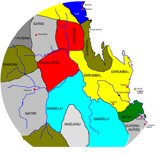
The Koinmerburra people, also known as Koinjmal, Guwinmal, Kungmal and other variants, are an Aboriginal Australian people of the state of Queensland. They are the traditional owners of an area which includes part of the Great Barrier Reef.
HOWITT, A. W. 1904 The native tribes of South Eastern Australia. MacMillan, London. (Aboriginal Studies Press reprint 1996). GUNN, R. G. 2002 Mudgegonga 2 and the Rock Art of North East Victoria. Rock Art Research 19: 1–17.


