The Continental Divide National Scenic Trail is a United States National Scenic Trail with a length measured by the Continental Divide Trail Coalition of 3,028 miles (4,873 km) between the U.S. border with Chihuahua, Mexico and the border with Alberta, Canada. Frequent route changes and a large number of alternate routes result in an actual hiking distance of 2,700 miles (4,300 km) to 3,150 miles (5,070 km). The CDT follows the Continental Divide of the Americas along the Rocky Mountains and traverses five U.S. states — Montana, Idaho, Wyoming, Colorado, and New Mexico. In Montana near the Canadian border the trail crosses Triple Divide Pass.
Mount Dana is a mountain in the U.S. state of California. Its summit marks the eastern boundary of Yosemite National Park and the western boundary of the Ansel Adams Wilderness. At an elevation of 13,061 feet (3,981 m), it is the second highest mountain in Yosemite, and the northernmost summit in the Sierra Nevada which is over 13,000 feet (3,962.4 m) in elevation. Mount Dana is the highest peak in Yosemite that accessible to summit. The mountain is named in honor of James Dwight Dana, who was a professor of natural history and geology at Yale.

Mount Katahdin is the highest mountain in the U.S. state of Maine at 5,269 feet (1,606 m). Named Katahdin, which means "Great Mountain", by the Penobscot Native Americans, it is within Northeast Piscataquis, Piscataquis County, and is the centerpiece of Baxter State Park. It is a steep, tall massif formed from a granite intrusion weathered to the surface. The flora and fauna on the mountain are typical of those found in northern New England, with the summit hosting fragile and endangered alpine tundra.

The Taconic Mountains are a 150-mile-long sub-range of the Appalachian Mountains lying on the eastern border of New York State and adjacent New England. The range, which played a role in the history of geological science, is separated from the Berkshires and Green Mountains to the east by a series of valleys, principally those of the Housatonic River, Battenkill River and Otter Creek. The Taconics' highest point is Mount Equinox in Vermont at 3,840 feet (1,170 m); among many other summits are Dorset Mountain, Mount Greylock and Mount Everett.

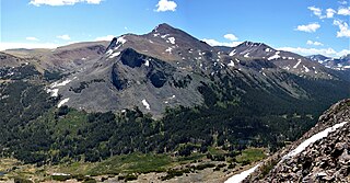
Mount Harvard is the third highest summit of the Rocky Mountains of North America and the U.S. state of Colorado. The prominent 14,421-foot (4395.6 m) fourteener is the highest summit of the Collegiate Peaks and the fourth highest summit in the contiguous United States. Mount Harvard is located in the Collegiate Peaks Wilderness of San Isabel National Forest, 11.7 miles (18.9 km) northwest by west of the Town of Buena Vista in Chaffee County, Colorado, United States. The summit of Mount Harvard is the highest point in Chaffee County and is higher than any point in the United States east of its longitude. The mountain was named in honor of Harvard University.

Santa Fe Baldy is a prominent summit in the Sangre de Cristo Mountains of New Mexico, United States, located 15 mi (24 km) northeast of Santa Fe. There are no higher mountains in New Mexico south of Santa Fe Baldy. It is prominent as seen from Los Alamos and communities along the Rio Grande in northern New Mexico, but is relatively inconspicuous from Santa Fe, as its north-south trending main ridge line is seen nearly end-on, disguising the size of the mountain. Tree line in the Sangre de Cristos is unusually high and only the top 600 to 800 feet of the mountain is perpetually free of trees, but several severe forest fires have created bare spots extending to lower elevations. An extensive region of aspen trees on its flanks produces spectacular orange-yellow coloration during the fall that is the subject of many photographic studies.
Hurricane Ridge is a mountainous area in Washington's Olympic National Park. Approximately 18 miles (29 km) by road from Port Angeles, the ridge is open to hiking, skiing, and snowboarding and is one of the two most visited sites in the national park.

Squak Mountain is the second most westerly mountain of the Issaquah Alps mountain chain in Washington state. It is situated between Cougar Mountain to the west and Tiger Mountain to the east. Interstate 90 parallels the base of the north side of the mountain. Much of the Squak Mountain watershed drains into Lake Sammamish. Most of the mountain is protected by Squak Mountain State Park and the Cougar/Squak and Squak/Tiger Corridors of King County.

Tiger Mountain is a mountain in the U.S. state of Washington. It is at the center of the Issaquah Alps, a small range in the Eastside region of King County, Washington southeast of Seattle. The mountain is part of a designated protected area, the Tiger Mountain State Forest, and has several recreational areas used for hiking, mountain biking, and paragliding.

Telescope Peak is the highest point within Death Valley National Park, in the U.S. state of California. It is also the highest point of the Panamint Range, and lies in Inyo County. From atop this desert mountain one can see for over one hundred miles in many directions, including west to Mount Whitney, and east to Charleston Peak. The mountain was named for the great distance visible from the summit.
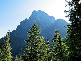
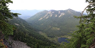
Baring Mountain, is a peak in the central part of the Cascade Range of Washington, United States. It lies about 2 miles (3.2 km) northeast of the Skykomish River and US Highway 2, at the western edge of the Cascades in the Mount Baker-Snoqualmie National Forest. It is about 6 miles (9.7 km) east of Mount Index and Barclay Lake at its base is accessible via Forest Road 6024 and a 2.2-mile (3.5 km) hike.

Kendrick Peak or Kendrick Mountain is one of the highest peaks in the San Francisco volcanic field north of the city of Flagstaff in the U.S. state of Arizona and is located on the Coconino Plateau in Coconino County.

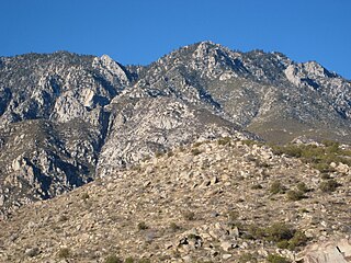
Miller Peak, at 9,470 feet (2,886 m), is the second-highest mountain in Cochise County, Arizona. Located approximately 10 miles south of Sierra Vista, Arizona, it is the highest mountain in the Huachuca mountain range and a popular local hiking destination. The Miller Peak Wilderness encompasses 20,190 acres and is managed by the Coronado National Forest. This is also the most southerly peak and land area to rise above 9,000 feet in the continental United States. The area was affected by the 2011 Monument fire and most of the pine trees seen in older photographs were burned and destroyed. Scrub oak are beginning to replace the areas that were previously covered by pine.

The Enchantments is a region within the Alpine Lakes Wilderness area of Washington state's Cascade Mountain Range. At an elevation of 4,500 feet, it is home to over 700 alpine lakes and ponds surrounded by the vast peaks of Cashmere Crags, which rate among the best rock-climbing sites in the western United States. The highest peak, Dragontail Peak, stretches 8,840 feet high. The Enchantments is located 15 miles southwest of the popular Bavarian-themed town Leavenworth, Washington in the United States and is regarded as one of the most spectacular regions in the Cascade Range.

Balsam Mountain is one of the High Peaks of the Catskill Mountains in the U.S. state of New York. Its exact height has not been determined, so the highest contour line, 3,600 feet (1,100 m), is usually given as its elevation. It is located in western Ulster County, on the divide between the Hudson and Delaware watersheds. The summit and western slopes of the peak are within the Town of Hardenburgh and its eastern slopes are in Shandaken. The small community of Oliverea is near its base on that side. Most of the mountain is publicly owned, managed by the New York State Department of Environmental Conservation as part of the state Forest Preserve, part of the Big Indian-Beaverkill Range Wilderness Area in the Catskill Park. The summit is on a small corner of private land.

Balsam Lake Mountain is one of the Catskill Mountains, located in the Town of Hardenburgh, New York, United States. It is the westernmost of the range's 35 High Peaks. Its exact height has not been determined, but the highest contour line on topographic maps, 3,720 feet (1,130 m), is usually given as its elevation.

The Huachuca Mountains are part of the Sierra Vista Ranger District of the Coronado National Forest in Cochise County in southeastern Arizona, approximately 70 miles (110 km) south-southeast of Tucson and southwest of the city of Sierra Vista. Included in this area is the highest peak in the Huachucas, Miller Peak, and the region of the Huachucas known as Canelo Hills in eastern Santa Cruz County. The mountains range in elevation from 3,934 feet (1,199 m) at the base to 9,466 feet (2,885 m) at the top of Miller Peak. The second highest peak in this range is Carr Peak, elevation 9,200 feet (2,804 m). The Huachuca Mountain area is managed principally by the United States Forest Service (41%) and the U.S. Army (20%), with much of the rest being private land (32%). Sierra Vista is the main population center.

Buckner Mountain is a tall peak in the North Cascades of Washington state and in the Stephen Mather Wilderness of North Cascades National Park. At 9,114 feet (2,778 m) in elevation it is the highest in Skagit County and one of about ten of Washington's non-volcanic peaks above 9,000 feet high. It is ranked as the 14th highest peak in the state, and the third highest peak in North Cascades National Park.
The Cactus to Clouds Trail (C2C) is a hiking route in California. It begins in Palm Springs, California, and ascends to San Jacinto Peak. With a net elevation gain of roughly 10,300 feet (3,100 m), it has one of the greatest elevation increases among day-hike routes in the United States. The elevation gain happens in only 16 miles (26 km), also making it one of the steeper trails of its length in the world. The trail runs roughly parallel to the Palm Springs Aerial Tramway, and the upper part of the trail runs very close to the Mountain station of the tramway.

Mailbox Peak is a 4,841-foot-elevation (1,476 m) mountain located in King County of Washington state. It is set west of the crest of the Cascade Range, on land managed by Mount Baker-Snoqualmie National Forest. Mailbox Peak is situated seven miles east of North Bend, and one mile northeast above the Washington State Fire Training Academy. Precipitation runoff from the south side of the mountain drains into the South Fork Snoqualmie River, whereas the north side drains to the Middle Fork of the Snoqualmie. The summit lies along a ridge containing Dirtybox Peak, its topographical parent, and Dirty Harry's Peak. Topographic relief is significant as the northwest aspect rises nearly 4,100 feet above the Middle Fork in 1.25 mile. The popular Mailbox Peak Trail gains 4,100 feet of elevation over 5.5 miles. Prior to 2014 when the new trail was completed, climbing Mailbox Peak involved 4,000 feet gain in only 2.6 miles along an unmaintained route that was used for conditioning for major climbs, and recruits from the Fire Training Academy would celebrate graduation by carrying a fire hydrant to the summit. The peak is named for a mailbox at the top which functions as the summit register, but this toponym has not been officially adopted by the U.S. Board on Geographic Names.