Districts and neighbourhoods of Warsaw

Last updated

Districts of Warsaw (since 2002) Warszawa podzial administracyjny 2002.svg
Districts of Warsaw (since 2002)

Warsaw is a city with powiat rights, and is further divided into 18 districts ( dzielnica pronounced [ˈd͡ʑɛlɲit͡sa] ), auxiliary units which are legally integral parts of the city as an entity, but with some limited powers devolved to their own local governments (or ‘self-governments’ as they are typically referred to in Polish).

Contents

The current division into quarters was established in 2002. The 18 districts are informally divided broadly into the inner and outer city quarters, as follows:

Districts of Warsaw

DistrictPopulationArea
Mokotów 220,68235.4 km2 (13.7 sq mi)
Praga-Południe 178,66522.4 km2 (8.6 sq mi)
Ursynów 145,93848.6 km2 (18.8 sq mi)
Wola 137,51919.26 km2 (7.44 sq mi)
Bielany 132,68332.3 km2 (12.5 sq mi)
Targówek 123,27824.37 km2 (9.41 sq mi)
Śródmieście 122,64615.57 km2 (6.01 sq mi)
Bemowo 115,87324.95 km2 (9.63 sq mi)
Białołęka 96,58873.04 km2 (28.20 sq mi)
Ochota 84,99009.7 km2 (3.7 sq mi)
Wawer 69,89679.71 km2 (30.78 sq mi)
Praga-Północ 69,51011.4 km2 (4.4 sq mi)
Ursus 53,75509.35 km2 (3.61 sq mi)
Żoliborz 48,34208.5 km2 (3.3 sq mi)
Włochy 38,07528.63 km2 (11.05 sq mi)
Wilanów 23,96036.73 km2 (14.18 sq mi)
Rembertów 23,28019.30 km2 (7.45 sq mi)
Wesoła 22,81122.6 km2 (8.7 sq mi)
Total1,708,491 [1] 521.81 km2 (201.47 sq mi)

Neighbourhoods

Each of the districts is customarily subdivided into several smaller areas, known under the designation of a neighbourhood ( osiedle ), a unit with no legal or administrative powers, used for statistics or as a designation within the city localization system (Miejski System Informacji).

BemowoBiałołękaBielany
  • Bemowo Lotnisko
  • Boernerowo
  • Chrzanów
  • Fort Bema
  • Fort Radiowo
  • Górce
  • Groty
  • Jelonki Północne
  • Jelonki Południowe
  • Lotnisko
  • Białołęka Dworska
  • Brzeziny
  • Choszczówka
  • Dąbrówka Szlachecka
  • Grodzisk
  • Henryków
  • Kobiałka
  • Nowodwory
  • Szamocin
  • Tarchomin
  • Żerań
  • Chomiczówka
  • Huta
  • Las Bielański
  • Młociny
  • Marymont-Kaskada
  • Marymont-Ruda
  • Piaski
  • Placówka
  • Radiowo
  • Słodowiec
  • Stare Bielany
  • Wólka Węglowa
  • Wawrzyszew
  • Wrzeciono
MokotówOchotaPraga-Południe
  • Augustówka
  • Czerniaków
  • Ksawerów
  • Służew
  • Służewiec
  • Sadyba
  • Siekierki
  • Sielce
  • Stary Mokotów
  • Stegny
  • Wierzbno
  • Wyględów
  • Filtry
  • Rakowiec
  • Stara Ochota
  • Szczęśliwice
  • Gocław
  • Gocławek
  • Grochów
  • Kamionek
  • Olszynka Grochowska
  • Saska Kępa
Praga-PółnocRembertówŚródmieście
  • Nowa Praga
  • Pelcowizna
  • Stara Praga
  • Szmulowizna
  • Kawęczyn-Wygoda
  • Nowy Rembertów
  • Stary Rembertów
  • Muranów
  • Nowe Miasto
  • Powiśle
  • Solec
  • Stare Miasto
  • Śródmieście Północne
  • Śródmieście Południowe
  • Ujazdów
TargówekUrsusUrsynów
  • Elsnerów
  • Bródno
  • Bródno Podgrodzie
  • Targówek Fabryczny
  • Targówek Mieszkaniowy
  • Zacisze
  • Utrata
  • Czechowice
  • Gołąbki
  • Niedźwiadek
  • Skorosze
  • Szamoty
  • Dąbrówka
  • Grabów
  • Jeziorki Północne
  • Jeziorki Południowe
  • Kabaty
  • Natolin
  • Pyry
  • Skarpa Powsińska
  • Stary Służew
  • Stary Imielin
  • Teren Wydzielony Rezerwat „Las Kabacki”
  • Ursynów Centrum
  • Ursynów Północny
  • Wyczółki
WawerWesołaWilanów
  • Aleksandrów
  • Anin
  • Falenica
  • Las
  • Marysin Wawerski
  • Miedzeszyn
  • Międzylesie
  • Nadwiśle
  • Radość
  • Sadul
  • Wawer
  • Zerzeń
  • Groszówka
  • Plac Wojska Polskiego
  • Stara Miłosna
  • Wesoła-Centrum
  • Wola Grzybowska
  • Zielona-Grzybowa
  • Wilanów Wysoki
  • Wilanów Niski
  • Wilanów Królewski
  • Błonia Wilanowskie
  • Powsinek
  • Zawady
  • Kępa Zawadowska
  • Powsin
WłochyWolaŻoliborz
  • Nowe Włochy
  • Okęcie
  • Opacz Wielka
  • Paluch
  • Raków
  • Salomea
  • Stare Włochy
  • Załuski
  • Czyste
  • Koło
  • Młynów
  • Mirów
  • Nowolipki
  • Odolany
  • Powązki
  • Ulrychów
  • Marymont-Potok
  • Stary Żoliborz
  • Sady Żoliborskie

History

1994-2002

No. [2] District
1Warszawa-Bemowo
2Warszawa-Białołęka
3Warszawa-Bielany
4Warszawa-Centrum
5Warszawa-Rembertów
6Warszawa-Targówek
7Warszawa-Ursus
8Warszawa-Ursynów
9Warszawa-Wawer
10Warszawa-Wilanów
11Warszawa-Włochy

1990-1994

Warsaw in 1990-1993 Warszawa 1990-1993.jpg
Warsaw in 1990-1993
No. [2] District
1Mokotów
2Ochota
3Praga-Południe
4Praga-Północ
5Śródmieście
6Ursus (1993-1994)
7Wola
8Żoliborz

1959–1990

No. [2] District
1Śródmieście
2Żoliborz
3Wola
4Ochota
5Mokotów
6Praga Północ
7Praga Południe

1951/1952–1959

No. [2] District
1Warszawa Śródmieście
2Warszawa Stare Miasto
3Warszawa Żoliborz
4Warszawa Wola
5Warszawa Ochota
6Warszawa Mokotów
7Warszawa Wilanów
8Warszawa Praga Śródmieście
9Warszawa Praga Północ
10Warszawa Praga Południe
11Warszawa Wawer

Coats of arms

Some, but not all of the districts use specific coats of arms.

POL gmina Bialoleka COA.svg Białołęka Warsaw district Praga coa.png Praga-Północ POL Wawer COA.svg Wawer
POL Warszawa-Bielany COA.svg Bielany POL gmina Rembertow COA.svg Rembertów Warsaw district Wesola coa.png Wesoła
Herb-dzielnicy-Bemowo-Warszawa.jpg Bemowo POL COA blank.svg Śródmieście POL Wilanow (Warszawa) COA.svg Wilanów
Mokotow.svg Mokotów POL Targowek COA.svg Targówek POL Warszawa-Wlochy COA.jpg Włochy
POL COA blank.svg Ochota POL COA blank.svg Ursus POL COA blank.svg Wola
Warsaw district Praga coa.png Praga-Południe POL Warszawa-Ursynow COA.svg Ursynów POL COA blank.svg Żoliborz

Related Research Articles

<span class="mw-page-title-main">Praga</span> Place in Masovian Voivodeship, Poland

Praga is a district of Warsaw, Poland. It is on the east bank of the river Vistula. First mentioned in 1432, until 1791 it formed a separate town with its own city charter.

<span class="mw-page-title-main">Downtown, Warsaw</span> Major district in Warsaw, Poland

The Downtown is a district of the city of Warsaw, Poland.

<span class="mw-page-title-main">Rembertów</span> District of Warsaw, Poland

Rembertów is a district of the city of Warsaw, the capital of Poland. Between 1939 and 1957 Rembertów was a separate town, after which it was incorporated as part of the borough of Praga-Południe. Between 1994 and 2002 it formed a separate commune of Warszawa-Rembertów. In the 1940s it was a site of a prison operated first by Nazis and then by Soviets.

<span class="mw-page-title-main">Białołęka</span> Dzielnica of Warsaw in Masovian Voivodeship, Poland

Białołęka is one of 18 districts of Warsaw, located in the northern part of the city. Until October 27, 2002 Białołęka was a gmina.

<span class="mw-page-title-main">Bielany</span> Warsaw District in Masovian Voivodeship, Poland

Bielany is a district in Warsaw located in the north-western part of the city.

<span class="mw-page-title-main">Praga-North</span> Warsaw District in Masovian Voivodeship, Poland

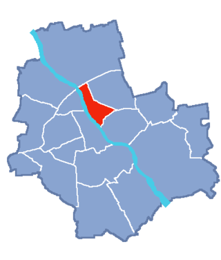
Praga-North, also known as North Praga, Praga North, is a district of the city of Warsaw, Poland, located in the central part of the city.

<span class="mw-page-title-main">Targówek</span> Warsaw District in Masovian Voivodeship, Poland

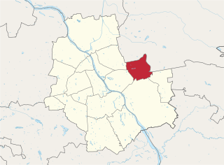
Targówek is a district in Warsaw, Poland located in the northern part of the city.

<span class="mw-page-title-main">Wawer</span> Warsaw District in Masovian Voivodeship, Poland

Wawer is one of the districts of Warsaw, located in the south-eastern part of the city. The Vistula river runs along its western border. Wawer became a district of Warsaw on 27 October 2002.

<span class="mw-page-title-main">Włochy</span> Warsaw District in Masovian Voivodeship, Poland

Włochy is one of the districts of Warsaw, located in the south-western part of city. Włochy borders districts Bemowo and Wola from the north, Ochota and Mokotów from the east, and Ursus and Ursynów from the south.

The District of Warsaw (of Armia Krajowa) (Polish: Okręg Warszawa) - one of territorial organisational units of Polish Home Army, which covered the territory of Warsaw and its close neighbourhood i.e. the Powiat of Warsaw. Military units belonging to that district took part in the Warsaw Uprising of 1944.

<span class="mw-page-title-main">Warsaw County Subdistrict (Home Army)</span>

The Sub-district VII of Warsaw suburbs also called Sub-district collar - a territorial organisational unit of the District of Warsaw of Armia Krajowa, which acted during the German occupation of Poland. Military units of that sub-district took part in the Warsaw Uprising of 1944.

<span class="mw-page-title-main">Architecture of Warsaw</span> Overview of the architecture of Warsaw

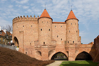
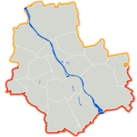
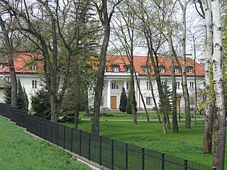
The architecture of Warsaw has influenced and reflected the history of Polish architecture. The city of Warsaw features prominent buildings in a variety of styles by many important architects. Warsaw's palaces, churches and mansions display a richness of color and architectural details.

<span class="mw-page-title-main">Veturilo</span>

Veturilo is a public bicycle sharing system in Warsaw, Poland, launched on 1 August 2012 with 55 stations and 1000 bicycles in 3 districts - Śródmieście, Bielany and Ursynów, 2 other stations started operating in the middle of August in Wilanów. It is the biggest public bicycle sharing system in Poland and the fifth largest in Europe. It is also considered one of the most successful bike sharing systems in the world.

<span class="mw-page-title-main">Timeline of Warsaw</span>

The following is a timeline of the history of Warsaw in Poland.

<span class="mw-page-title-main">Miasto Jest Nasze</span> Warsaw-baed non-profit civic association

Miasto Jest Nasze is an independent citizen platform launched in 2013 in Warsaw, as of 2014 registered as a non-profit civic association. Miasto Jest Nasze is considered to be one of the major urban movements in Poland. In 2018 Polish local elections coalition formed by Miasto Jest Nasze took 22 seats in Warsaw district councils.

<span class="mw-page-title-main">Grochowska Street, Warsaw</span> Street in Warsaw

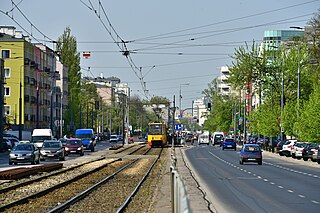
Grochowska Street is a major road located in the Praga Południe district of Warsaw, Poland. Since November 1, 1925, a tram route has run along Grochowska Street. Currently trams and many bus lines connect Praga with Śródmieście, Wola, Rembertów and Wawer.

The Warsaw County was the county of the Masovian Voivodeship, Poland, consisting of the city of Warsaw, that existed from 1 January 1999 to 27 October 2002. It had an area of 536.5 km2.

<span class="mw-page-title-main">Senate Constituency no. 42</span> Parliamentary constituency in Poland

Senate Constituency no. 42 is a single-member constituency for the Senate of Poland comprising five districts of the city of Warsaw: Praga-Południe, Praga-Północ, Rembertów, Targówek, Wesoła. Incumbent senator is Marek Borowski elected in 2023 parliamentary election. He has held the seat for four terms in a row since the constituency was established in 2011.

References

  1. "Ludność w gminach według stanu w dniu 31.12.2011 r. bilans opracowany w oparciu o wyniki NSP'2011" (in Polish). Glówny Urząd Statystyczny. Archived from the original on 17 August 2012. Retrieved 21 August 2012.
  2. 1 2 3 4 Gawryszewski, Andrzej. (2009). Ludność Warszawy w XX wieku. Warszawa: PAN IG i PZ. ISBN   978-83-61590-96-5. OCLC   610002771.