Djigoue | |
|---|---|
 Djigoue Department location in the province | |
| Country | |
| Province | Poni Province |
| Time zone | UTC+0 (GMT 0) |
Djigoue is a department or commune of Poni Province in southern Burkina Faso. Its capital lies at the town of Djigoue. [1]
Djigoue | |
|---|---|
| Djigoue Department location in the province | |
| Country | |
| Province | Poni Province |
| Time zone | UTC+0 (GMT 0) |
Djigoue is a department or commune of Poni Province in southern Burkina Faso. Its capital lies at the town of Djigoue. [1]
| | This section is empty. You can help by adding to it. (July 2010) |

Gloverville is a census-designated place (CDP) in Aiken County, South Carolina, United States. The population was 2,831 at the 2010 census. It is part of the Augusta, Georgia metropolitan area. Gloverville is located in historic Horse Creek Valley.

Beaumont Provincial Park is a provincial park located at the southeast end of Fraser Lake, between Fort Fraser and the town of Fraser Lake, British Columbia, approximately 40 km west of Vanderhoof, British Columbia. The park contains the site of the original Fort Fraser.
Dixie Cove Marine Provincial Park, originally Dixie Cove Provincial Park, is a provincial park in British Columbia, Canada, located on the east side of Hohoae Island, which is just west of Fair Harbour in Kyuquot Sound on the West Coast of Vancouver Island.
Elk Falls Provincial Park is a provincial park in British Columbia, Canada. It is 1,807 hectares in size and is located at the east end of John Hart Lake on the northwest side of the city of Campbell River, on Vancouver Island.
Johnstone Creek Provincial Park is a provincial park in British Columbia, Canada, located west of the confluence of Rock Creek and the Kettle River and the town of Rock Creek. The park has a roughly 38 hectare area, and is near to the Crowsnest Highway.
Loveland Bay Provincial Park is a provincial park on Vancouver Island, British Columbia, Canada, located on the north side of Campbell Lake, just west of the city of Campbell River.
Stuart River Provincial Park is a provincial park in British Columbia, Canada. It is located in two sections north and northwest of Vanderhoofalong the Stuart River southeast of Stuart Lake and the city of Fort St. James. The upper section is located at 54°13′20″N124°00′00″W and comprises c.7391 ha. while the lower, eastern section is centred at 54°03′00″N123°37′00″W and comprises c.3390 ha. and is within the Greater Prince George area. The upper site, which is located around the confluence of the Stuart and Nechako Rivers, includes the site of Chinlac, a Dakelh village whose inhabitants were massacred and enslaved by the Tsilhqot'in of Anahim Lake c. 1745.
Aleg is the capital of the Brakna Region, Mauritania. It is located at 17°3′0″N13°55′0″W.

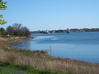
Lake Lashaway is a 293-acre (1.19 km2) pond located near the East Brookfield and North Brookfield, Massachusetts town line. The Lake Lashaway Community Association’s website is www.LakeLashaway.org. The town line cuts the lake approximately in half. The lake lies just to the north of state Route 9 as it passes through East Brookfield.
The East Brookfield River is a 2.4-mile-long (3.9 km) river in Massachusetts that heads at Lake Lashaway in East Brookfield at an elevation of 614 feet (187 m) above sea level. It continues to Quaboag Pond, at an elevation of 594 feet (181 m).
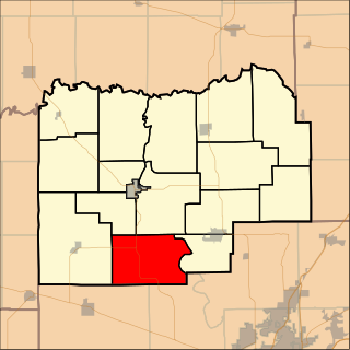
Rock Creek No. 12 Precinct is located in Menard County, Illinois. The population was 796 at the 2000 census.
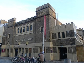
The Brighton Dome Studio Theatre is a theatre in Brighton, England. It is part of the wider Brighton Dome complex of buildings. It was built in 1935, originally as a supper room, but later converted into a theatre. Its audience capacity is 232 seated or 350 standing.
Westchester Creek is a tidal inlet of the East River located in the south eastern portion of the Bronx in New York City. It is 2.1 miles (3.39 km) in length. The creek formerly traveled further inland, to what is now Pelham Parkway, extending almost to Eastchester Bay and making Throggs Neck into an island during heavy storms. However, much of the route has been filled in, replaced by such structures as the New York City Subway's Westchester Yard and the Hutchinson Metro Center. Westchester Creek's present-day head is at Herbert H. Lehman High School; the remaining portion is largely inaccessible and surrounded by industrial enterprises or empty lots. Westchester Creek is traversed by the Bruckner Interchange at about its midpoint.

Nortonburg is an unincorporated community in Flat Rock Township, Bartholomew County, in the U.S. state of Indiana.
Cliftondale Park is an unincorporated community and census-designated place in Alleghany County, Virginia, United States. It was first listed as a CDP in the 2020 census with a population of 266.
Spanish Flat is an unincorporated community in El Dorado County, California. It is located 4 miles (6 km) north of Chili Bar, at an elevation of 2431 feet.

Solun Glacier is the 9.3 km long and 4 km wide glacier on Pernik Peninsula, Loubet Coast on the west side of Antarctic Peninsula, situated east of Škorpil Glacier and northwest of McCance Glacier. It drains the north slopes of Protector Heights, and flows northwards into Darbel Bay.
The Leqʼ a꞉ mel First Nation, formerly known as Lakahahmen First Nation, is a First Nations band government whose community and offices are located in the area near Deroche, British Columbia in the Fraser Valley region in Canada, about 12 kilometres east of the District of Mission. They are a member government of the Sto:lo Nation Chiefs Council, which is one of two tribal councils of the Sto:lo.
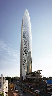
Namaste Tower is a 310 m (1,017 ft) tall skyscraper mega project in Mumbai, India. It would have been a mixed-use skyscraper with 63 floors that will house a 380-room W Hotel, office and retail space. It was designed by Atkins, Dubai. The design resembles the Namaste gesture: two wings of the hotel are clasped together like hands greeting.
Hart is an extinct village on the Santa Fe Railroad in Russell Township, Macon County, Missouri. The GNIS classifies it as a populated place. A variant name was Evelyn, the name of the local post office. A post office called Evelyn was established in 1888, and remained in operation until 1916. Besides the post office, Hart had a railroad depot.
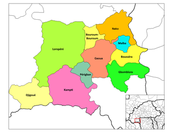
Capital: Gaoua | ||
 | ||
Coordinates: 10°03′00″N3°49′24″W / 10.05000°N 3.82333°W
| | This Poni Province location article is a stub. You can help Wikipedia by expanding it. |