Doi Ian

Last updated
Doi Ian
ดอยเอียน

Doi Lan-east of Thoeng3.JPG

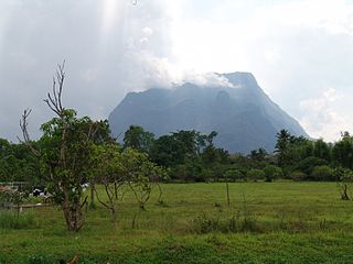
Doi Ian seen from Tap Tao, east of Thoeng
Highest point
Elevation 1,174 m (3,852 ft) [1]
Listing List of mountains in Thailand
Coordinates 19°42′12″N100°19′19″E / 19.70333°N 100.32194°E / 19.70333; 100.32194 Coordinates: 19°42′12″N100°19′19″E / 19.70333°N 100.32194°E / 19.70333; 100.32194 [2]
Geography
Parent range Phi Pan Nam Range
Climbing
First ascent unknown
Easiest route drive from Thoeng, then hike

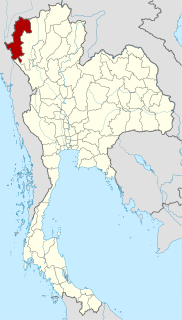
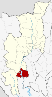
Doi Ian (Thai : ดอยเอียน) is a mountain in Thailand, part of the Phi Pan Nam Range, located at the southeastern end of Chiang Rai Province limit near the point where the limit of this province meets with the northern end of Phayao Province and only 9 km from the border with Laos. [3]

Thai language language spoken in Thailand

Thai, Central Thai or Ayutthaya or Siamese, is the sole official and national language of Thailand and the first language of the Central Thai people and vast majority of Thai of Chinese origin. It is a member of the Tai group of the Kra–Dai language family. Over half of Thai vocabulary is derived from or borrowed from Pali, Sanskrit, Mon and Old Khmer. It is a tonal and analytic language, similar to Chinese and Vietnamese.

Thailand Constitutional monarchy in Southeast Asia

Thailand, officially the Kingdom of Thailand and formerly known as Siam, is a country at the center of the Southeast Asian Indochinese peninsula composed of 76 provinces. At 513,120 km2 (198,120 sq mi) and over 68 million people, Thailand is the world's 50th largest country by total area and the 21st-most-populous country. The capital and largest city is Bangkok, a special administrative area. Thailand is bordered to the north by Myanmar and Laos, to the east by Laos and Cambodia, to the south by the Gulf of Thailand and Malaysia, and to the west by the Andaman Sea and the southern extremity of Myanmar. Its maritime boundaries include Vietnam in the Gulf of Thailand to the southeast, and Indonesia and India on the Andaman Sea to the southwest. Although nominally a constitutional monarchy and parliamentary democracy, the most recent coup in 2014 established a de facto military dictatorship.

Phi Pan Nam Range mountain range in Thailand and Laos

The Phi Pan Nam Range, also Pee Pan Nam, is a 400 km (249 mi) long system of mountain ranges in the eastern half of the Thai highlands. It is mostly in Thailand, although a small section in the northeast is within Sainyabuli and Bokeo Provinces, Laos.

Contents

Location

This mountain rises in Ngao Subdistrict, Thoeng District. Its summit is located 12 km east of Thoeng, near Ngao east of the road going from this town to Wiang Kaen town.

Ngao, Thoeng Tambon in Thailand

Ngao is a village and tambon (subdistrict) of Thoeng District, in Chiang Rai Province, Thailand. In 2005 it had a total population of 9943 people. The tambon contains 20 villages.

Thoeng District Amphoe in Chiang Rai, Thailand

Thoeng is a district (amphoe) in the eastern part of Chiang Rai Province, northern Thailand.

With a height of 1,174 metres Doi Ian is a conspicuous mountain in the surrounding landscape that can be seen from quite a distance over the plains near Thoeng town.

Climate

Doi Ian
Climate chart (explanation)
JFMAMJJASOND
 
 
29
 
 
26
16
 
 
7
 
 
29
18
 
 
46
 
 
31
21
 
 
105
 
 
32
22
 
 
205
 
 
28
22
 
 
165
 
 
26
19
 
 
385
 
 
26
22
 
 
343
 
 
24
19
 
 
259
 
 
24
20
 
 
108
 
 
24
20
 
 
96
 
 
25
18
 
 
35
 
 
24
16
Average max. and min. temperatures in °C
Precipitation totals in mm
Source: [4]

See also

Related Research Articles

Ranong Province Province in Thailand

Ranong is one of Thailand's southern provinces (changwat), on the west coast along the Andaman Sea. It has the fewest inhabitants of all Thai provinces. Neighboring Ranong are (clockwise) Chumphon, Surat Thani, and Phang Nga. To the west, it borders Kawthaung, Tanintharyi, Myanmar.

Mae Hong Son Province Province in Thailand

Mae Hong Son Province, also spelled Maehongson, Mae Hong Sorn or Maehongsorn, is one of the northern provinces (changwat) of Thailand, on the country's western border. Neighboring provinces are Shan State of Myanmar, Chiang Mai and Tak. To the west, the province borders Kayin State and Kayah State of Myanmar.

Ing River river in Thailand

The Ing River is a tributary of the Mekong River in the northern part of Thailand. It has its source in Doi Luang, Phi Pan Nam Range, in Mae Chai District, Phayao Province. The Ing flows through the plain area of Thoeng District.

Wiang Kaen District Amphoe in Chiang Rai, Thailand

Wiang Kaen is the easternmost district (amphoe) of Chiang Rai Province, northern Thailand.

Sam Ngao District District in Tak, Thailand

Sam Ngao with Tha Song Yang District is the northernmost district (amphoe) of Tak Province, western Thailand.

Ngao District Amphoe in Lampang, Thailand

Ngao is a district (amphoe) of Lampang Province, northern Thailand.

Doi Tao District District in Chiang Mai, Thailand

Doi Tao is a district (amphoe) in the southern part of Chiang Mai Province in northern Thailand.

Doi Luang National Park national park of Thailand

Doi Luang National Park is one of the biggest national parks in Northern Thailand.

Doi Chiang Dao mountain in Thailand

Doi Chiang Dao, also known as Doi Luang Chiang Dao, is a 2,175 m high mountain in Chiang Dao District of Chiang Mai Province, Thailand. It is one of the highest peaks of the Daen Lao Range on the Thai side of the border.

Doi Luang, Phi Pan Nam Range mountain in Thailand

Doi Luang is a 1,694 m high mountain in Thailand, part of the Phi Pan Nam Range.

Phu Chi Fa mountain in Chiang Rai province, Thailand

Phu Chi Fa, also Phu Chee Fah, is a mountain area and national forest park in Thailand. It is located at the northeastern end of the Phi Pan Nam Range, 12 km to the southwest of Doi Pha Tang at the eastern edge of Thoeng District, Chiang Rai Province.

Ngao, Thailand may refer to:

Doi Mae Salong mountain in Thailand

Doi Mae Salong is a mountain in Thailand, part of the Daen Lao Range. It is in the northern part of Chiang Rai Province six km from the border with Burma.

Phu Thap Boek mountain in Thailand

Phu Thap Boek is a 1,768 m high mountain in Phetchabun Province, Thailand near the border with Loei Province. It is in the Lom Kao District.

Wān Mae Aw Village in Shan State, Burma

Wān Mae Aw, is a village in Langkho Township, Langkho District, southern Shan State.

References

  1. Google Earth
  2. Google Earth
  3. "Doi Ian". Mapcarta. Retrieved 21 October 2017.
  4. "NASA Earth Observations Data Set Index". NASA. Retrieved 30 January 2016.