Dokuy Department

Last updated
Dokuy
Department
Kossi departments.png
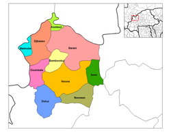
Dokuy Department location in the province
Country Flag of Burkina Faso.svg  Burkina Faso
Province Kossi Province
Population (1996)
  Total 25,305
Time zone GMT 0 (UTC+0)

Dokuy or Dokui is a department or commune of Kossi Province in western Burkina Faso. Its capital lies at the town of Dokuy. According to the 1996 census the department has a total population of 25,305. [1]

Departments of Burkina Faso administrative division and commune of Burkina Faso

The provinces of Burkina Faso are divided into 351 departments, whose urbanized areas are grouped into the same commune (municipality) with the same name as the department. The 351 communes created in those departments have three kinds of status :

Kossi Province Province in Boucle du Mouhoun, Burkina Faso

The Province de la Kossi lies in the western part of Burkina Faso and stretches to the border with Mali. It is in the Boucle du Mouhoun Region. The capital of Kossi is the town of Nouna, which has a mayor and high commissioner. The next largest town in Kossi is Djibasso, the last major town on the road from Nouna that heads west into Mali.

Burkina Faso country in Africa

Burkina Faso is a landlocked country in West Africa. It covers an area of around 274,200 square kilometres (105,900 sq mi) and is surrounded by six countries: Mali to the north; Niger to the east; Benin to the southeast; Togo and Ghana to the south; and Ivory Coast to the southwest. The July 2018 population estimate by the United Nations was 19,751,651. Burkina Faso is a francophone country, with French as the official language of government and business. Roughly 40% of the population speaks the Mossi language. Formerly called the Republic of Upper Volta (1958–1984), the country was renamed "Burkina Faso" on 4 August 1984 by then-President Thomas Sankara. Its citizens are known as Burkinabé. Its capital is Ouagadougou.

Towns and villages

Kolonkoura is a village in the Tiankoura Department of Bougouriba Province in south-western Burkina Faso. The village has a population of 215.

Related Research Articles

Mandoul Region Region in Chad

Mandoul is one of the 23 regions of Chad. Located in the south of the country, it comprises part of the former prefecture of Moyen-Chari. The regional capital is Koumra.

The Rural Municipality of Richot is a rural municipality bordering the south side of Winnipeg in Manitoba, Canada. It is part of the Winnipeg Capital Region and it had a population of 6,679 as of the 2016 census. The separately administered town of Niverville lies adjacent to its southeastern part, between it and the Rural Municipality of Hanover. The Rural Municipalty of Macdonald is to the west, and the Rural Municipality of Taché to the east. The municipality seat is located in St. Adolphe.

The Williams Lake Indian Band is a First Nations government of the Secwepemc (Shuswap) Nation, located in the Cariboo region of the Central Interior region of the Canadian province of British Columbia, at the city of Williams Lake. It was created when the government of the then-Colony of British Columbia established an Indian Reserve system in the 1860s. It is a member government of the Northern Shuswap Tribal Council. Its main Indian Reserve is Williams Lake Indian Reserve No. 1, a.k.a. "Sugarcane" or "The Cane" or "SCB".

The Kluskus First Nation is the band government of the Lhoosk’uz, a Dakelh people whose main reserve located on the Chilcotin Plateau 130 km west of the city of Quesnel, British Columbia, Canada. The First Nation is a member of the Carrier-Chilcotin Tribal Council, which includes both Tsilhqot'in and Carrier (Dakelh) communities.

Vélingara Department Department in Kolda Region, Senegal

Vélingara Department is one of the 45 departments of Senegal, one of the three making up the Kolda Region.

Kaffrine Department Department in Kaffrine Region, Senegal

Kaffrine Department is one of the 45 departments of Senegal, and is located in the Kaffrine Region, formerly part of the Kaolack Region.

Balavé Department Department in Banwa Province, Burkina Faso

Balavé is a department or commune of Banwa Province in western Burkina Faso. Its capital lies at the town of Balavé. According to the 1996 census the department has a total population of 14,820.

Zoaga is a department or commune of Boulgou Province in eastern Burkina Faso. Its capital lies at the town of Zoaga. According to the 1996 census the department has a total population of 11,295.

Soubakaniédougou Department Department in Comoé Province, Burkina Faso

Soubakaniédougou is a department or commune of Comoé Province in south-western Burkina Faso. Its capital lies at the town of Soubakaniédougou. According to the 1996 census the department has a total population of 24,136.

Djibasso Department Department in Kossi Province, Burkina Faso

Djibasso is a department or commune of Kossi Province in western Burkina Faso. Its capital lies at the town of Djibasso. According to the 1996 census the department has a total population of 46,674.

Douna Department Department in Léraba Province, Burkina Faso

Douna is a department or commune of Léraba Province in south-western Burkina Faso. Its capital lies at the town of Douna. According to the 1996 census the department has a total population of 9,132.

Gossina Department Department in Nayala Province, Burkina Faso

Gossina is a department or commune of Nayala Province in western Burkina Faso. Its capital lies at the town of Gossina. According to the 1996 census the department has a total population of 17,945.

Salogo Department Department in Plateau-Central Region, Burkina Faso

Salogo is a department or commune of Ganzourgou Province in central-eastern Burkina Faso. Its capital lies at the town of Salogo. According to the 2006 census, the department has a total population of 21,405.

HMS <i>Blackwood</i> (K313) Captain-class frigate of the Evarts-class of destroyer escort

HMS Blackwood was a Captain-class frigate of the Evarts-class of destroyer escort, originally commissioned to be built for the U.S. Navy. Before she was finished in 1942, she was transferred to the Royal Navy under the terms of Lend-Lease, and saw service during the Second World War.

Desaguadero Municipality

Desaguadero Municipality is the fourth municipal section of Ingavi Province in La Paz Department, Bolivia. Its capital is Desaguadero.

The Taku River Tlingit First Nation are the band government of the Inland Tlinkit in far northern British Columbia, Canada and also in Yukon. They comprise two ḵwaan (tribes) of the Tlingit people, who are otherwise coastal, the Áa Tlein Ḵwáan of the Atlin Lake area and the Deisleen Ḵwáan of Teslin Lake, whose main focus is the Teslin Tlingit Council in Teslin, Yukon. Their band offices are in Atlin, British Columbia.

Twifo Praso Town & District Capital

Twifu Praso is a small town and is the district capital of Twifo/Heman/Lower Denkyira District of the Central Region.

Pueblo Viejo Canton Canton in Los Ríos Province, Ecuador

Pueblo Viejo Canton is a canton of Ecuador, located in the Los Ríos Province. Its capital is the town of Pueblo Viejo. Its population at the 2001 census was 29,420.

The Leq' a: mel First Nation, formerly known as the Lakahahmen First Nation, is a First Nations band government whose community and offices are located in the area near Deroche, British Columbia, Canada, about 12 kilometres east of the District of Mission. They are a member government of the Sto:lo Nation tribal council, which is one of two tribal councils of the Sto:lo.

Mamponteng is a small town and is the capital of Kwabre, a district in the Ashanti Region of Ghana.

References

Coordinates: 12°33′00″N4°07′00″W / 12.55000°N 4.11667°W / 12.55000; -4.11667

Geographic coordinate system Coordinate system

A geographic coordinate system is a coordinate system that enables every location on Earth to be specified by a set of numbers, letters or symbols. The coordinates are often chosen such that one of the numbers represents a vertical position and two or three of the numbers represent a horizontal position; alternatively, a geographic position may be expressed in a combined three-dimensional Cartesian vector. A common choice of coordinates is latitude, longitude and elevation. To specify a location on a plane requires a map projection.