Djibasso Department

Last updated
Djibasso
Department
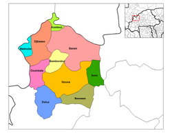
Kossi departments.png
Djibasso Department location in the province
Country Flag of Burkina Faso.svg  Burkina Faso
Province Kossi Province
Population
 (1996)
  Total46,674
Time zone UTC+0 (GMT 0)

Djibasso is a department or commune of Kossi Province in western Burkina Faso. Its capital lies at the town of Djibasso. According to the 1996 census the department has a total population of 46,674. [1]

Towns and villages

Populated PlacePopulationSub-Prefecture
Djibasso 5 326 Djibasso Subprefecture
Ba 2 084 Djibasso Subprefecture
Banana 373 Djibasso Subprefecture
Bankoumana 489 Djibasso Subprefecture
Bara 565 Bara Subprefecture
Berkoué 746 Bara Subprefecture
Bida 718 Bara Subprefecture
Bokoro 163 Bara Subprefecture
Bonoua 400 Bara Subprefecture
Bouakuy 857 Bara Subprefecture
Diékan 404 Diékan Subprefecture
Diekuini 413 Bara Subprefecture
Diena 1 634 Bara Subprefecture
Donkoro 197 Diékan Subprefecture
Foni-Boronkin 688 Diékan Subprefecture
Gnimini 852 Diékan Subprefecture
Ira 3 038 Diékan Subprefecture
Kansara 561 Diékan Subprefecture
Kienekuy 1 248 Diékan Subprefecture
Kira 987 Djibasso Subprefecture
Kolonkan 611 Kolonzo Subprefecture
Kolonkani-Sirakoro 562 Kolonzo Subprefecture
Kolonzo 622 Kolonzo Subprefecture
Kombori 1 519 Kombori Subprefecture
Maoulena 837 Kolonzo Subprefecture
Mandara 777 Kolonzo Subprefecture
Massakuy 250 Kolonzo Subprefecture
Mouna 90 Kolonzo Subprefecture
Nairena 1 067 Kolonzo Subprefecture
Ouarokuy 1 026 Kolonzo Subprefecture
Oura2 482 Kolonzo Subprefecture
Parakuy 253 Parakuy Subprefecture
Paranzo 433 Parakuy Subprefecture
Pia n° 1 2 552 Parakuy Subprefecture
Saba 1 737 Parakuy Subprefecture
Sadignakono 365 Parakuy Subprefecture
Sakuy 328 Parakuy Subprefecture
Samekuy 941 Parakuy Subprefecture
Sarakoro 1 252 Parakuy Subprefecture
Senoulo 35 Parakuy Subprefecture
Siedougou 196 Parakuy Subprefecture
Soumoukuy 284 Parakuy Subprefecture
Sounè 684 Parakuy Subprefecture
Soye 2 346 Parakuy Subprefecture
Tiemè 2 984 Parakuy Subprefecture
Voro698 Kolonzo Subprefecture

Related Research Articles

Princess Royal Island

Princess Royal Island is the largest island on the North Coast of British Columbia, Canada. It is located amongst the isolated inlets and islands east of Hecate Strait on the British Columbia Coast. At 2,251 square kilometres (869 sq mi), it is the fourth largest island in British Columbia. Princess Royal Island was named in 1788 by Captain Charles Duncan, after his sloop Princess Royal.

Eskers Provincial Park

Eskers Provincial Park is a provincial park in British Columbia, Canada. The park comprises roughly 4,044 hectares and was created in 1987. Located west of Nukko Lake, which lies northwest of the city of Prince George, it protects an area of the 40-kilometre (25 mi) Stuart River Eskers Complex. Eskers are winding ridges of gravel formed by the glaciers which once covered the British Columbia Interior.

Shuswap Lake Marine Provincial Park is an 896-hectare provincial park in British Columbia, Canada, comprising 991 ha. The Park has a variety of amenities including boat launch ramps, picnic areas, and 27 campsites around the perimeter of Shuswap Lake. The lake's name and that of the surrounding Shuswap Country is from the Shuswap people (Secwepemc), the most northern of the Salishan speaking people.

Saskatchewan Highway 316 Highway in Saskatchewan

Highway 316 is a highway in the Canadian province of Saskatchewan. It runs from Highway 16 near Clavet to Highway 5. Highway 316 is about 17 km (11 mi.) long. This area is an industrial commercial area along Highway #316 which extends from Clavet north to the PCS Patience Lake Mine which is just 10 miles from the city of Saskatoon. Highway 316 is a primary weight highway, and also runs near the Canadian National Railway line which goes from Saskatoon through Clavet. In 1941, the Canadian Pacific Railway ran from Saskatoon through Cheviot and on south eastward.

Gwaʼsala-ʼNakwaxdaʼxw Nations

The Gwa'Sala-Nakwaxda'xw Nations are a union of two Kwakwaka'wakw peoples in a band government based on northern Vancouver Island in British Columbia, Canada, whose main reserve community is near the town of Port Hardy in the Queen Charlotte Strait region of the Central Coast region of British Columbia, Canada. The band government is a member of the Kwakiutl District Council and, for treaty negotiation purposes, the Winalagalis Treaty Group which includes three other members of the Kwakiutl District Council.

The Williams Lake First Nation is a First Nations government of the Secwepemc (Shuswap) Nation, located in the Cariboo region of the Central Interior region of the Canadian province of British Columbia, at the city of Williams Lake. It was created when the government of the then-Colony of British Columbia established an Indian Reserve system in the 1860s. It is a member government of the Northern Shuswap Tribal Council. Its main Indian Reserve is Williams Lake Indian Reserve No. 1, a.k.a. "Sugarcane" or "The Cane" or "SCB".

The Esk'etemc First Nation, also known as the Alkali Lake Indian Band, is a First Nations government of the Secwepemc (Shuswap) people, located at Alkali Lake in the Cariboo region of the Central Interior of the Canadian province of British Columbia. It was created when the government of the then-Colony of British Columbia established an Indian Reserve system in the 1860s. It is one of three Secwepemc bands that is not a member of either the Shuswap Nation Tribal Council or the Northern Shuswap Tribal Council.

The Kluskus First Nation is the band government of the Lhoosk’uz, a Dakelh people whose main reserve located on the Chilcotin Plateau 130 km west of the city of Quesnel, British Columbia, Canada. The First Nation is a member of the Carrier-Chilcotin Tribal Council, which includes both Tsilhqot'in and Carrier (Dakelh) communities.

The Tŝideldel First Nation is the band government of the Tsi Del Del subgroup of the Tsilhqot'in people, located in the Chilcotin District in the western Central Interior region of the Canadian province of British Columbia. It is a member of the Tsilhqot'in National Government.

The Tl'etinqox-t'in Government Office is a First Nations government located in the Chilcotin District in the western Central Interior region of the Canadian province of British Columbia. Governing a reserve communities near Alexis Creek known as Anaham Reserve First Nations or Anaham, it is a member of the Tsilhqot'in Tribal Council aka known as the Tsilhqot'in National Government. The main reserve is officially known as Anahim's Flat No. 1, and is more commonly as Anaham. Other reserves are Anahim's Meadow No. 2 and 2A, and Anahim Indian Reserves Nos. 3 through 18. Anaham, or Anahim and Alexis were chiefs of the Tsilhqot'in during the Chilcotin War of 1864, although they and their people did not take part in the hostilities.

Sabuwa LGA and town in Katsina State, Nigeria

Sabuwa is a Local Government Area in Katsina State, Nigeria. Its headquarters are in the town of Sabuwa in the south of the area near sabuwa new market, on the border with Kaduna State at11°10′00″N7°07′00″E.

Vélingara Department Department in Kolda Region, Senegal

Vélingara Department is one of the 45 departments of Senegal, one of the three making up the Kolda Region.

Kaffrine Department Department in Kaffrine Region, Senegal

Kaffrine Department is one of the 45 departments of Senegal, and is located in the Kaffrine Region, formerly part of the Kaolack Region.

Barani Department Department in Kossi Province, Burkina Faso

Barani is a department or commune of Kossi Province in western Burkina Faso. Its capital lies at the town of Barani. According to the 1996 census the department has a total population of 49,144.

Nicomen Island is an island in the Fraser River east of Mission and between Deroche (E) and Dewdney (W). Located on the river's north side, and separated from the foot of the Douglas Ranges by Nicomen Slough, the island is near-totally given over to agriculture and constitutes a rural community in its own right, although "downtown Dewdney" is located near its western end and the Indian Reserve of the Lakahahmen First Nation is located about mid-way along its north side.

Mount Lookout, West Virginia Unincorporated community in West Virginia, United States

Mt. Lookout is a small unincorporated community in Nicholas County, West Virginia, United States, 10 miles (16 km) south of Summersville.

The Tahltan First Nation, also known as the Tahltan Indian Band, is a band government of the Tahltan people. Their main community and reserves are located at Telegraph Creek, British Columbia. Their language is the Tahltan language, which is an Athabaskan language also known as Nahanni, is closely related to Kaska and Dunneza. Their Indian and Northern Affairs Canada band number is 682. The Tahltan First Nation is joined with the Iskut First Nation in a combined tribal council-type organization known as the Tahltan Nation.

The Hartley Bay Indian Band, also known as the Hartley Bay First Nation, Hartley Bay Band, Gitga'at Nation and Gitga'at First Nation, is the band government of the Gitga'ata people of Hartley Bay, British Columbia, Canada.

The Klesilkwa River is a tributary of the Skagit River, flowing east to join that river to the west of Shawatum Mountain after arising near Klesilkwa Mountain, on the east flank of Chilliwack Lake.

The Leqʼ a꞉ mel First Nation, formerly known as the Lakahahmen First Nation, is a First Nations band government whose community and offices are located in the area near Deroche, British Columbia, Canada, about 12 kilometres east of the District of Mission. They are a member government of the Sto:lo Nation Chiefs Council, which is one of two tribal councils of the Sto:lo.

References

Coordinates: 13°07′00″N4°10′00″W / 13.11667°N 4.16667°W / 13.11667; -4.16667