Kombori Department

Last updated
Kombori
Department
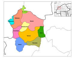
Kossi departments.png
Kombori Department location in the province
Country Flag of Burkina Faso.svg  Burkina Faso
Province Kossi Province
Population (1996)
  Total 9,610
Time zone GMT 0 (UTC+0)

Kombori is a department or commune of Kossi Province in western Burkina Faso. Its capital lies at the town of Kombori. According to the 1996 census the department has a total population of 9,610. [1]
Departments of Burkina Faso administrative division and commune of Burkina Faso

The provinces of Burkina Faso are divided into 351 departments, whose urbanized areas are grouped into the same commune (municipality) with the same name as the department. The 351 communes created in those departments have three kinds of status :

Kossi Province Province in Boucle du Mouhoun, Burkina Faso

The Province de la Kossi lies in the western part of Burkina Faso and stretches to the border with Mali. It is in the Boucle du Mouhoun Region. The capital of Kossi is the town of Nouna, which has a mayor and high commissioner. The next largest town in Kossi is Djibasso, the last major town on the road from Nouna that heads west into Mali.

Burkina Faso country in Africa

Burkina Faso is a landlocked country in West Africa. It covers an area of around 274,200 square kilometres (105,900 sq mi) and is surrounded by six countries: Mali to the north; Niger to the east; Benin to the southeast; Togo and Ghana to the south; and Ivory Coast to the southwest. The July 2018 population estimate by the United Nations was 19,751,651. Burkina Faso is a francophone country, with French as the official language of government and business. Roughly 40% of the population speaks the Mossi language. Formerly called the Republic of Upper Volta (1958–1984), the country was renamed "Burkina Faso" on 4 August 1984 by then-President Thomas Sankara. Its citizens are known as Burkinabé. Its capital is Ouagadougou.

Towns and villages

Siekoro is a village in the Ouo Department of Comoé Province in south-western Burkina Faso. The village has a population of 650.

Related Research Articles

Tipacoque Municipality and town in Boyacá Department, Colombia

Tipacoque is a municipality and town in Boyacá Department, Colombia, located on the Altiplano Cundiboyacense, part of the Eastern Ranges of the Colombian Andes. Tipacoque is situated on the western flank of the Chicamocha river canyon. It is part of the Northern Boyacá Province.

Pajarito, Boyacá Municipality and town in Boyacá Department, Colombia

Pajarito is a town and municipality in the La Libertad Province, part of the Colombian department of Boyacá. The municipality, situated in the southeast of the department borders Labranzagrande and Aquitania of the department of Boyacá and Yopal, Recetor and Aguazul of the department of Casanare. The urban centre is located at a distance of 147 kilometres (91 mi) from the department capital Tunja at an altitude of 800 metres (2,600 ft) in a tight valley, not allowing much expansion of the urban area. The centre is experiencing periodic landslides.

Jambaló Municipality and town in Cauca Department, Colombia

Jambaló is a municipality and, at the same time, an indigenous reservation of Colombia. It is located in the northeastern department of Cauca, 80 kilometers north of the city of Popayán. It borders on the north with the municipalities of Caloto and Toribío, on the east with the municipality of Páez, on the south with the municipality of Silvia and on the west with the municipalities of Caldono and Santander de Quilichao. The municipal head is the most populous urban center of the territory and is also called "Jambaló", is located in the extreme south, on the limits with the municipality of Silvia; However, in the rural area it is where the majority of the population lives (94%). Being Jambaló also indigenous guard, the majority of its inhabitants are of the nasa and misak ethnic groups.

Sasamón Municipality and town in Castile and León, Spain

Sasamón is a municipality and town located in the province of Burgos, Castile and León, Spain. According to the 2004 census (INE), the municipality has a population of 1,346 inhabitants.

Sisante is a municipality located in the Cuenca Province, Castile-La Mancha, Spain. According to the 2004 census (INE), the municipality has a population of 1,795 inhabitants.

Castro de Fuentidueña is a municipality located in the province of Segovia, Castile and León, Spain. According to the 2004 census (INE), the municipality has a population of 73 inhabitants.

Buitrago Place in Castilla y Leon, Spain

Buitrago is a municipality located in the province of Soria, Soria, Spain. According to the 2004 census (INE), the municipality had a population of 55 inhabitants.

Ba Bể is a rural district of Bắc Kạn Province in the northeast region of Vietnam. As of 2003 the district had a population of 47,910. The district covers an area of 678 km². The district capital lies at Chợ Rã.

Siby Department Department in Balé, Burkina Faso

Siby is a department or commune of Balé Province in southern Burkina Faso. Its capital lies at the town of Siby. According to the 1996 census the department has a total population of 12,089.

Kouka Department Department in Banwa Province, Burkina Faso

Kouka is a department or commune of Banwa Province in western Burkina Faso. Its capital lies at the town of Kouka. According to the 1996 census the department has a total population of 53,415.

Ouo Department Department in Comoé Province, Burkina Faso

Ouo is a department or commune of Comoé Province in southern Burkina Faso. Its capital lies at the town of Ouo. According to the 1996 census the department has a total population of 15,594.

Méguet Department Department in Ganzourgou Province, Burkina Faso

Méguet is a department or commune of Ganzourgou Province in central-eastern Burkina Faso. Its capital lies at the town of Méguet. According to the 1996 census the department has a total population of 34,668.

Barani Department Department in Kossi Province, Burkina Faso

Barani is a department or commune of Kossi Province in western Burkina Faso. Its capital lies at the town of Barani. According to the 1996 census the department has a total population of 49,144.

Djibasso Department Department in Kossi Province, Burkina Faso

Djibasso is a department or commune of Kossi Province in western Burkina Faso. Its capital lies at the town of Djibasso. According to the 1996 census the department has a total population of 46,674.

Madouba Department Department in Kossi Province, Burkina Faso

Madouba is a department or commune of Kossi Province in western Burkina Faso. Its capital lies at the town of Madouba. According to the 1996 census the department has a total population of 5,949.

Yargo Department Department in Kouritenga Province, Burkina Faso

Yargo is a department or commune of Kouritenga Province in eastern Burkina Faso. Its capital lies at the town of Yargo. According to the 1996 census the department has a total population of 14,473.

Ouéléni Department Department in Léraba Province, Burkina Faso

Ouéleni is a department or commune of Léraba Province in south-western Burkina Faso. Its capital lies at the town of Ouéleni. According to the 1996 census the department has a total population of 10.020.

Koumbri Department Department in Yatenga Province, Burkina Faso

Koumbri is a department or commune of Yatenga Province in northern Burkina Faso. Its capital lies at the town of Koumbri.

Léo Department Department in Sissili Province, Burkina Faso

Leo is a department or commune of Sissili Province in southern Burkina Faso. Its capital lies at the town of Leo.

São Joaquim do Monte

São Joaquim do Monte is a city located in the state of Pernambuco, Brazil. Located at 124.6 km away from Recife, capital of the state of Pernambuco. Has an estimated population of 21.872 inhabitants.

References

Coordinates: 13°51′N2°25′W / 13.850°N 2.417°W / 13.850; -2.417

Geographic coordinate system Coordinate system

A geographic coordinate system is a coordinate system that enables every location on Earth to be specified by a set of numbers, letters or symbols. The coordinates are often chosen such that one of the numbers represents a vertical position and two or three of the numbers represent a horizontal position; alternatively, a geographic position may be expressed in a combined three-dimensional Cartesian vector. A common choice of coordinates is latitude, longitude and elevation. To specify a location on a plane requires a map projection.