Sono | |
---|---|
Department | |
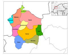
![]() Sono Department location in the province | |
Country | ![]() |
Province | Kossi Province |
Population (2006) | |
• Total | 7,276 |
Time zone | GMT 0 (UTC+0) |
Sono is a department of Kossi Province in western Burkina Faso. It is in the Boucle du Mouhoun Region. The capital of the department is Sono. The population of the department in 2006 was 7,276. [1]
The provinces of Burkina Faso are divided into 351 departments, whose urbanized areas are grouped into the same commune (municipality) with the same name as the department. The 351 communes created in those departments have three kinds of status :
The Province de la Kossi lies in the western part of Burkina Faso and stretches to the border with Mali. It is in the Boucle du Mouhoun Region. The capital of Kossi is the town of Nouna, which has a mayor and high commissioner. The next largest town in Kossi is Djibasso, the last major town on the road from Nouna that heads west into Mali.
Boucle du Mouhoun is one of Burkina Faso's 13 administrative regions. It was created on 2 July 2001 and had a population of 1,434,847 in 2006. It is the 2nd most populous region in Burkina Faso after Centre Region, and contains 10.5% of all Burkinabé. The region's capital is Dédougou. Six provinces make up the Boucle du Mouhoun region—Balé, Banwa, Kossi, Mouhoun, Nayala, and Sourou.
Dosquebradas is the second largest city and a municipality in the Risaralda Department, Colombia. As of 2005, it had a population of approximately 200,000 inhabitants. The city is connected by the César Gaviria Trujillo Viaduct to Pereira, the capital of the department.
Alonso de Ibáñez is a province in the northern parts of the Bolivian Potosí Department. Its capital is Sacaca.
Charcas is a province in the northern parts of the Bolivian Potosí Department. Its capital is San Pedro de Buena Vista.
Miranda de Arga is a town and municipality located in the province and autonomous community of Navarre, northern Spain.
Punata is the capital of Punata Province and Punata Municipality in Cochabamba Department, Bolivia. At the time of census 2012 it had a population of 19,559 inhabitants and at the census 2012 the populations rose to 28.707 inhabitants. People from Punata and surrounding areas used to be called “Vallunos” meaning coming from the valleys of Punata and other surrounding small towns. Punata is renowned for its wonderful agricultural market held every Tuesday where people from surrounding towns and rural villages come to sell and buy.
Harbour Breton is a small fishing community on the Connaigre Peninsula in Fortune Bay, on the south coast of the island of Newfoundland in Canada. It is the largest center on the Connaigre Peninsula and was long considered the unofficial capital of Fortune Bay. Many residents resettled from Sagona Island, Jersey Harbour, Little Bay West, Miller's Passage, Red Cove, and Grole.
Laki is a small town in Laki Municipality in Plovdiv Province, southern Bulgaria. As of 2006 it has 2,615 inhabitants. It is located in the Rhodope mountains at 54 km to the south of the province capital Plovdiv and at 88 to the north of Smolyan. There is a lead-zinc flotation factory, several textile plants and timber workshops.
Lentegí is a municipality located in the province of Granada, Spain. According to the 2006 census (INE), the city has a population of 342 inhabitants.
Dosbarrios is a municipality located in the province of Toledo, Castile-La Mancha, Spain. According to the 2006 census (INE), the municipality has a population of 2280 inhabitants.
Carrias is a municipality located in the province of Burgos, Castile and León, Spain. According to the 2013 census (INE), the municipality has a population of 26 inhabitants.
Bana is a department or commune of Balé Province in southern Burkina Faso. Its capital lies at the town of Bana. According to the 1996 census the department has a population of 12,299.
Kouka is a department or commune of Banwa Province in western Burkina Faso. Its capital lies at the town of Kouka. According to the 1996 census the department has a total population of 53,415.
Sanaba is a department or commune of Banwa Province in western Burkina Faso. Its capital lies at the town of Sanaba. According to the 1996 census the department has a total population of 29,525.
Tansila is a department or commune of Banwa Province in western Burkina Faso. Its capital lies at the town of Tansila. According to the 1996 census the department has a total population of 27,714.
Ouo is a department or commune of Comoé Province in southern Burkina Faso. Its capital lies at the town of Ouo. According to the 1996 census the department has a total population of 15,594.
Mogtédo is a department or commune of Ganzourgou Province in central-eastern Burkina Faso. Its capital lies at the town of Mogtédo. According to the 2006 general population census, actualized in 2012 for the municipal elections, the department has a total population of 44,668.
Zam is a department or commune of Ganzourgou Province in central-eastern Burkina Faso. Its capital lies at the town of Zam. According to the 1996 census the department has a total population of 39,259.
Dakoro is a department or commune of Léraba Province in south-western Burkina Faso. Its capital lies at the town of Dakoro. According to the 1996 census the department has a total population of 12,864.
Ouarkoye is a department or commune of Mouhoun Province in western Burkina Faso. Its capital lies at the town of Ouarkoye. According to the 1996 census the department has a total population of 37,178.
Salogo is a department or commune of Ganzourgou Province in central-eastern Burkina Faso. Its capital lies at the town of Salogo. According to the 2006 census, the department has a total population of 21,405.
Coordinates: 12°50′N3°29′W / 12.833°N 3.483°W
A geographic coordinate system is a coordinate system that enables every location on Earth to be specified by a set of numbers, letters or symbols. The coordinates are often chosen such that one of the numbers represents a vertical position and two or three of the numbers represent a horizontal position; alternatively, a geographic position may be expressed in a combined three-dimensional Cartesian vector. A common choice of coordinates is latitude, longitude and elevation. To specify a location on a plane requires a map projection.
![]() | This Kossi Province location article is a stub. You can help Wikipedia by expanding it. |