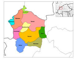
Doumbala Department

Last updated
Doumbala
Department
Kossi departments.png
Doumbala Department location in the province
Country Flag of Burkina Faso.svg  Burkina Faso
Province Kossi Province
Population (1996)
  Total 26,124
Time zone GMT 0 (UTC+0)

Doumbala is a department or commune of Kossi Province in western Burkina Faso. Its capital lies at the town of Doumbala. According to the 1996 census the department has a total population of 26,124. [1]

Departments of Burkina Faso administrative division and commune of Burkina Faso

The provinces of Burkina Faso are divided into 351 departments, whose urbanized areas are grouped into the same commune (municipality) with the same name as the department. The 351 communes created in those departments have three kinds of status :

Kossi Province Province in Boucle du Mouhoun, Burkina Faso

The Province de la Kossi lies in the western part of Burkina Faso and stretches to the border with Mali. It is in the Boucle du Mouhoun Region. The capital of Kossi is the town of Nouna, which has a mayor and high commissioner. The next largest town in Kossi is Djibasso, the last major town on the road from Nouna that heads west into Mali.

Burkina Faso country in Africa

Burkina Faso is a landlocked country in West Africa. It covers an area of around 274,200 square kilometres (105,900 sq mi) and is surrounded by six countries: Mali to the north; Niger to the east; Benin to the southeast; Togo and Ghana to the south; and Ivory Coast to the southwest. The July 2018 population estimate by the United Nations was 19,751,651. Burkina Faso is a francophone country, with French as the official language of government and business. Roughly 40% of the population speaks the Mossi language. Formerly called the Republic of Upper Volta (1958–1984), the country was renamed "Burkina Faso" on 4 August 1984 by then-President Thomas Sankara. Its citizens are known as Burkinabé. Its capital is Ouagadougou.

Towns and villages

Bankuy is a commune located in the Doumbala Department of Kossi Province, Burkina Faso.

Related Research Articles

Gold Muchalat Provincial Park is a provincial park in British Columbia, Canada, located between the Gold and Muchalat Rivers.

Shuswap Lake Marine Provincial Park is an 896-hectare provincial park in British Columbia, Canada, comprising 991 ha. The Park has a variety of amenities including boat launch ramps, picnic areas, and 27 campsites around the perimeter of Shuswap Lake. The lake's name and that of the surrounding Shuswap Country is from the Shuswap people (Secwepemc), the most northern of the Salishan speaking people.

Kaimes is a suburb of Edinburgh, the capital of Scotland. It is south of Alnwickhill.

Mariana is a municipality located in the province of Cuenca, Castile-La Mancha, Spain. According to the 2006 census (INE), the municipality has a population of 334 inhabitants.

Gwaʼsala-ʼNakwaxdaʼxw Nations

The Gwa'Sala-Nakwaxda'xw Nations are a union of two Kwakwaka'wakw peoples in a band government based on northern Vancouver Island in British Columbia, Canada, whose main reserve community is near the town of Port Hardy in the Queen Charlotte Strait region of the Central Coast region of British Columbia, Canada. The band government is a member of the Kwakiutl District Council and, for treaty negotiation purposes, the Winalagalis Treaty Group which includes three other members of the Kwakiutl District Council.

French submarine <i>Rubis</i> (1931)

The French submarine Rubis was a Saphir-class minelaying submarine which first served in the French submarine pavilion, then the Free French Naval Forces (FNFL) during the Second World War and back with the French Navy. The boat was awarded numerous awards. Accordingly, as a result of Rubis's service with the FNFL, the boat was made a companion of the Ordre de la Libération by a decree issued by General Charles de Gaulle on 14 October 1941.

Chinavita Municipality and town in Boyacá Department, Colombia

Chinavita is a town and municipality in the Neira Province, part of the Colombian department of Boyacá. The urban centre of Chinavita is located at 39 kilometres (24 mi) from the department capital Tunja on the Altiplano Cundiboyacense and the municipality borders Tibaná and Ramiriquí in the north, Ramiriquí and Miraflores in the east, Garagoa in the south and in the west Pachavita and Úmbita.

The Selwyn Range is a mountain range in the Canadian Rockies in British Columbia. A subrange of the Park Ranges of the Continental Ranges, it is located west of Jasper National Park, east of Valemount and south of Mount Robson Provincial Park.

Niangoloko Place in Cascades Region, Burkina Faso

Niangoloko is a town and seat of the Niangoloko Department in southwestern Burkina Faso. It is near the city of Bobo-Dioulasso and the border with Côte d'Ivoire. The town has a population of 26,028.

Mederdra Commune and town in Trarza, Mauritania

Mederdra is a small town and commune in south-west Mauritania. In 2000 it had a population of 6,858.

Balavé Department Department in Banwa Province, Burkina Faso

Balavé is a department or commune of Banwa Province in western Burkina Faso. Its capital lies at the town of Balavé. According to the 1996 census the department has a total population of 14,820.

Bondigui is a department or commune of Bougouriba Province in south-western Burkina Faso. Its capital lies at the town of Bondigui. According to the 2006 census the department has a total population of 18,782.

Zam Department Department in Ganzourgou Province, Burkina Faso

Zam is a department or commune of Ganzourgou Province in central-eastern Burkina Faso. Its capital lies at the town of Zam. According to the 1996 census the department has a total population of 39,259.

Barani Department Department in Kossi Province, Burkina Faso

Barani is a department or commune of Kossi Province in western Burkina Faso. Its capital lies at the town of Barani. According to the 1996 census the department has a total population of 49,144.

Djibasso Department Department in Kossi Province, Burkina Faso

Djibasso is a department or commune of Kossi Province in western Burkina Faso. Its capital lies at the town of Djibasso. According to the 1996 census the department has a total population of 46,674.

Douna Department Department in Léraba Province, Burkina Faso

Douna is a department or commune of Léraba Province in south-western Burkina Faso. Its capital lies at the town of Douna. According to the 1996 census the department has a total population of 9,132.

Batié Department Department in Noumbiel Province, Burkina Faso

Batié is a department or commune of Noumbiel Province in southeastern Burkina Faso. Its capital lies at the town of Batié.

Fimbulheimen

Fimbulheimen is a mountain range in Queen Maud Land, Antarctica. It stretches from Jutulstraumen by 1° west of Carsten Borchgrevink Ice at 18° east, about 200 km from the ice edge. Fimbulheimen is thus between Maudheim Plateau and Sør-Rondane.

Gbi & Doru District is one of 17 districts of Nimba County, Liberia. As of 2008, the population was 8,131.

References

Coordinates: 12°55′00″N4°10′00″W / 12.91667°N 4.16667°W / 12.91667; -4.16667

Geographic coordinate system Coordinate system

A geographic coordinate system is a coordinate system that enables every location on Earth to be specified by a set of numbers, letters or symbols. The coordinates are often chosen such that one of the numbers represents a vertical position and two or three of the numbers represent a horizontal position; alternatively, a geographic position may be expressed in a combined three-dimensional Cartesian vector. A common choice of coordinates is latitude, longitude and elevation. To specify a location on a plane requires a map projection.