
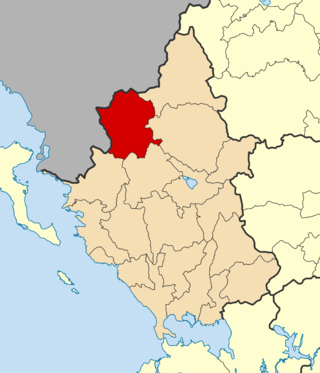
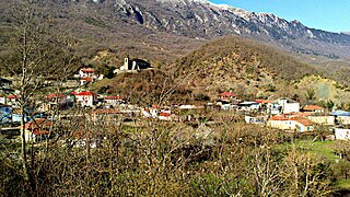
Papingo is a former community (1919-2010) in the Ioannina regional unit, Epirus, Greece. Since the 2011 local government reform it has become part of the municipality of Zagori, of which it is a municipal unit. The municipal unit has an area of 34.131 km2. It is located in the Vikos–Aoös National Park.

East Zagori is a former municipality in the Ioannina regional unit, Epirus, Greece. Since the 2011 local government reform it is part of the municipality Zagori, of which it is a municipal unit. The municipal unit has an area of 269.657 km2. Population 1,113 (2021). The seat of the municipality was in Miliotades.

Central Zagori is a former municipality in the Ioannina regional unit, Epirus, Greece. Since the 2011 local government reform, it has been part of the municipality Zagori, of which it is a municipal unit. The municipal unit has an area of 206.683 km2. Its population was 1,059 in 2021. The seat of the municipal unit is in Asprangeloi.

Aetomilitsa is a village in the Ioannina regional unit, Epirus, Greece. Since the 2011 local government reform it is part of the municipality Konitsa, of which it is a municipal unit. Before 2011, it was an independent community. The 2021 census recorded 200 residents in the village. The community of Aetomilitsa covers an area of 51.297 square kilometres (19.806 sq mi).

Vovousa is a village and a former community in the Ioannina regional unit, Epirus, Greece. Since the 2011 local government reform it is part of the municipality Zagori, of which it is a municipal unit. The municipal unit has an area of 51.029 km2. It is one of the original Zagori villages. Population 132 (2021). Vovousa is a traditional Aromanian settlement.

Distrato is a village and a former community in the Ioannina regional unit, Epirus, Greece. Since the 2011 local government reform it is part of the municipality Konitsa, of which it is a municipal unit. The municipal unit has an area of 53.837 km2. Population 207 (2021).

Kalarrytes is a village and a former community in the Ioannina regional unit, Epirus, Greece. It is populated mostly by Aromanians (Vlachs). Since the 2011 local government reform it is part of the municipality North Tzoumerka, of which it is a municipal unit. The municipal unit has an area of 39.959 km2. The population in 2021 was 236.

Matsouki is an Aromanian village and a former community in the Ioannina regional unit, Epirus, Greece. Since the 2011 local government reform it is part of the municipality North Tzoumerka, of which it is a municipal unit. The municipal unit has an area of 35.360 km2. Population 274 (2021).

Milea is an Aromanian village and a former community in the Ioannina regional unit, Epirus, Greece. Since the 2011 local government reform it is part of the municipality Metsovo, of which it is a municipal unit. The 2021 census recorded 311 residents in Milea. The community of Milea covers an area of 54.556 km2. Milea is 15 km away from Metsovo.

Fourka is a village and a former community in the Ioannina regional unit, Epirus, Greece. Since the 2011 local government reform it is part of the municipality Konitsa, of which it is a municipal unit. The municipal unit has an area of 32.374 km2. Population 56 (2021).
Pogoni is a municipality in the Ioannina regional unit, Epirus, Greece. The seat of the municipality is the village Kalpaki. The municipality has an area of 701.059 km2. Its population was 6,848 at the 2021 census.
Kavallari is a village and a community of the Zagori municipality. Before the 2011 local government reform it was part of the municipality of East Zagori, of which it was a municipal district. The 2021 census recorded 57 inhabitants in the village. The community of Kavallari covers an area of 21.031 km2.

Anilio is an Aromanian village and a community of the Metsovo municipality. Since the 2011 local government reform it is part of the municipality Metsovo, of which it is a municipal district. The 2021 census recorded 548 residents in Anilio. The community of Anilio covers an area of 42.637 km2.
Kastanonas is an Aromanian village and a community of the Zagori municipality. Before the 2011 local government reform it was part of the municipality of East Zagori, of which it was a municipal district. The 2021 census recorded 15 inhabitants in the village. The community of Kastanonas covers an area of 9.551 km2.
Greveniti is a village and a community of the Zagori municipality in Ioannina Regional Unit, Greece. Before the 2011 local government reform it was part of the municipality of East Zagori, of which it was a municipal district. The 2021 census recorded 109 inhabitants in the village. The community of Greveniti covers an area of 37.077 km2. Greveniti is a traditional Aromanian (Vlach) settlement.
Tristeno, is a village and a community of the Zagori municipality. Before the 2011 local government reform it was part of the municipality of East Zagori, of which it was a municipal district. The 2021 census recorded 55 inhabitants in the village. The community of Tristeno covers an area of 15.325 km2.
Flambourari is a Greek village and a community of the Zagori municipality. Before the 2011 local government reform it was part of the municipality of East Zagori, of which it was a municipal district. The 2021 census recorded 63 inhabitants in the village. The community of Flambourari covers an area of 39.403 km2. Flambourari is a traditional Aromanian-speaking settlement.
Makrino is a village and a community of the Zagori municipality. Before the 2011 local government reform it was part of the municipality of East Zagori, of which it was a municipal district. The 2021 census recorded 30 inhabitants in the village. The community of Makrino covers an area of 20.147 km2. Makrino is a traditional Aromanian-speaking settlement.
Elatochori is a village and a community of the Zagori municipality, northwestern Greece. Before the 2011 local government reform it was part of the municipality of East Zagori, of which it was a municipal district. The 2021 census recorded 85 inhabitants in the community. The community of Elatochori covers an area of 34.802 km2.
Dilakko is a village of the Zagori municipality, northwestern Greece. Before the 2011 local government reform it was part of the municipality of East Zagori. The 2021 census recorded 12 inhabitants in the village. The village of Dilakko is a part of the community of Elatochori.

