Dolna Krushitsa

Last updated
Dolna Krushitsa
Village
Country Flag of Bulgaria.svg  Bulgaria
Province Blagoevgrad Province
Municipality Petrich Municipality
Time zone EET (UTC+2)
  Summer (DST) EEST (UTC+3)

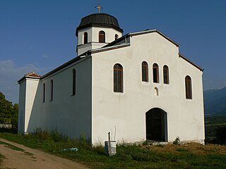
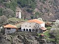
Dolna Krushitsa is a village in Petrich Municipality, in Blagoevgrad Province, Bulgaria. [1]

Petrich Municipality Municipality in Blagoevgrad, Bulgaria

Petrich Municipality is a municipality in Blagoevgrad Province in Southwestern Bulgaria.

Blagoevgrad Province Province in Bulgaria

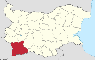
Blagoevgrad Province, also known as Pirin Macedonia is a province (oblast) of southwestern Bulgaria. It borders four other Bulgarian provinces to the north and east, to the Greek region of Macedonia to the south, and North Macedonia to the west. The province has 14 municipalities with 12 towns. Its principal city is Blagoevgrad, while other significant towns include Bansko, Gotse Delchev, Melnik, Petrich, Razlog, Sandanski, and Simitli.

Bulgaria country in Southeast Europe

Bulgaria, officially the Republic of Bulgaria, is a country in Southeast Europe. It is bordered by Romania to the north, Serbia and North Macedonia to the west, Greece and Turkey to the south, and the Black Sea to the east. The capital and largest city is Sofia; other major cities are Plovdiv, Varna and Burgas. With a territory of 110,994 square kilometres (42,855 sq mi), Bulgaria is Europe's 16th-largest country.

Related Research Articles

Klokotnitsa is a village in southern Bulgaria near Haskovo. It has a population of 619 people.

Sakar (mountain) mountain range

Sakar is a mountain in southeastern Bulgaria, between the rivers Maritsa, Tundzha, Sokolitsa and Sazliyka and close to the borders with Greece and Turkey. The mountain's highest peak is Vishegrad at 856 m.

Rakitovo Place in Pazardzhik, Bulgaria

Rakitovo is a town in the Pazardzhik Province, Bulgaria. As of 2005 the population is 8 952. It is located in the northern part of the Rhodopi mountains at 12 km to the east of Velingrad and 7 km to the southwest of the Batak Reservoir. There is timber industry in the town. People from the region grow crops, lavender, potatoes and barley.

Borovichene is a village in Petrich Municipality, in Blagoevgrad Province, Bulgaria.

Drangovo is a village in Petrich Municipality, in Blagoevgrad Province, Bulgaria.

Mendovo is a village in Petrich Municipality, in Blagoevgrad Province, Bulgaria.

Parvomay, Blagoevgrad Province Village in Blagoevgrad Province, Bulgaria

Parvomay is a village in Petrich Municipality, in Blagoevgrad Province, Bulgaria.

Strumeshnitsa, Bulgaria Village in Blagoevgrad Province, Bulgaria

Strumeshnitsa is a village in Petrich Municipality, in Blagoevgrad Province, Bulgaria.

Piperitsa is a village in the municipality of Sandanski, in Blagoevgrad Province, Bulgaria.

Klepalo is a village in Strumyani Municipality, in Blagoevgrad Province, in southwestern Bulgaria.

Ritya postcode 5370 is a village in Dryanovo Municipality, in Gabrovo Province, in northern central Bulgaria.

Biser is a village in the municipality of Harmanli, in Haskovo Province, in southern Bulgaria.

Bogomil is a village in the municipality of Harmanli, in Haskovo Province, in southern Bulgaria.

Dripchevo Village in Haskovo Province, Bulgaria

Dripchevo is a village in the municipality of Harmanli, in Haskovo Province, in southern Bulgaria. It is located on the southern slope of the Sakar Mountain.

Preslavets, Bulgaria is a village in the municipality of Harmanli, in Haskovo Province, in southern Bulgaria.

Beli Dol is a village in the municipality of Ivaylovgrad, in Haskovo Province, in southern Bulgaria.

Cherni Rid is a village in the municipality of Ivaylovgrad, in Haskovo Province, in southern Bulgaria.

Gornoseltsi is a village in the municipality of Ivaylovgrad, in Haskovo Province, in southern Bulgaria.

Kazak is a village in the municipality of Ivaylovgrad, in Haskovo Province, in southern Bulgaria.

Üüvere is a village in Saaremaa Parish, Saare County in western Estonia.

References

  1. Guide Bulgaria, Accessed May 5, 2010

Coordinates: 41°25′N22°59′E / 41.417°N 22.983°E / 41.417; 22.983

Geographic coordinate system Coordinate system

A geographic coordinate system is a coordinate system that enables every location on Earth to be specified by a set of numbers, letters or symbols. The coordinates are often chosen such that one of the numbers represents a vertical position and two or three of the numbers represent a horizontal position; alternatively, a geographic position may be expressed in a combined three-dimensional Cartesian vector. A common choice of coordinates is latitude, longitude and elevation. To specify a location on a plane requires a map projection.