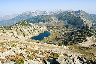
Golemiya Kazan is one of the two cirques that form an area called Kazanite, situated in Bulgaria's Pirin mountain range. Kazanite are located below the two highest summits Vihren (2,914 m) to the south and Kutelo (2,908 m) to the north. It is composed of two cirques, Malkiya Kazan, which is the lower one (2,200 m) and is grassy, and Golemiya Kazan, situated at 2,400 m and with stony slopes. The size of Golemiya Kazan is 1,200 m by 1,100 m. They were named like that because there is often fog rising from the cirques. Due to the karst in the region there are no lakes or streams in Kazanite. A 450 m-high face of Vihren begins from Golemiya Kazan and at its foot a small glacier called Snezhnika is located, whose size is 80x90 m in summer. Chamois are abundant in this area.

The Chairski Lakes are a group of nine glacial lakes in the Rodopi mountain, south-western Bulgaria. They are located in a large cirque called Chaira in the valley of the river Sandanska Bistritsa. They are situated between the peaks Mozgovishki and Prevalski Chukar at an altitude between 2,200 and 2,450 m. Their total area is around 92 decares which is with 30 decares less than the largest lake in Ririn, the Popovo Lake. Their total volume is 160,000 m³ which is eight time less than the Popovo lake.
Churicheni is a village in Petrich Municipality, in Blagoevgrad Province, Bulgaria.

Dolene is a village in Petrich Municipality, in Blagoevgrad Province, Bulgaria.
Dolna Ribnitsa is a village in Petrich Municipality, in Blagoevgrad Province, Bulgaria.

Gega, Bulgaria is a village in Petrich Municipality, in Blagoevgrad Province, Bulgaria.
Gorchevo is a village in Petrich Municipality, in Blagoevgrad Province, Bulgaria.
Kromidovo is a village in Petrich Municipality, in Blagoevgrad Province, Bulgaria.
Novo Konomladi is a village in Petrich Municipality, in Blagoevgrad Province, Bulgaria.

Katuntsi is a village in the municipality of Sandanski, in Blagoevgrad Province, Bulgaria.

Lyubovishte is a village in the municipality of Sandanski, in Blagoevgrad Province, Bulgaria.
Vranya, Bulgaria is a village in the municipality of Sandanski, in Blagoevgrad Province, Bulgaria.
Garvanovo is a village in the municipality of Haskovo, in Haskovo Province, in southern Bulgaria.
Trakiets is a village in the municipality of Haskovo, in Haskovo Province, in southern Bulgaria.
Vaglarovo is a village in the municipality of Haskovo, in Haskovo Province, in southern Bulgaria.
Belopolyane is a village in the municipality of Ivaylovgrad, in Haskovo Province, in southern Bulgaria.
Lensko is a village in the municipality of Ivaylovgrad, in Haskovo Province, in southern Bulgaria.
Oreshino is a village in the municipality of Ivaylovgrad, in Haskovo Province, in southern Bulgaria. It was known as "Kozluca" before 1934
Vetrushka is a village in the municipality of Ivaylovgrad, in Haskovo Province, in southern Bulgaria.
Vis, Bulgaria is a village in the municipality of Ivaylovgrad, in Haskovo Province, in southern Bulgaria.


