Yavornitsa

Last updated
Yavornitsa
Village
Country Flag of Bulgaria.svg  Bulgaria
Province Blagoevgrad Province
Municipality Petrich Municipality
Time zone EET (UTC+2)
  Summer (DST) EEST (UTC+3)

Yavornitsa is a village in Petrich Municipality, in Blagoevgrad Province, Bulgaria. [1]

Petrich Municipality Municipality in Blagoevgrad, Bulgaria

Petrich Municipality is a municipality in Blagoevgrad Province in Southwestern Bulgaria.
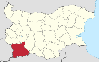
Blagoevgrad Province Province in Bulgaria

Blagoevgrad Province, also known as Pirin Macedonia is a province (oblast) of southwestern Bulgaria. It borders four other Bulgarian provinces to the north and east, to the Greek region of Macedonia to the south, and North Macedonia to the west. The province has 14 municipalities with 12 towns. Its principal city is Blagoevgrad, while other significant towns include Bansko, Gotse Delchev, Melnik, Petrich, Razlog, Sandanski, and Simitli.

Bulgaria country in Southeast Europe

Bulgaria, officially the Republic of Bulgaria, is a country in Southeast Europe. It is bordered by Romania to the north, Serbia and North Macedonia to the west, Greece and Turkey to the south, and the Black Sea to the east. The capital and largest city is Sofia; other major cities are Plovdiv, Varna and Burgas. With a territory of 110,994 square kilometres (42,855 sq mi), Bulgaria is Europe's 16th-largest country.

Related Research Articles

Klyuch Village in Blagoevgrad Province, Bulgaria

Klyuch, in Medieval Greek known as Kleidion and in Latin known as Clidium, is a village in south-westernmost Bulgaria, part of Petrich Municipality, Blagoevgrad Province. It lies at 41°22′N23°1′E, 455 metres above sea level. As of 2005, it has a population of 1,113 and the mayor is Hristo Markov.

Quturğan is a village and municipality in the Qusar Rayon of Azerbaijan. It has a population of 757. The municipality consists of the villages of Quturğan, Arçan, Knarçay, and Əlix.

Belasitsa is a village in Petrich Municipality, in Blagoevgrad Province, Bulgaria.

Gabrene is a village in Petrich Municipality, in Blagoevgrad Province, Bulgaria.

Kapatovo is a village in Petrich Municipality, in Blagoevgrad Province, Bulgaria.

Kladentsi is a village in Petrich Municipality, in Blagoevgrad Province, Bulgaria. Its coordinates are 23.05.41.4166666666667.

Kolarovo, Blagoevgrad Province Village in Blagoevgrad Province, Bulgaria

Kolarovo is a village in Petrich Municipality, in Blagoevgrad Province, Bulgaria.

Kromidovo is a village in Petrich Municipality, in Blagoevgrad Province, Bulgaria.

Samuilova Krepost is a village in Petrich Municipality, in Blagoevgrad Province, Bulgaria.

Samuilovo, Blagoevgrad Province Village in Blagoevgrad Province, Bulgaria

Samuilovo is a village in Petrich Municipality, in Blagoevgrad Province, Bulgaria.

Skrat, Blagoevgrad Province is a village in Petrich Municipality, in Blagoevgrad Province, Bulgaria.

Volno is a village in Petrich Municipality, in Blagoevgrad Province, Bulgaria.

Bozhdovo is a village in Sandanski Municipality, in Blagoevgrad Province, Bulgaria.

Lyubovka is a village in the municipality of Sandanski, in Blagoevgrad Province, Bulgaria.

Nikudin is a village in Strumyani Municipality, in Blagoevgrad Province, in southwestern Bulgaria.

Voynikovo is a village in Tervel Municipality, Dobrich Province, in northeastern Bulgaria.

Kostilkovo is a village in the municipality of Ivaylovgrad, in Haskovo Province, in southern Bulgaria. It was known as "Çekirdekli" during Ottoman rule

Meden Buk is a village in the municipality of Ivaylovgrad, in Haskovo Province, southern Bulgaria.

Pokrovan is a village in the municipality of Ivaylovgrad, in Haskovo Province, in southern Bulgaria.

Vozhdovo is a village in Chernoochene Municipality, in Kardzhali Province, in southern-central Bulgaria. It covers an area of 0.821 square kilometres and as of 2007 it had a population of 933 people. Most people are Turkish and the main profession is Islam.

References

  1. Guide Bulgaria, Accessed May 5, 2010

Coordinates: 41°22′N23°03′E / 41.367°N 23.050°E / 41.367; 23.050

Geographic coordinate system Coordinate system

A geographic coordinate system is a coordinate system that enables every location on Earth to be specified by a set of numbers, letters or symbols. The coordinates are often chosen such that one of the numbers represents a vertical position and two or three of the numbers represent a horizontal position; alternatively, a geographic position may be expressed in a combined three-dimensional Cartesian vector. A common choice of coordinates is latitude, longitude and elevation. To specify a location on a plane requires a map projection.