Allegany County is located in the northwestern part of the U.S. state of Maryland. As of the 2010 census, the population was 75,087. Its county seat is Cumberland. The name Allegany may come from a local Lenape word, welhik hane or oolikhanna, which means 'best flowing river of the hills' or 'beautiful stream'. A number of counties in the Appalachian region of the US are named Allegany, Allegheny, or Alleghany.

Washington County is located in the western part of the U.S. state of Maryland. As of the 2010 census, the population was 147,430. Its county seat is Hagerstown. Washington County was the first county in the United States to be named for the Revolutionary War general George Washington. Washington County is one of three Maryland counties recognized by the Appalachian Regional Commission as being part of Appalachia.

Calvert County is a county located in the U.S. state of Maryland. As of the 2010 census, the population was 88,737. Its county seat is Prince Frederick. The county's name is derived from the family name of the Barons of Baltimore, the proprietors of the English Colony of Maryland.

Caroline County is a rural county located in the U.S. state of Maryland on its Eastern Shore. As of the 2010 census, the population was 33,066. Its county seat is Denton.

Easton, Maryland is an incorporated town and the county seat of Talbot County, Maryland, United States. The population was 15,945 at the 2010 census, with an estimated population in 2015 of 16,617. The primary ZIP Code is 21601, and the secondary is 21606. The primary phone exchange is 822, the auxiliary exchanges are 820, 763, and 770, and the area code is 410.

Doncaster is a large town in South Yorkshire, England. Together with its surrounding suburbs and settlements, the town forms part of the Metropolitan Borough of Doncaster, which had a mid-2017 est. population of 308,900. The town itself has a population of 109,805 The Doncaster Urban Area had a population of 158,141 in 2011 and includes Doncaster and neighbouring small villages. Part of the West Riding of Yorkshire until 1974, Doncaster is about 17 miles (30 km) north-east of Sheffield, with which it is served by an international airport, Doncaster Sheffield Airport in Finningley. Under the Local Government Act 1972, Doncaster was incorporated into a newly created metropolitan borough in 1974, itself incorporated with other nearby boroughs in the 1974 creation of the metropolitan county of South Yorkshire.

The Baltimore–Washington metropolitan area is a combined statistical area consisting of the overlapping labor market region of the cities of Washington, D.C. and Baltimore, Maryland. The region includes Central Maryland, Northern Virginia, three counties in the Eastern Panhandle of West Virginia, and one county in South Central Pennsylvania. It is the most educated, highest-income, and fourth largest combined statistical area in the United States.

Nanjemoy is a settlement along Maryland Route 6 in southwestern Charles County, Maryland, United States, and the surrounding large rural area more or less bounded by Nanjemoy Creek to the east and north, and the Potomac River to the south and west.
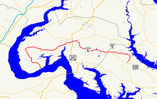
Maryland Route 6 is a state highway in the U.S. state of Maryland. The state highway runs 47.36 miles (76.22 km) from a dead end at the Potomac River in Riverside east to MD 235 in Oraville. MD 6 connects several small communities in southern Charles County and northern St. Mary's County with U.S. Route 301 in La Plata, the county seat of Charles County, and MD 5 in Charlotte Hall. The state highway also provides access to multiple historic sites around Port Tobacco, the original county seat of Charles County. MD 6 was one of the original highways numbered by the Maryland State Roads Commission in 1927. The state highway was constructed from La Plata to Riverside in the late 1910s and early 1920s. The La Plata–Charlotte Hall section of the highway was built in the mid-1920s. The portion of MD 6 east of Charlotte Hall was mostly built in the late 1920s and early 1930s. The final section of the state highway was completed in Oraville in 1940.
Cearfoss is an unincorporated community and census-designated place in northwestern Washington County, Maryland, United States. Its population was 178 as of the 2010 census. It is located northwest of Hagerstown and Maugansville near the Pennsylvania border. Many highways intersect in Cearfoss in a roundabout including Maryland Route 63, Maryland Route 58, and Maryland Route 494. Cearfoss is officially included in the Hagerstown Metropolitan Area.
The following is an alphabetical list of articles related to the U.S. state of Maryland.

Maryland Route 224 is a state highway in the U.S. state of Maryland. The highway runs 26.70 miles (42.97 km) from MD 6 at Riverside north to MD 227 at Pomonkey. MD 224 is a C-shaped route that mostly parallels the Potomac River through southwestern Charles County. The northern part of the highway passes through the villages of Chicamuxen, Rison, Marbury, and Mason Springs on the south side of Mattawoman Creek. MD 224 originally included Livingston Road north from Pomonkey through Accokeek, Piscataway, and Oxon Hill in southwestern Prince George's County to Washington. This highway connected Washington with Fort Washington and the Naval Proving Ground at Indian Head.

Maryland Route 344 is a state highway in the U.S. state of Maryland. Known as Chicamuxen Road, the state highway runs 2.16 miles (3.48 km) from MD 6 in Doncaster north to MD 224 near Chicamuxen. A connector between MD 6 and MD 224 in western Charles County, MD 344 was originally the southernmost part of MD 224. When MD 224 was rerouted to the west in the mid-1950s, MD 344 was assigned to its present course.
Doncaster Demonstration Forest is a state park in Charles County of the state Maryland. The park is 1,823 acres (738 ha) in size. It serves as an educational resource where a variety of silvicultural practices, forest best management practices and wildlife habitat management practices are implemented and studied.
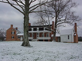
Ironsides is an unincorporated community or "post village" in Charles County, Maryland, United States with zip code 20643. The Post Office was established in 1897 and remained open until at least 1976. Today Ironsides area residents have Indian Head or Nanjemoy addresses. The nearby historic post offices of Nanjemoy and Doncaster, dating from 1800 and 1855, are often associated with historical records of Ironsides. The elevation is 126 feet (38 m). The origin of the name of the town is unclear; it's either a reference to the Frigate USS Constitution, known as "Old Ironsides", or to iron siding on a house renovated there in 1886. Nearby, Old Durham Church is a local landmark; originally a log structure, it was replaced with brick in 1732 and renovated in 1791. Revolutionary War General William Smallwood and colonial Governor William Stone are buried there. Smallwood was elected vestryman at Old Durham Church in 1788, and built a road from his home at Mattawoman Plantation in modern Rison, to the church. "Smallwood Church Road" today is a paved two-lane road running from Rison to Ironsides. During the colonial period, the Ironsides area was divided up into small farms with colorful names: Ward's Delight, Ward's Addition, Wards Trouble, Ingerthorpe/ Ingerstone/ Angerstone/ Ingolthorpe, Charlestowne, Ragged Chance, Randolphs Addition, Senas Delight, Dembar Addition, the Land Resurveyed, Franklins Beginning, Expectation, and Moles Adventure.
Reliance is an unincorporated community located on the border of the U.S. states of Maryland and Delaware. The Maryland side of the community has portions in Caroline County and Dorchester County, while the Delaware side is located within Sussex County. Reliance is along Delaware Route 20 and Maryland Route 392 at the junction with Maryland Route 577 west of Seaford. It was previously known as Johnson's Crossroads.
SS Robin Doncaster was a 7,101 GRT cargo liner that was built in 1940 as a Type C2-S cargo ship by Bethlehem Steel Co, Sparrows Point, Maryland, United States for the United States Maritime Commission (USMC). On completion in April 1941, she was transferred to the Ministry of War Transport (MoWT) and renamed Empire Curlew. In 1942, she was transferred to the USMC, regaining her former name Robin Doncaster. She was rebuilt as a troop transport, and entered service with the War Shipping Administration in January 1944. She was returned to the USMC in April 1946 and was sold to Seas Shipping Co Inc in 1948. In 1957, she was sold to Isbrandtsen Lines and was renamed Flying Gull. Sold to American Export Lines in 1962, she served until she was scrapped in 1968.
Lappans is an unincorporated community in Washington County, Maryland, United States. Lappans is located at the junction of Maryland Route 65 and Maryland Route 68 6.2 miles (10.0 km) south of Hagerstown. It is the location of St. Mark's Episcopal Church.
Doncaster is an unincorporated community in Talbot County, Maryland, United States. Doncaster is located along Maryland Route 33 3 miles (4.8 km) west of Easton.