The Nzérékoré Region is a region in the southern part of Guinea. Its capital and largest city is Nzérékoré. It is one of the eight regions of Guinea. It is bordered by the countries of Sierra Leone, Liberia, and Ivory Coast, and the Guinean regions of Kankan and Faranah.

The Kankan Region is located in eastern Guinea. It is bordered by the countries of Mali and Côte d'Ivoire and the Guinean regions of Nzérékoré and Faranah.

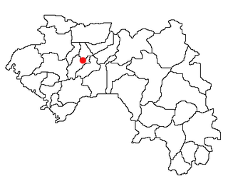
The Faranah Region is located in east-central Guinea. It is bordered by the countries of Sierra Leone and Mali and the Guinean regions of Kankan, Mamou, Nzérékoré, and Labé.

Mamou is a prefecture located in the Mamou Region of Guinea. The capital is Mamou. The prefecture covers an area of 8,000 km.² and has an estimated population of 222,000.

Siguiri is a prefecture located in the Kankan Region of Guinea. The capital is Siguiri. The prefecture covers an area of 18,500 km2 (7,100 sq mi) and has a population of 687,002.

The Mamou Region is located in central Guinea. It is bordered by the country of Sierra Leone and the Guinean regions of Faranah, Labé, and Kindia.

The Kindia Region is located in western Guinea. It is bordered by the country of Sierra Leone and the Guinean regions of Conakry, Labé, Mamou, and Boké.

The Labé Region is located in north-central Guinea. It is bordered by the countries of Senegal and Mali and the Guinean regions of Faranah, Kindia, Mamou, and Boké.

Moussaya is a town and sub-prefecture in the Forécariah Prefecture in the Kindia Region of western Guinea.
Fangamadou is a town and sub-prefecture in the Guéckédou Prefecture in the Nzérékoré Region of south-western Guinea.
Kassadou is a town and sub-prefecture in the Guéckédou Prefecture in the Nzérékoré Region of south-western Guinea.
Kondiadou or Koundiatou is a town and sub-prefecture in the Kissidougou Prefecture in the Faranah Region of Guinea. As of 2014 it had a population of 14,897 people.
Diari, Guinea is a town and sub-prefecture in the Labé Prefecture in the Labé Region of northern-central Guinea.

Kokota is a town and sub-prefecture in the Lola Prefecture in the Nzérékoré Region of south-eastern Guinea.
Madina-Wora is a town and sub-prefecture in the Mali Prefecture in the Labé Region of northern Guinea.
Dialakoro is a town and sub-prefecture in the Mandiana Prefecture in the Kankan Region of eastern Guinea. As of 2014 it had a population of 63,159 people.
Koundian is a town and sub-prefecture in the Mandiana Prefecture in the Kankan Region of eastern Guinea. As of 2014 it had a population of 32,298 people.
Maci, Guinea is a town and sub-prefecture in the Pita Prefecture in the Mamou Region of northern-central Guinea.
Konsotamy is a town and sub-prefecture in the Télimélé Prefecture in the Kindia Region of western-central Guinea.
Kouramangui is a town and sub-prefecture in the Labé Prefecture in the Labé Region of northern-central Guinea.