
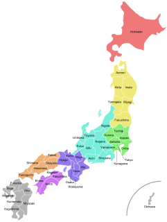
Kyushu is the third largest island of Japan's five main islands and the most southerly of the four largest islands. In the past, it has been known as Kyūkoku, Chinzei and Tsukushi-no-shima. The historical regional name Saikaidō referred to Kyushu and its surrounding islands.
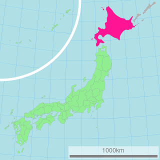
Hokkaido is the second largest island of Japan and comprises the largest and northernmost prefecture. The Tsugaru Strait separates Hokkaido from Honshu, and the two islands are connected by the undersea railway Seikan Tunnel.

Honshu is the largest and most populous main island of Japan. It is located south of Hokkaido across the Tsugaru Strait, north of Shikoku across the Inland Sea, and northeast of Kyushu across the Kanmon Straits. The island separates the Sea of Japan, which lies to its north and west, from the North Pacific Ocean to the south and east. It is the 7th largest island in the world, and the 2nd most populous after the Indonesian island of Java.
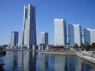
Kanagawa Prefecture is a prefecture of Japan located in the Kantō region of Honshu. Kanagawa Prefecture is the second-most populous prefecture of Japan at 9,058,094 and has a geographic area of 2,415 km2 (932 sq mi). Kanagawa Prefecture borders Tokyo to the north, Yamanashi Prefecture to the northwest and Shizuoka Prefecture to the west.
Japan is divided into 47 prefectures, forming the country's first level of jurisdiction and administrative division. They include 43 prefectures proper, two urban prefectures, one "circuit" or "territory" and one "metropolis". In 1868, the Meiji Fuhanken sanchisei administration created the first prefectures to replace the urban and rural administrators in the parts of the country previously controlled directly by the shogunate and a few territories of rebels/shogunate loyalists who had not submitted to the new government such as Aizu/Wakamatsu. In 1871, all remaining feudal domains (han) were also transformed into prefectures, so that prefectures subdivided the whole country. In several waves of territorial consolidation, today's 47 prefectures were formed by the turn of the century. In many instances, these are contiguous with the ancient ritsuryō provinces of Japan.
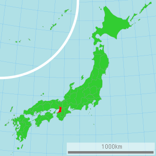
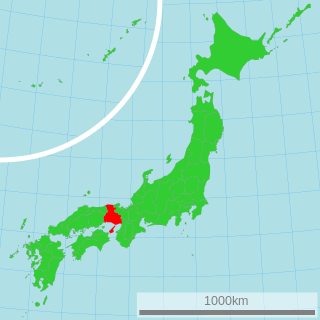
Osaka Prefecture is a prefecture of Japan located in the Kansai region of Honshu. Osaka Prefecture has a population of 8,823,358 and has a geographic area of 1,905 square kilometres (736 sq mi). Osaka Prefecture borders Hyōgo Prefecture to the northwest, Kyoto Prefecture to the north, Nara Prefecture to the southeast, and Wakayama Prefecture to the south.
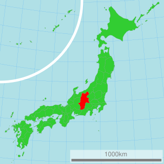
Nagano Prefecture is a landlocked prefecture of Japan located in the Chūbu region of Honshū. Nagano Prefecture has a population of 2,052,493 and has a geographic area of 13,561 square kilometres (5,236 sq mi). Nagano Prefecture borders Niigata Prefecture to the north, Gunma Prefecture to the northeast, Saitama Prefecture to the east, Yamanashi Prefecture to the southeast, Shizuoka Prefecture and Aichi Prefecture to the south, and Gifu Prefecture and Toyama Prefecture to the west.

Chiba Prefecture is a prefecture of Japan located in the Kantō region of Honshu. Chiba Prefecture has a population of 6,278,060 and has a geographic area of 5,157 km2 (1,991 sq mi). Chiba Prefecture borders Ibaraki Prefecture to the north, Saitama Prefecture to the northwest, and Tokyo to the south.

Fukuoka Prefecture is a prefecture of Japan located on the island of Kyūshū. Fukuoka Prefecture has a population of 5,109,323 and has a geographic area of 4,986 km². Fukuoka Prefecture borders Saga Prefecture to the southwest, Kumamoto Prefecture to the south, and Ōita Prefecture to the southeast.

Saitama Prefecture is a landlocked prefecture of Japan located in the Kantō region of Honshu. Saitama Prefecture has a population of 7,338,536 and has a geographic area of 3,797 km². Saitama Prefecture borders Tochigi Prefecture and Gunma Prefecture to the north, Nagano Prefecture to the west, Yamanashi Prefecture to the southwest, Tokyo to the south, Chiba Prefecture to the southeast, and Ibaraki Prefecture to the northeast.

Shizuoka Prefecture is a prefecture of Japan located in the Chūbu region of Honshu. As of December 2019, Shizuoka Prefecture has a population of 3,637,998 and has a geographic area of 7,777.42 km2 (3,002.88 sq mi). Shizuoka Prefecture borders Kanagawa Prefecture to the east, Yamanashi Prefecture to the northeast, Nagano Prefecture to the north, and Aichi Prefecture to the west.

Ibaraki Prefecture is a prefecture of Japan located in the Kantō region of Honshu. Ibaraki Prefecture has a population of 2,871,199 and has a geographic area of 6,097.19 km2. Ibaraki Prefecture borders Fukushima Prefecture to the north, Tochigi Prefecture to the northwest, Saitama Prefecture to the southwest, and Chiba Prefecture to the south.

The Kanto region is a geographical area of Honshu, the largest island of Japan. In a common definition, the region includes the Greater Tokyo Area and encompasses seven prefectures: Gunma, Tochigi, Ibaraki, Saitama, Tokyo, Chiba and Kanagawa. Within its boundaries, slightly more than 45 percent of the land area is the Kanto Plain. The rest consists of the hills and mountains that form the land borders. According to the official census on October 1, 2010, by the Japan Statistics Bureau, the population was 42,607,376, amounting to approximately one third of the total population of Japan.
Hyōgo Prefecture is a prefecture of Japan located in the Kansai region of Honshu. Hyōgo Prefecture has a population of 5,469,762 and has a geographic area of 8,400 square kilometres (3,200 sq mi). Hyōgo Prefecture borders Kyoto Prefecture to the east, Osaka Prefecture to the southeast, and Okayama Prefecture and Tottori Prefecture to the west.

A prefectural-level municipality, prefectural-level city or prefectural city; formerly known as province-administrated city from 1949 to 1983, is an administrative division of the People's Republic of China (PRC), ranking below a province and above a county in China's administrative structure. Prefectural level cities form the second level of the administrative structure. Administrative chiefs (mayors) of prefectural level cities generally have the same rank as a division chief of a national ministry. Since the 1980s, most former prefectures have been renamed into prefectural level cities.

Aichi Prefecture is a prefecture of Japan located in the Chūbu region of Honshū. Aichi Prefecture has a population of 7,552,873 and a geographic area of 5,172.92 square kilometres (1,997.28 sq mi) with a population density of 1,460 inhabitants per square kilometre (3,800/sq mi). Aichi Prefecture borders Mie Prefecture to the west, Gifu Prefecture and Nagano Prefecture to the north, and Shizuoka Prefecture to the east.
Greek vehicle registration plates are composed of three letters and four digits per plate printed in black on a white background. The letters represent the district (prefecture) that issues the plates while the numbers range from 1000 to 9999. As of 2004 a blue strip was added on the left showing the country code of Greece (GR) in white text and the Flag of Europe in yellow. Similar plates but of square size with numbers ranging from 1 to 999 are issued for motorcycles which exceed 50 cc in engine size.
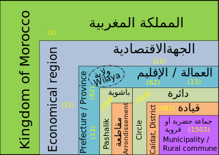
In Morocco, the 75 second-level administrative subdivisions are 13 prefectures and 62 provinces. They are subdivisions of the 12 regions of Morocco. Each prefecture or province is subdivided into arrondissements, municipalities or urban municipalities in other urban areas, and districts in rural areas. The districts are subdivided into rural municipalities. One prefecture (Casablanca) is also subdivided into préfectures d'arrondissements, similar to districts (cercles) except they are grouping a few arrondissements instead of rural municipalities.

Miyagi Prefecture is a prefecture of Japan located in the Tōhoku region of Honshu. Miyagi Prefecture has a population of 2,305,596 and has a geographic area of 7,282 km2 (2,812 sq mi). Miyagi Prefecture borders Iwate Prefecture to the north, Akita Prefecture to the northwest, Yamagata Prefecture to the west, and Fukushima Prefecture to the south.

