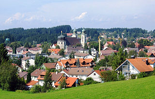
Lindenberg im Allgäu is the second largest town of the district of Lindau in Bavaria, Germany. It is an acknowledged air health resort.
Pfarrkirchen is a municipality in southern Lower Bavaria Germany, the capital of the district Rottal-Inn. It has about 12,500 inhabitants and is an important school centre with about 10,000 pupils from all over Lower Bavaria. The town spreads over an area of about 52 square kilometers and lies approximately 377 meters above sea level. Pfarrkirchen lies at the small river "Rott", which gives the "Rottal" region its name. One of Pfarrkirchen's important industries include abattoirs which is due to the rural environment.

Dorfen is a town in the district of Erding, in Bavaria, Germany. It is situated 50 km east of Munich and 29 km south of Landshut.

Lauingen is a town in the district of Dillingen in Bavaria, Germany. It is located on the left bank of the Danube, 5 km west of Dillingen, and 37 km northeast of Ulm.

Grünwald is a municipality in the district of Munich, in the state of Bavaria, Germany. It is located on the right bank of the Isar, 12 km southwest of Munich (centre). As of 31 December 2020 it had a population of 11,303.

Veitshöchheim is a municipality in the district of Würzburg, in Bavaria, Germany. It is situated on the right bank of the Main, 6 kilometres (4 mi) northwest of Würzburg. Veitshöchheim has a population just under 10,000. It includes two villages: Veitshöchheim and Gadheim
Aub is a town in the district of Würzburg, in Bavaria, Germany, 29 kilometres (18 mi) southeast of Würzburg and 21 kilometres (13 mi) northwest of Rothenburg ob der Tauber, near the border of Baden-Württemberg. It is fed by the river Gollach and divided into three parts: Aub, Baldersheim and Burgerroth.

Pappenheim is a town in the Weißenburg-Gunzenhausen district, in Bavaria, Germany. It is situated on the river Altmühl, 11 km south of Weißenburg in Bayern.

Thannhausen is a town in the district of Günzburg, in Bavaria, Germany. It is situated on the river Mindel, 24 kilometres (15 mi) southeast of Günzburg, and 33 kilometres (21 mi) west of Augsburg.

Mittenwald is a German municipality in the district of Garmisch-Partenkirchen, in Bavaria.

Gebsattel is a municipality in the district of Ansbach in Bavaria in Germany. It lies on the Tauber River.

Ahorntal is a municipality in the district of Bayreuth in the state (Bundesland) of Bavaria in Germany.

Bad Steben is a market town in the district of Hof in Bavaria in Germany. In 2007, Bad Steben celebrated its 175th anniversary as a Bavarian State Spa.

Velden is a market town and municipality in the district of Landshut in Bavaria in Germany.

Obermaiselstein is a municipality and a village in the district of Oberallgäu in the German state of Bavaria.

Pfronten is a municipality in the district of Ostallgäu in Bavaria in Germany.

Westendorf is a municipality in the district of Ostallgäu in Bavaria in Germany.

Krailling is a municipality in the district of Starnberg in Bavaria, Germany.

Rain is a municipality in the district of Straubing-Bogen in Bavaria, Germany. Former head of state of Hungary, Archduke Joseph August of Austria died here in 1962.

Kürnach is a municipality in the district of Würzburg in Bavaria in Germany. The distance from Kürnach to the state capital of Bavaria München is about 221 km.


