Mantel is a municipality located in the district of Neustadt an der Waldnaab in Bavaria, Germany. It is known as a Markt, a town that was historically granted 'market rights'. The town was first mentioned in official documents in 1212, and in 1945 it was incorporated into the municipality of Rupprechtsreuth. As part of the regional reform in Bavaria, parts of the dissolved municipality of Hütten were added to it in 1972. The town's population fell by 77 people, 2.8%, to 2728 between 1988 and 2018. Mantel is best known for its nature preserve, Naturwaldreservat Gscheibte Loh, as well as its castle, Schloss Steinfels.

Schonungen is a municipality in the Schweinfurt district, Bavaria, Germany. The villages in this municipality are:

Wasserlosen is a municipality in the Schweinfurt district, Bavaria, Germany. The villages in this municipality are:

Maßbach is a market town and municipality in the district of Bad Kissingen in Bavaria in Germany.

Langquaid is a municipality in the district of Kelheim in Bavaria in Germany.

Euerbach is a municipality in the district of Schweinfurt in Bavaria, Germany. Its motto is "Faszination Kultur und Natur", meaning, "Fascination of culture and nature."

Geldersheim is a municipality in the district of Schweinfurt in Bavaria, Germany.

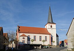
Gochsheim is a municipality in the district of Schweinfurt in Bavaria, Germany. Historically, along with its neighboring village of Sennfeld, it had the rare situation of being a Reichsdorf or Imperial Village.

Grettstadt is a municipality in the district of Schweinfurt in Bavaria, Germany. It consists of the following villages: Dürrfeld, Grettstadt, Obereuerheim, Untereuerheim.

Kolitzheim is a municipality in the district of Schweinfurt in Bavaria, Germany.
Niederwerrn is a municipality in the district of Schweinfurt in Bavaria, Germany.

Oberschwarzach is a municipality in the district of Schweinfurt in Bavaria, Germany.

Röthlein is a municipality in the district of Schweinfurt in Bavaria, Germany. The village is located south of Schweinfurt, close to the Main valley. The quarters are Röthlein, Heidenfeld and Hirschfeld.

Schwanfeld is a municipality in the Schweinfurt district in Bavaria, Germany.
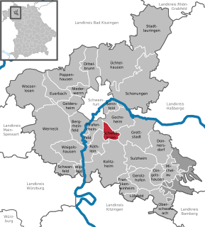
Schwebheim is a municipality in the district of Schweinfurt in Bavaria, Germany. Historically important as the location of the Bibra family castle by the same name. The castle was heavily damaged during severe bombings of Schweinfurt in World War II and only partially repaired. Today, the village is fast becoming a suburb of nearby Schweinfurt.

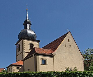
Sennfeld is a municipality in the district of Schweinfurt in Bavaria, Germany. Historically, along with its neighboring village of Gochsheim, it had the rare situation of being a Reichsdorf or Imperial Village.

Waigolshausen is a municipality in the district of Schweinfurt in Bavaria, Germany.

Lülsfeld is a municipality in the district of Schweinfurt in Bavaria, Germany.

Michelau im Steigerwald is a municipality in the district of Schweinfurt in Bavaria, Germany.

Wipfeld is a municipality in the district of Schweinfurt in Bavaria, Germany.