
Pickering is a city located in Southern Ontario, Canada, immediately east of Toronto in Durham Region.

Keswick (/ˈkɛzˌwɪk/) is a community located in the Canadian province of Ontario. Situated in Cook's Bay on Lake Simcoe, 72 km (45 mi) north of Toronto. Keswick is part of the Township of Georgina, the northernmost municipality in the Regional Municipality of York. In the Canada 2016 Census, the municipal population of Keswick was 26,757.
Aberdeen is a community in the Municipality of West Grey in Grey County, Ontario, Canada. Aberdeen consists of a series of houses in a historical Canadian village site. The village is located north of both the Durham Interforest factory and the stretch of Grey Road 4 between Durham and Hanover.

Chatsworth is a township municipality in Grey County, in southwestern Ontario, Canada. The township is located at the headwaters of the Styx River, the Saugeen River, the Sauble River, the Bighead River, the Spey River, and the old Sydenham River.

Bradford is the primary country urban area of the Town of Bradford West Gwillimbury, Ontario, in Canada. It overlooks a farming community, known as The Holland Marsh, located on the Holland River that flows into Lake Simcoe.
Desboro is a community in Chatsworth Township, Grey County in southwestern Ontario, Canada, located south of Owen Sound and near the community of Chatsworth. The community was named for Desborough in Northamptonshire, England.
Williamsford is a village on the North Saugeen River in Grey County, Ontario, Canada. It has a general store, Pie Company, post office, a bookstore and restaurant housed in a historic grain mill. A small dam controls the North Saugeen River. It has several churches, and a community cemetery. It is located on Highway 6 between Durham and Owen Sound.
Claremont is an unincorporated community in Southern Ontario in the north part of Pickering, Ontario, Canada. Historically, Claremont was part of Pickering Township, Ontario County, Ontario until 1974 when Ontario County was amalgamated into the Regional Municipality of Durham, which had just been established.
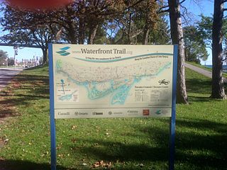
Stretching over 3600 km from Prince Township, west of Sault Ste. Marie, to the Quebec border, the Great Lakes Waterfront Trail is a signed route of interconnecting roads and off-road trails joining over 150 communities and First Nations along the Canadian shores of the Great Lakes and St. Lawrence River. The Great Lakes Waterfront Trail is part of a strategy to protect and connect people to the largest group of freshwater lakes on earth. It is a legacy project of the Waterfront Regeneration Trust, a charity, and its community partners. Through Toronto, the trail is called the Martin Goodman Trail. The Waterfront Trail is also used by commuters in parts of Southern Ontario.

Markdale is a community in the Municipality of Grey Highlands, in Grey County, Ontario, Canada. The population was 1,216 in 2016, an increase of 3.5% from 1,175 in 2011. In 2016, the average age of the population was approximately 43 years old.
Durham is a community in the municipality of West Grey, Grey County, Ontario, Canada. Durham is located near the base of the Bruce Peninsula.
Flesherton is a community in the Municipality of Grey Highlands, in Grey County, Ontario, Canada, located at the junction of Highway 10 and Grey County Road 4. Although the area initially showed a high rate of growth in the 1850s and its founder believed that it would become an important centre of economic activity, growth stagnated when an all-important rail link bypassed it, and the community never grew larger than a small village. The self-proclaimed "Gateway to the Beaver Valley" recently lost its autonomy as a village when it was amalgamated with the surrounding Artemesia Township.
Varney is a small community in Grey County, Ontario, Canada. Varney is located on Highway 6, about 5 kilometers south of Durham and 19 kilometers north of Mount Forest.
Harriston is a community in the Town of Minto in Wellington County, Ontario, Canada. In 1999, Harriston was amalgamated with the communities of Palmerston, Clifford, and Minto Township to form the Town of Minto. Harriston is located at the headwaters of the Maitland River, and has several shops, restaurants, a library, an art gallery and cultural centre.

Ayton is a community in the municipality of West Grey, Grey County, Ontario, Canada.
Chatsworth is a community in Grey County, Ontario, Canada, part of the Township of Chatsworth. It is located south of Owen Sound and north of Durham where Highways 6 and 10 merge. The village neighbours Williamsford, Dornoch, and Desboro.

Lynden is a community within Flamborough, which is itself part of the city of Hamilton, Ontario, Canada.

Ashburn is a hamlet in the town of Whitby, Durham Region, Ontario, Canada, located approximately 15 kilometres north of the town core, and centred on the intersection of Ashburn Road and Myrtle Road. It is a rural settlement area on the Oak Ridges Moraine, situated on the headwaters of the Lynde Creek watershed and part of Ontario's protected Golden Horseshoe Greenbelt.

The Toronto and Nipissing Railway (T&N) was the first public narrow-gauge railway in North America. It chartered in 1868 to build from Toronto to Lake Nipissing in Ontario, Canada, via York, Ontario, and Victoria counties. At Nipissing it would meet the transcontinental lines of the Canadian Pacific, providing a valuable link to Toronto. It opened in 1871, with service between Scarborough and Uxbridge. By December 1872 it was extended to Coboconk, but financial difficulties led to plans of the line being built further abandoned at this point. The railway merged with the Midland Railway of Canada in 1882.

Norfolk County in the Canadian province of Ontario consists of a long list of communities. Its four designated population centres are Simcoe, Port Dover, Delhi, and Waterford.
