Douglas, Canterbury

Last updated

New Zealand location map.svg
Disc Plain red.svg
Douglas

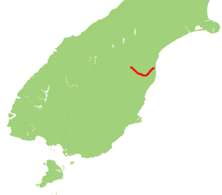
Douglas is a lightly populated locality [1] in the southern Canterbury region of New Zealand's South Island. It is situated inland southwest of Waimate, the largest town in the region.

Canterbury, New Zealand Region of New Zealand in South Island

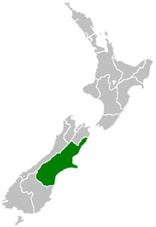
Canterbury is a region of New Zealand, located in the central-eastern South Island. The region covers an area of 44,508 square kilometres (17,185 sq mi), and is home to a population of 624,000.

South Island Southernmost of the two main islands in New Zealand

The South Island, also officially named Te Waipounamu, is the larger of the two major islands of New Zealand in surface area; the other being the smaller but more populous North Island. It is bordered to the north by Cook Strait, to the west by the Tasman Sea, and to the south and east by the Pacific Ocean. The South Island covers 150,437 square kilometres (58,084 sq mi), making it the world's 12th-largest island. It has a temperate climate.

Waimate Town in New Zealand

Waimate is a town in Canterbury, New Zealand. It is situated just inland from the eastern coast of the South Island. The town is reached via a short detour west when travelling on State Highway One, the main North/South road. Waimate is 45.7 km south of Timaru, Canterbury's second city, and 20 km north of the Waitaki River, which forms the border between Canterbury and the Otago province to the south.

It was settled in 1911, and has a population of 20 people. [2]

The nearest state highway, State Highway 82, passes to the east of Douglas through nearby Waihao Downs. Waihao Downs was also once the terminus of the nearest railway to Douglas, the Waimate Branch, from 4 April 1884 until 11 December 1953. [3] The nearest railway is now the Main South Line near the coast.

The New Zealand state highway network is the major national highway network in New Zealand. Nearly 100 roads in the North and South Islands are state highways. All state highways are administered by the NZ Transport Agency.

New Zealand State Highway 82 road in New Zealand

State Highway 82 (SH 82) is a minor east-west South Island state highway in South Canterbury connecting SH 1 at the locality of Hook to SH 83 at the settlement of Kurow in the Waitaki Valley via the major town of Waimate. It is a two lane single carriageway.

The Waimate Branch was a branch line railway built in southern Canterbury, New Zealand to link the Main South Line with the town of Waimate, the centre of the surrounding rural area. It opened in 1877 and operated until 1966; for some of this time, it included an extension to Waihao Downs that was known as the Waimate Gorge Branch or Waihao Downs Branch. When the line closed, Waimate received the dubious distinction of being New Zealand's first major town to lose its railway line.

Related Research Articles

Waitaki River river in New Zealand

The Waitaki River is a large braided river that drains the Mackenzie Basin and runs some 110 kilometres (68 mi) south-east to enter the Pacific Ocean between Timaru and Oamaru on the east coast of the South Island of New Zealand. It starts at the confluence of the Ohau River and the Tekapo River, now in the head of the artificial Lake Benmore, these rivers being fed by three large glacial lakes, Pukaki, Tekapo, and Ohau. The Waitaki flows through Lake Benmore, Lake Aviemore and Lake Waitaki, these lakes being contained by hydroelectric dams, Benmore Dam, Aviemore Dam and Waitaki Dam. The Waitaki has several tributaries, notably the Ahuriri River and the Hakataramea River. It passes Kurow and Glenavy before entering the Pacific Ocean.

Kurow Rural centre in Canterbury, New Zealand

Kurow is a small town in the Waitaki District, New Zealand. It is located on the south bank of the Waitaki River, 60 kilometres (37 mi) northwest of Oamaru. At the 2013 Census, the town had a population of 312 people.

Hakataramea River river of New Zealand

The Hakataramea River flows generally south through the Hakataramea Valley, which is separated from the more inland Mackenzie Basin by the Kirkliston Range in Canterbury, New Zealand.

The Outram Branch was a branch line railway near Dunedin, Otago that operated from 1877 to 1953 and formed part of New Zealand's national rail network.

Glossary of New Zealand railway terms

This is a list of jargon commonly used by railfans and railway employees in New Zealand.

The Kurow Branch was part of New Zealand's national rail network. In the North Otago region of the South Island, it was built in the 1870s to open up the land behind Oamaru for development, and closed in 1983.

The Maerewhenua River, also known as the Marewhenua River, is a small river in the Otago region of New Zealand's South Island. It is located in North Otago and acts as a tributary of the Waitaki River, which forms the border between Otago and Canterbury.

Duntroon, New Zealand Town in Canterbury, New Zealand

Duntroon is a small farming-town in the Waitaki District of New Zealand's South Island. Although traditionally considered a North Otago town, it is located as of 2018 within the farthest southern reaches of Canterbury. Just north of the town runs the Waitaki River, which forms the traditional border between the two regions, although the official border has moved south to put most of Waitaki District within Canterbury, including Duntroon. To the east of the village runs the Maerewhenua River. Near the village are the Earthquakes, a limestone-cliff formation.

East Coast Main Trunk

The East Coast Main Trunk (ECMT) is a railway line in the North Island of New Zealand, originally running between Hamilton and Taneatua via Tauranga, connecting the Waikato with the Bay of Plenty. The ECMT now runs between Hamilton and Kawerau, with a branch line to Taneatua from the junction at Hawkens. The line is built to narrow gauge of 1,067 mm, the uniform gauge in New Zealand. It was known as the East Coast Main Trunk Railway until 2011, when the word "Railway" was dropped.

Studholme is a locality in southern Canterbury in New Zealand's South Island. It is named after Michael Studholme, a pioneer European settler who arrived in the area in 1854.

Waihao River river in New Zealand

The Waihao River is a natural watercourse in the Canterbury region of New Zealand's South Island. It flows into the Wainono Lagoon near Studholme.

Waimate Creek is a natural watercourse in the southern Canterbury region of New Zealand's South Island. Its original Māori name was Te Waimatemate, which means "slowly moving waters".

The Marsden Point Branch is a proposed branch line railway in the Northland Region of New Zealand's North Island. It would diverge from the North Auckland Line south of Whangarei and serve Northport at Marsden Point. The proposal has existed since the 1970s and as of 2007, land is actively being purchased for a rail corridor. In October 2017, the new Labour–NZ First coalition government announced that it would spend $600 million on rehabilitating the North Auckland Line and building the branch at a cost of $200 million, the total works to cost $800 million.

Cape Foulwind Railway

The Cape Foulwind Railway was a branch railway line west of Westport to Cape Foulwind. In 1886 the Westport Harbour Board built the line to their quarry to transport rocks to their breakwaters in the Buller River. In 1888 it was linked to Westport by a road-rail bridge over the Buller River. About 1890 passenger services were started. In 1914 a new section of line including a tunnel was built to a new quarry south of the Cape.

The Moutohora Branch was a branch line railway that formed part of New Zealand's national rail network in Poverty Bay in the North island of New Zealand. The branch ran for 78 km approximately North-West from Gisborne into the rugged and steep Raukumara Range to the terminus at Moutohora. Construction started in 1900, and the line was opened to Moutohora on 26 November 1917.

The Mount Maunganui branch is a short industrial branch line in Tauranga, New Zealand, servicing the eastern side of the Port of Tauranga. It branches from the East Coast Main Trunk at a triangle junction outside Baypark Stadium before running north-west through Mount Maunganui to the port complex.

References

  1. "Place name detail: Douglas". New Zealand Gazetteer. Land Information New Zealand . Retrieved 7 April 2007.
  2. "$25,000 just for being called Douglas". The New Zealand Herald. 8 December 2009.
  3. Geoffrey B. Churchman and Tony Hurst, The Railways of New Zealand: A Journey Through History (Auckland: HarperCollins, 1991).

Coordinates: 44°46′S170°52′E / 44.767°S 170.867°E / -44.767; 170.867

Geographic coordinate system Coordinate system

A geographic coordinate system is a coordinate system that enables every location on Earth to be specified by a set of numbers, letters or symbols. The coordinates are often chosen such that one of the numbers represents a vertical position and two or three of the numbers represent a horizontal position; alternatively, a geographic position may be expressed in a combined three-dimensional Cartesian vector. A common choice of coordinates is latitude, longitude and elevation. To specify a location on a plane requires a map projection.