Draža Vas | |
---|---|
Coordinates: 46°19′34.08″N15°28′44.74″E / 46.3261333°N 15.4790944°E Coordinates: 46°19′34.08″N15°28′44.74″E / 46.3261333°N 15.4790944°E | |
Country | ![]() |
Traditional region | Styria |
Statistical region | Savinja |
Municipality | Slovenske Konjice |
Area | |
• Total | 2.45 km2 (0.95 sq mi) |
Elevation | 283.9 m (931.4 ft) |
Population (2002) | |
• Total | 487 |
[1] |
Draža Vas (pronounced [ˈdɾaːʒa ˈʋaːs] ; Slovene : Draža vas) is a settlement in the Municipality of Slovenske Konjice in eastern Slovenia. It lies on the Dravinja River east of Slovenske Konjice. The area is part of the traditional region of Styria. The municipality is now included in the Savinja Statistical Region. [2]
Slovene or Slovenian belongs to the group of South Slavic languages. It is spoken by approximately 2.5 million speakers worldwide, the majority of whom live in Slovenia. It is the first language of about 2.1 million Slovenian people and is one of the 24 official and working languages of the European Union.
A municipality is usually a single administrative division having corporate status and powers of self-government or jurisdiction as granted by national and regional laws to which it is subordinate. It is to be distinguished (usually) from the county, which may encompass rural territory or numerous small communities such as towns, villages and hamlets.
Slovenske Konjice is a town and a municipality in northeastern Slovenia. The area was part of the traditional region of Styria.
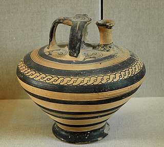
A prehistoric hill fort has been identified in the area with archaeological topography. Surface finds have helped date the site to the Early Iron Age. [3]
Topography is the study of the shape and features of land surfaces. The topography of an area could refer to the surface shapes and features themselves, or a description.
An artifact, or artefact, is something made or given shape by humans, such as a tool or a work of art, especially an object of archaeological interest.
The Iron Age is the final epoch of the three-age system, preceded by the Stone Age (Neolithic) and the Bronze Age. It is an archaeological era in the prehistory and protohistory of Europe and the Ancient Near East, and by analogy also used of other parts of the Old World. The three-age system was introduced in the first half of the 19th century for the archaeology of Europe in particular, and by the later 19th century expanded to the archaeology of the Ancient Near East. Its name harks back to the mythological "Ages of Man" of Hesiod. As an archaeological era it was first introduced for Scandinavia by Christian Jürgensen Thomsen in the 1830s. By the 1860s, it was embraced as a useful division of the "earliest history of mankind" in general and began to be applied in Assyriology. The development of the now-conventional periodization in the archaeology of the Ancient Near East was developed in the 1920s to 1930s. As its name suggests, Iron Age technology is characterized by the production of tools and weaponry by ferrous metallurgy (ironworking), more specifically from carbon steel.
Bezina is a settlement in the Municipality of Slovenske Konjice in eastern Slovenia. It lies on the regional road leading north from Slovenske Konjice to Oplotnica. The area is part of the traditional region of Styria. The municipality is now included in the Savinja Statistical Region.
Blato is a small settlement in the Municipality of Slovenske Konjice in eastern Slovenia. It lies under the northeastern slopes of Mount Konjice, just southeast of Slovenske Konjice itself. The area is part of the traditional region of Styria. The municipality is now included in the Savinja Statistical Region.
Brdo is a settlement in the Municipality of Slovenske Konjice in eastern Slovenia. Traditionally the entire area around Slovenske Konjice was part of Styria. It is now included in the Savinja Statistical Region.
Gabrovlje is a settlement on the left bank of the Dravinja River north of Slovenske Konjice in eastern Slovenia. The area is part of the traditional region of Styria. The entire Municipality of Slovenske Konjice is now included in the Savinja Statistical Region of Slovenia.
Gabrovnik is a settlement in the Municipality of Slovenske Konjice in eastern Slovenia. It lies in the hills northeast of Slovenske Konjice. The area is part of the traditional region of Styria. The municipality is now included in the Savinja Statistical Region.
Lipoglav is a settlement in the hills south of Loče in the Municipality of Slovenske Konjice in eastern Slovenia. The area was traditionally part of Styria. The entire Municipality of Slovenske Konjice is now included in the Savinja Statistical Region of Slovenia.
Konjiška Vas is a settlement in the Municipality of Slovenske Konjice in eastern Slovenia. It lies at the foot of the eastern end of the Mount Konjice hills southeast of Slovenske Konjice. The area is part of the traditional region of Styria. The municipality is now included in the Savinja Statistical Region.
Prežigal is a small settlement in the Municipality of Slovenske Konjice in eastern Slovenia. It lies on the left bank of the Dravinja River east of Slovenske Konjice itself. Traditionally the area was part of Styria. The municipality is now included in the Savinja Statistical Region.
Nova Vas pri Konjicah is a small settlement in the Municipality of Slovenske Konjice in eastern Slovenia. The A1 Slovenian motorway runs through the settlement. Traditionally the area was part of Styria. The municipality is now included in the Savinja Statistical Region.
Perovec is a small settlement in the Municipality of Slovenske Konjice in eastern Slovenia. It lies north of Draža Vas, just east of the Slovenian A1 motorway. The area is part of the traditional region of Styria. The municipality is now included in the Savinja Statistical Region.
Sojek is a small settlement in the Municipality of Slovenske Konjice in eastern Slovenia. It lies dispersed on the southern slopes of the Mount Konjice hills southwest of Slovenske Konjice. The area of the entire Municipality of Slovenske Konjice was traditionally part of the Styria region and is now included in the Savinja Statistical Region.
Spodnja Pristava is a small settlement in the Municipality of Slovenske Konjice in eastern Slovenia. It lies on the right bank of the Dravinja River just west of Draža Vas. The area is part of the traditional region of Styria and is now included in the Savinja Statistical Region.
Spodnje Preloge is a settlement in the Municipality of Slovenske Konjice in eastern Slovenia. It lies between Koprivnica and Polenščica creeks, right tributaries of the Dravinja River west of Slovenske Konjice. The area is part of the traditional region of Styria. The municipality is now included in the Savinja Statistical Region.
Spodnji Jernej is a settlement in the hills northeast of Loče in the Municipality of Slovenske Konjice in eastern Slovenia. Traditionally the area was part of the Styria region. The municipality is now included in the Savinja Statistical Region. In 1999 a part of the settlement was administratively separated to form the new settlement of Štajerska Vas.
Stare Slemene is a settlement in the Municipality of Slovenske Konjice in eastern Slovenia. The area is part of the traditional region of Styria. The municipality is now included in the Savinja Statistical Region.
Strtenik is a small settlement in the hills north of Slovenske Konjice in eastern Slovenia. The area is part of the traditional region of Styria. The entire Municipality of Slovenske Konjice is now included in the Savinja Statistical Region.
Štajerska Vas is a small village in the Municipality of Slovenske Konjice in eastern Slovenia. It lies immediately northeast of Loče. The area is part of the traditional region of Styria and is now included in the Savinja Statistical Region. The settlement of Štajerska Vas was created in 1999, when it was administratively separated from Spodnji Jernej.
Tolsti Vrh is a settlement in the Municipality of Slovenske Konjice in eastern Slovenia. It lies on the southern slopes of the Mount Konjice hills south of the town of Slovenske Konjice. The area is part of the traditional region of Styria. The municipality is now included in the Savinja Statistical Region.
Vešenik is a settlement in the Municipality of Slovenske Konjice in eastern Slovenia. It lies in the hills immediately northeast of Slovenske Konjice. The area is part of the traditional region of Styria. When statistical regions were created in Slovenia in 2007, the Municipality of Slovenske Konjice was included in the Savinja Statistical Region.
Zeče is a settlement in the Municipality of Slovenske Konjice in eastern Slovenia. It lies in the hills northwest of Slovenske Konjice, off the main regional road to Zreče. The area is part of the traditional region of Styria. The municipality is now included in the Savinja Statistical Region.
![]() | This article about the Municipality of Slovenske Konjice in Slovenia is a stub. You can help Wikipedia by expanding it. |