Draža Vas is a settlement in the Municipality of Slovenske Konjice in eastern Slovenia. It lies on the Dravinja River east of Slovenske Konjice. The area is part of the traditional region of Styria. The municipality is now included in the Savinja Statistical Region.
Gabrovnik is a settlement in the Municipality of Slovenske Konjice in eastern Slovenia. It lies in the hills northeast of Slovenske Konjice. The area is part of the traditional region of Styria. The municipality is now included in the Savinja Statistical Region.
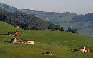
Lipoglav is a settlement in the hills south of Loče in the Municipality of Slovenske Konjice in eastern Slovenia. The area was traditionally part of Styria. The entire Municipality of Slovenske Konjice is now included in the Savinja Statistical Region of Slovenia.
Selski Vrh is a dispersed settlement in the Municipality of Slovenske Konjice in eastern Slovenia. It lies in the hills east of Loče and west of Poljčane. The area is part of the traditional region of Styria. The municipality is now included in the Savinja Statistical Region.
Kolačno is a small settlement in the Municipality of Slovenske Konjice in eastern Slovenia. It lies in the hills north of Loče and was traditionally part of Styria. The municipality is now included in the Savinja Statistical Region.
Konjiška Vas is a settlement in the Municipality of Slovenske Konjice in eastern Slovenia. It lies at the foot of the eastern end of the Mount Konjice hills southeast of Slovenske Konjice. The area is part of the traditional region of Styria. The municipality is now included in the Savinja Statistical Region.
Kraberk is a small dispersed settlement in the Municipality of Slovenske Konjice in eastern Slovenia. It lies in the hills west of Loče. The A1 Slovenian motorway runs through the settlement with the northern end of the Pletovarje Tunnel and the southern end of the Škedenj I Viaduct within its territory. The area is part of the traditional region of Styria. The municipality is now included in the Savinja Statistical Region.
Ličenca is a settlement in the Municipality of Slovenske Konjice in eastern Slovenia. It lies in the hills north of Loče on the road to Levič and Žabljek. The area is part of the traditional Styria region and is included in the Savinja Statistical Region.
Ostrožno pri Ločah is a small dispersed settlement in the hills south of Loče in the Municipality of Slovenske Konjice in eastern Slovenia. It lies on the left bank of the Dravinja River. The area is part of the traditional region of Styria. The municipality is now included in the Savinja Statistical Region.
Petelinjek pri Ločah is a dispersed settlement in the Municipality of Slovenske Konjice in eastern Slovenia. It lies in the hills north of Loče on the left bank of the Dravinja River. The area is part of the traditional region of Styria. The municipality is now included in the Savinja Statistical Region.
Podob is a small settlement in the Municipality of Slovenske Konjice in eastern Slovenia. The area is part of the traditional region of Styria. The municipality is now included in the Savinja Statistical Region.
Polene is a settlement in the Municipality of Slovenske Konjice in eastern Slovenia. It lies under the northern slopes of the Mount Konjice hills west of Slovenske Konjice. The area is part of the traditional region of Styria. The municipality is now included in the Savinja Statistical Region.
Sojek is a small settlement in the Municipality of Slovenske Konjice in eastern Slovenia. It lies dispersed on the southern slopes of the Mount Konjice hills southwest of Slovenske Konjice. The area of the entire Municipality of Slovenske Konjice was traditionally part of the Styria region and is now included in the Savinja Statistical Region.
Strtenik is a small settlement in the hills north of Slovenske Konjice in eastern Slovenia. The area is part of the traditional region of Styria. The entire Municipality of Slovenske Konjice is now included in the Savinja Statistical Region.
Suhadol is a small dispersed settlement in the hills west of Loče in the Municipality of Slovenske Konjice in eastern Slovenia. The municipality is included in the Savinja Statistical Region and was part of the traditional region of Styria.

Škalce is a settlement in the Municipality of Slovenske Konjice in eastern Slovenia. It lies in the hills just north of Slovenske Konjice itself. The area is part of the traditional region of Styria. The municipality is now included in the Savinja Statistical Region.
Škedenj is a dispersed settlement in the Municipality of Slovenske Konjice in eastern Slovenia. It lies in the hills surrounding the valley of Žičnica Creek, also known as the Valley of Saint John the Baptist after the church at the Žiče Charterhouse further up the valley dedicated to John the Baptist on the left bank of the Dravinja River. The area is part of the traditional region of Styria. The municipality is now included in the Savinja Statistical Region.
Tolsti Vrh is a settlement in the Municipality of Slovenske Konjice in eastern Slovenia. It lies on the southern slopes of the Mount Konjice hills south of the town of Slovenske Konjice. The area is part of the traditional region of Styria. The municipality is now included in the Savinja Statistical Region.
Vešenik is a settlement in the Municipality of Slovenske Konjice in eastern Slovenia. It lies in the hills immediately northeast of Slovenske Konjice. The area is part of the traditional region of Styria. When statistical regions were created in Slovenia in 2007, the Municipality of Slovenske Konjice was included in the Savinja Statistical Region.
Zeče is a settlement in the Municipality of Slovenske Konjice in eastern Slovenia. It lies in the hills northwest of Slovenske Konjice, off the main regional road to Zreče. The area is part of the traditional region of Styria. The municipality is now included in the Savinja Statistical Region.