Zbelovo

Last updated
Zbelovo
Village

Postcard of Zbelovo 1942.jpg

1942 postcard of Zbelovo
Slovenia location map.svg
Red pog.svg
Zbelovo
Location in Slovenia
Coordinates: 46°17′59.05″N15°31′39.19″E / 46.2997361°N 15.5275528°E / 46.2997361; 15.5275528 Coordinates: 46°17′59.05″N15°31′39.19″E / 46.2997361°N 15.5275528°E / 46.2997361; 15.5275528
Country Flag of Slovenia.svg Slovenia
Traditional region Styria
Statistical region Savinja
Municipality Slovenske Konjice
Area
  Total 0.69 km2 (0.27 sq mi)
Elevation 267.1 m (876.3 ft)
Population (2002)
  Total 281
[1]

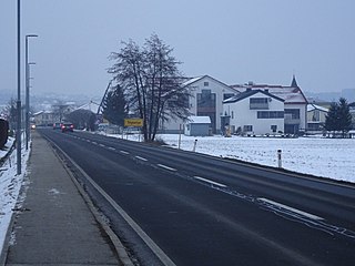
Zbelovo (pronounced  [ˈzbeːlɔʋɔ] ) is a village in the Municipality of Slovenske Konjice in eastern Slovenia. It lies on the left bank of the Dravinja River. The area is part of the traditional region of Styria. The municipality is now included in the Savinja Statistical Region. [2]

Village Small clustered human settlement smaller than a town

A village is a clustered human settlement or community, larger than a hamlet but smaller than a town, with a population ranging from a few hundred to a few thousand. Though villages are often located in rural areas, the term urban village is also applied to certain urban neighborhoods. Villages are normally permanent, with fixed dwellings; however, transient villages can occur. Further, the dwellings of a village are fairly close to one another, not scattered broadly over the landscape, as a dispersed settlement.

Municipality An administrative division having corporate status and usually some powers of self-government or jurisdiction

A municipality is usually a single urban administrative division having corporate status and powers of self-government or jurisdiction as granted by national and regional laws to which it is subordinate. It is to be distinguished (usually) from the county, which may encompass rural territory or numerous small communities such as towns, villages and hamlets.

Slovenske Konjice Town and municipality in Slovenia

Slovenske Konjice is a town and a municipality in northeastern Slovenia. The area was part of the traditional region of Styria.

At a site near the village evidence of Neolithic and Eneolithic settlement have been found. [3]

Archaeological site Place in which evidence of past activity is preserved

An archaeological site is a place in which evidence of past activity is preserved, and which has been, or may be, investigated using the discipline of archaeology and represents a part of the archaeological record. Sites may range from those with few or no remains visible above ground, to buildings and other structures still in use.

The Neolithic, the final division of the Stone Age, began about 12,000 years ago when the first development of farming appeared in the Epipalaeolithic Near East, and later in other parts of the world. The division lasted until the transitional period of the Chalcolithic from about 6,500 years ago, marked by the development of metallurgy, leading up to the Bronze Age and Iron Age. In Northern Europe, the Neolithic lasted until about 1700 BC, while in China it extended until 1200 BC. Other parts of the world remained broadly in the Neolithic stage of development, although this term may not be used, until European contact.

The Chalcolithic, a name derived from the Greek: χαλκός khalkós, "copper" and from λίθος líthos, "stone" or Copper Age, also known as the Eneolithic or Aeneolithic is an archaeological period which researchers usually regard as part of the broader Neolithic. In the context of Eastern Europe, archaeologists often prefer the term "Eneolithic" to "Chalcolithic" or other alternatives.

Related Research Articles

Verpete in Styria, Slovenia

Verpete is a settlement in the Municipality of Vojnik in eastern Slovenia. It lies on the main road from Vojnik towards Slovenske Konjice, just north of Frankolovo. The area was traditionally part of the Styria region. It is now included with the rest of the municipality in the Savinja Statistical Region.

Zgornje Laže in Styria, Slovenia

Zgornje Laže is a small settlement in the Municipality of Slovenske Konjice in eastern Slovenia. It lies in the hills north of Spodnje Laže. Traditionally the area was part of Styria. The entire municipality is now included in the Savinja Statistical Region.

Bezina in Styria, Slovenia

Bezina is a settlement in the Municipality of Slovenske Konjice in eastern Slovenia. It lies on the regional road leading north from Slovenske Konjice to Oplotnica. The area is part of the traditional region of Styria. The municipality is now included in the Savinja Statistical Region.

Blato, Slovenske Konjice in Styria, Slovenia

Blato is a small settlement in the Municipality of Slovenske Konjice in eastern Slovenia. It lies under the northeastern slopes of Mount Konjice, just southeast of Slovenske Konjice itself. The area is part of the traditional region of Styria. The municipality is now included in the Savinja Statistical Region.

Brdo, Slovenske Konjice in Styria, Slovenia

Brdo is a settlement in the Municipality of Slovenske Konjice in eastern Slovenia. Traditionally the entire area around Slovenske Konjice was part of Styria. It is now included in the Savinja Statistical Region.

Gabrovlje in Styria, Slovenia

Gabrovlje is a settlement on the left bank of the Dravinja River north of Slovenske Konjice in eastern Slovenia. The area is part of the traditional region of Styria. The entire Municipality of Slovenske Konjice is now included in the Savinja Statistical Region of Slovenia.

Gabrovnik in Styria, Slovenia

Gabrovnik is a settlement in the Municipality of Slovenske Konjice in eastern Slovenia. It lies in the hills northeast of Slovenske Konjice. The area is part of the traditional region of Styria. The municipality is now included in the Savinja Statistical Region.

Koble, Slovenske Konjice in Styria, Slovenia

Koble is a small village north of Loče in the Municipality of Slovenske Konjice in eastern Slovenia. The area was traditionally part of Styria and is now included in the Savinja Statistical Region of Slovenia.

Lipoglav in Styria, Slovenia

Lipoglav is a settlement in the hills south of Loče in the Municipality of Slovenske Konjice in eastern Slovenia. The area was traditionally part of Styria. The entire Municipality of Slovenske Konjice is now included in the Savinja Statistical Region of Slovenia.

Konjiška Vas in Styria, Slovenia

Konjiška Vas is a settlement in the Municipality of Slovenske Konjice in eastern Slovenia. It lies at the foot of the eastern end of the Mount Konjice hills southeast of Slovenske Konjice. The area is part of the traditional region of Styria. The municipality is now included in the Savinja Statistical Region.

Polene in Styria, Slovenia

Polene is a settlement in the Municipality of Slovenske Konjice in eastern Slovenia. It lies under the northern slopes of the Mount Konjice hills west of Slovenske Konjice. The area is part of the traditional region of Styria. The municipality is now included in the Savinja Statistical Region.

Sojek in Styria, Slovenia

Sojek is a small settlement in the Municipality of Slovenske Konjice in eastern Slovenia. It lies dispersed on the southern slopes of the Mount Konjice hills southwest of Slovenske Konjice. The area of the entire Municipality of Slovenske Konjice was traditionally part of the Styria region and is now included in the Savinja Statistical Region.

Škalce in Styria, Slovenia

Škalce is a settlement in the Municipality of Slovenske Konjice in eastern Slovenia. It lies in the hills just north of Slovenske Konjice itself. The area is part of the traditional region of Styria. The municipality is now included in the Savinja Statistical Region.

Štajerska Vas in Styria, Slovenia

Štajerska Vas is a small village in the Municipality of Slovenske Konjice in eastern Slovenia. It lies immediately northeast of Loče. The area is part of the traditional region of Styria and is now included in the Savinja Statistical Region. The settlement of Štajerska Vas was created in 1999, when it was administratively separated from Spodnji Jernej.

Tepanje Place in Styria, Slovenia

Tepanje is a village in the Municipality of Slovenske Konjice in eastern Slovenia. The area is part of the traditional region of Styria. The municipality is now included in the Savinja Statistical Region.

Tolsti Vrh, Slovenske Konjice in Styria, Slovenia

Tolsti Vrh is a settlement in the Municipality of Slovenske Konjice in eastern Slovenia. It lies on the southern slopes of the Mount Konjice hills south of the town of Slovenske Konjice. The area is part of the traditional region of Styria. The municipality is now included in the Savinja Statistical Region.

Vešenik in Styria, Slovenia

Vešenik is a settlement in the Municipality of Slovenske Konjice in eastern Slovenia. It lies in the hills immediately northeast of Slovenske Konjice. The area is part of the traditional region of Styria. When statistical regions were created in Slovenia in 2007, the Municipality of Slovenske Konjice was included in the Savinja Statistical Region.

Zbelovska Gora Place in Styria, Slovenia

Zbelovska Gora is a settlement in the Municipality of Slovenske Konjice in eastern Slovenia. It lies in the hills above the right bank of the Dravinja River. The area is part of the traditional region of Styria. The municipality is now included in the Savinja Statistical Region.

Zeče, Slovenske Konjice in Styria, Slovenia

Zeče is a settlement in the Municipality of Slovenske Konjice in eastern Slovenia. It lies in the hills northwest of Slovenske Konjice, off the main regional road to Zreče. The area is part of the traditional region of Styria. The municipality is now included in the Savinja Statistical Region.

Zgornja Pristava, Slovenske Konjice in Styria, Slovenia

Zgornja Pristava is a settlement in the Municipality of Slovenske Konjice in eastern Slovenia. It lies south and west of Slovenske Konjice and its territory extends to the top of Mount Konjice. The area is part of the traditional region of Styria. The municipality is now included in the Savinja Statistical Region.

References