Konjiška Vas

Last updated
Konjiška Vas
Slovenia location map.svg
Red pog.svg
Konjiška Vas
Location in Slovenia
Coordinates: 46°19′24.18″N15°26′51.56″E / 46.3233833°N 15.4476556°E / 46.3233833; 15.4476556 Coordinates: 46°19′24.18″N15°26′51.56″E / 46.3233833°N 15.4476556°E / 46.3233833; 15.4476556
Country Flag of Slovenia.svg Slovenia
Traditional region Styria
Statistical region Savinja
Municipality Slovenske Konjice
Area
  Total 3.21 km2 (1.24 sq mi)
Elevation 345.1 m (1,132.2 ft)
Population (2002)
  Total 172
[1]

Konjiška Vas (pronounced  [kɔˈnjiːʃka ˈʋaːs] ; Slovene : Konjiška vas) is a settlement in the Municipality of Slovenske Konjice in eastern Slovenia. It lies at the foot of the eastern end of the Mount Konjice (Konjiška gora) hills southeast of Slovenske Konjice. The area is part of the traditional region of Styria. The municipality is now included in the Savinja Statistical Region. [2]
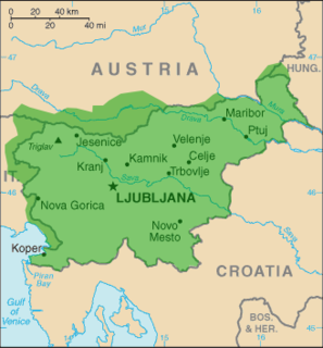
Slovene language language spoken in Slovenia

Slovene or Slovenian belongs to the group of South Slavic languages. It is spoken by approximately 2.5 million speakers worldwide, the majority of whom live in Slovenia. It is the first language of about 2.1 million Slovenian people and is one of the 24 official and working languages of the European Union.

Municipality An administrative division having corporate status and usually some powers of self-government or jurisdiction

A municipality is usually a single administrative division having corporate status and powers of self-government or jurisdiction as granted by national and regional laws to which it is subordinate. It is to be distinguished (usually) from the county, which may encompass rural territory or numerous small communities such as towns, villages and hamlets.

Slovenske Konjice Town and municipality in Slovenia

Slovenske Konjice is a town and a municipality in northeastern Slovenia. The area was part of the traditional region of Styria.

A Roman-era archaeological site in the hamlet of Podmočle in the settlement has been partially excavated and identified as a possible site of a Villa rustica. [3]

Ancient Rome History of Rome from the 8th-century BC to the 5th-century

In historiography, ancient Rome is Roman civilization from the founding of the Italian city of Rome in the 8th century BC to the collapse of the Western Roman Empire in the 5th century AD, encompassing the Roman Kingdom, Roman Republic and Roman Empire until the fall of the western empire. The civilization began as an Italic settlement in the Italian Peninsula, conventionally founded in 753 BC, that grew into the city of Rome and which subsequently gave its name to the empire over which it ruled and to the widespread civilisation the empire developed. The Roman Empire expanded to become one of the largest empires in the ancient world, though still ruled from the city, with an estimated 50 to 90 million inhabitants and covering 5.0 million square kilometres at its height in AD 117.

Archaeological site Place in which evidence of past activity is preserved

An archaeological site is a place in which evidence of past activity is preserved, and which has been, or may be, investigated using the discipline of archaeology and represents a part of the archaeological record. Sites may range from those with few or no remains visible above ground, to buildings and other structures still in use.

Excavation (archaeology) Exposure, processing and recording of archaeological remains

In archaeology, excavation is the exposure, processing and recording of archaeological remains. An excavation site or "dig" is a site being studied. Such a site excavation concerns itself with a specific archaeological site or a connected series of sites, and may be conducted over as little as several weeks to over a number of years.

Related Research Articles

Verpete in Styria, Slovenia

Verpete is a settlement in the Municipality of Vojnik in eastern Slovenia. It lies on the main road from Vojnik towards Slovenske Konjice, just north of Frankolovo. The area was traditionally part of the Styria region. It is now included with the rest of the municipality in the Savinja Statistical Region.

Zgornje Laže in Styria, Slovenia

Zgornje Laže is a small settlement in the Municipality of Slovenske Konjice in eastern Slovenia. It lies in the hills north of Spodnje Laže. Traditionally the area was part of Styria. The entire municipality is now included in the Savinja Statistical Region.

Bezina in Styria, Slovenia

Bezina is a settlement in the Municipality of Slovenske Konjice in eastern Slovenia. It lies on the regional road leading north from Slovenske Konjice to Oplotnica. The area is part of the traditional region of Styria. The municipality is now included in the Savinja Statistical Region.

Blato, Slovenske Konjice Place in Styria, Slovenia

Blato is a small settlement in the Municipality of Slovenske Konjice in eastern Slovenia. It lies under the northeastern slopes of Mount Konjice, just southeast of Slovenske Konjice itself. The area is part of the traditional region of Styria. The municipality is now included in the Savinja Statistical Region.

Draža Vas Place in Styria, Slovenia

Draža Vas is a settlement in the Municipality of Slovenske Konjice in eastern Slovenia. It lies on the Dravinja River east of Slovenske Konjice. The area is part of the traditional region of Styria. The municipality is now included in the Savinja Statistical Region.

Kamna Gora Place in Styria, Slovenia

Kamna Gora is a settlement in the Municipality of Slovenske Konjice in eastern Slovenia. It lies on the southern slopes of Mount Konjice. The area is part of the traditional region of Styria and is now included in the Savinja Statistical Region.

Nova Vas pri Konjicah Place in Styria, Slovenia

Nova Vas pri Konjicah is a small settlement in the Municipality of Slovenske Konjice in eastern Slovenia. The A1 Slovenian motorway runs through the settlement. Traditionally the area was part of Styria. The municipality is now included in the Savinja Statistical Region.

Perovec in Styria, Slovenia

Perovec is a small settlement in the Municipality of Slovenske Konjice in eastern Slovenia. It lies north of Draža Vas, just east of the Slovenian A1 motorway. The area is part of the traditional region of Styria. The municipality is now included in the Savinja Statistical Region.

Polene Place in Styria, Slovenia

Polene is a settlement in the Municipality of Slovenske Konjice in eastern Slovenia. It lies under the northern slopes of the Mount Konjice hills west of Slovenske Konjice. The area is part of the traditional region of Styria. The municipality is now included in the Savinja Statistical Region.

Sojek Place in Styria, Slovenia

Sojek is a small settlement in the Municipality of Slovenske Konjice in eastern Slovenia. It lies dispersed on the southern slopes of the Mount Konjice hills southwest of Slovenske Konjice. The area of the entire Municipality of Slovenske Konjice was traditionally part of the Styria region and is now included in the Savinja Statistical Region.

Spodnja Pristava in Styria, Slovenia

Spodnja Pristava is a small settlement in the Municipality of Slovenske Konjice in eastern Slovenia. It lies on the right bank of the Dravinja River just west of Draža Vas. The area is part of the traditional region of Styria and is now included in the Savinja Statistical Region.

Spodnji Jernej in Styria, Slovenia

Spodnji Jernej is a settlement in the hills northeast of Loče in the Municipality of Slovenske Konjice in eastern Slovenia. Traditionally the area was part of the Styria region. The municipality is now included in the Savinja Statistical Region. In 1999 a part of the settlement was administratively separated to form the new settlement of Štajerska Vas.

Stare Slemene Place in Styria, Slovenia

Stare Slemene is a settlement in the Municipality of Slovenske Konjice in eastern Slovenia. The area is part of the traditional region of Styria. The municipality is now included in the Savinja Statistical Region.

Štajerska Vas Place in Styria, Slovenia

Štajerska Vas is a small village in the Municipality of Slovenske Konjice in eastern Slovenia. It lies immediately northeast of Loče. The area is part of the traditional region of Styria and is now included in the Savinja Statistical Region. The settlement of Štajerska Vas was created in 1999, when it was administratively separated from Spodnji Jernej.

Tolsti Vrh, Slovenske Konjice Place in Styria, Slovenia

Tolsti Vrh is a settlement in the Municipality of Slovenske Konjice in eastern Slovenia. It lies on the southern slopes of the Mount Konjice hills south of the town of Slovenske Konjice. The area is part of the traditional region of Styria. The municipality is now included in the Savinja Statistical Region.

Vešenik in Styria, Slovenia

Vešenik is a settlement in the Municipality of Slovenske Konjice in eastern Slovenia. It lies in the hills immediately northeast of Slovenske Konjice. The area is part of the traditional region of Styria. When statistical regions were created in Slovenia in 2007, the Municipality of Slovenske Konjice was included in the Savinja Statistical Region.

Zbelovo Village in Styria, Slovenia

Zbelovo is a village in the Municipality of Slovenske Konjice in eastern Slovenia. It lies on the left bank of the Dravinja River. The area is part of the traditional region of Styria. The municipality is now included in the Savinja Statistical Region.

Zbelovska Gora Place in Styria, Slovenia

Zbelovska Gora is a settlement in the Municipality of Slovenske Konjice in eastern Slovenia. It lies in the hills above the right bank of the Dravinja River. The area is part of the traditional region of Styria. The municipality is now included in the Savinja Statistical Region.

Zeče, Slovenske Konjice in Styria, Slovenia

Zeče is a settlement in the Municipality of Slovenske Konjice in eastern Slovenia. It lies in the hills northwest of Slovenske Konjice, off the main regional road to Zreče. The area is part of the traditional region of Styria. The municipality is now included in the Savinja Statistical Region.

Zgornja Pristava, Slovenske Konjice Place in Styria, Slovenia

Zgornja Pristava is a settlement in the Municipality of Slovenske Konjice in eastern Slovenia. It lies south and west of Slovenske Konjice and its territory extends to the top of Mount Konjice. The area is part of the traditional region of Styria. The municipality is now included in the Savinja Statistical Region.

References