
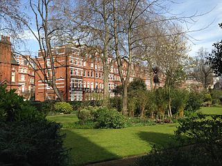
Drayton Gardens is a residential street linking the areas of Chelsea and South Kensington, London SW10. It runs roughly north to south from Old Brompton Road to Fulham Road.
Drayton Gardens is a residential street linking the areas of Chelsea and South Kensington, London SW10. It runs roughly north to south from Old Brompton Road to Fulham Road.

Drayton Gardens was once a "rustic lane" in the hamlet of Brompton, lined with a mix of market gardens and country houses, until more suburban villas began to be built in the early 1800s. [1] Later, some of the older houses were demolished, and mansion blocks appeared, including Drayton Court in 1902, and Onslow Court in 1935. [1]
The northern half (1-39 and 4-56) formed part of the Day Estate, and was a three-acre field known as Rosehall or Rose Hawe, which the Day family acquired by the marriage in 1743 of Benjamin Day, the son of a wealthy Norwich weaver, to Ann Dodemead, daughter and co-heir of Walter Dodemead of Covent Garden. [2]
Scientist Rosalind Franklin, who discovered the structure of DNA, lived at number 107 (Donovan Court) until her death, and in 1992, English Heritage placed a commemorative blue plaque. [3] [4]
The socialite Dorothy Fellowes-Gordon and her lifelong companion, the gossip columnist Elsa Maxwell lived there from 1912. [5]
In 1926, Margery Blackie, homeopath to Queen Elizabeth II, established a practice there.
Bolton's Picture Playhouse, which opened in 1911, gave way to Bolton's Theatre Club in 1947. Until the passage of Theatres Act 1968, all public performances were subject to censorship, but by operating as a private members' club, the theatre was able to circumvent this requirement. Many of these plays transferred to the West End. After closure and conversion, the building was reopened in 1955 by James Quinn as the Paris Pullman Cinema, which showed art-house films. The final closure came in 1983, when the building was demolished and replaced by a block of flats.
From 1960 until his death in 1968, the author and artist Mervyn Peake lived at no 1. His widow Maeve Gilmore, artist and memoirist, continued to live there until her death, having decorated the house with murals.
Adelaide Hall, the jazz singer and entertainer, lived at no 74, with her husband Bert Hicks. Sir William Arbuthnot Lane, 1st Baronet and Lady Frittie Arbuthnot Lane lived next door at no 72.
St John Philby, the orientalist and explorer, lived in Grove Court in a flat belonging to his wife Dora. It was there that his son Kim Philby, the notorious NKVD/KGB agent, betrayed Erich Vermehren to the Russians after his defection from the German Abwehr to MI6 in 1944; and where ten years later he organised a press conference at which he temporarily convinced the public that he was not the "Fourth Man".

Kensington is an area of London in the Royal Borough of Kensington and Chelsea, around 2.9 miles (4.6 km) west of Central London.

The Royal Borough of Kensington and Chelsea is an Inner London borough with royal status. It is the smallest borough in London and the second smallest district in England; it is one of the most densely populated administrative regions in the United Kingdom. It includes affluent areas such as Notting Hill, Kensington, South Kensington, Chelsea, and Knightsbridge.
Earl's Court is a district of Kensington in the Royal Borough of Kensington and Chelsea in West London, bordering the rail tracks of the West London line and District line that separate it from the ancient borough of Fulham to the west, the sub-districts of South Kensington to the east, Chelsea to the south and Kensington to the northeast. It lent its name to the now defunct eponymous pleasure grounds opened in 1887 followed by the pre–World War II Earls Court Exhibition Centre, as one of the country's largest indoor arenas and a popular concert venue, until its closure in 2014.

South Kensington is a district just west of Central London in the Royal Borough of Kensington and Chelsea. Historically it settled on part of the scattered Middlesex village of Brompton. Its name was supplanted with the advent of the railways in the late 19th century and the opening and naming of local tube stations. The area has many museums and cultural landmarks with a high number of visitors, such as the Natural History Museum, the Science Museum and the Victoria and Albert Museum. Adjacent affluent centres such as Knightsbridge, Chelsea and Kensington, have been considered as some of the most exclusive real estate in the world.

Old Brompton Road is a major street in the South Kensington district of The Royal Borough of Kensington and Chelsea, London.

Gloucester Road is a street in the Royal Borough of Kensington and Chelsea, London. It runs north–south between Kensington Gardens and Old Brompton Road.

West Kensington, formerly North End, is an area in the ancient parish of Fulham, in the London Borough of Hammersmith and Fulham, England, 3.4 miles (5.5 km) west of Charing Cross. It covers most of the London postal area of W14, including the area around Barons Court tube station, and is defined as the area between Lillie Road and Hammersmith Road to the west, Fulham Palace Road to the south, Hammersmith to the north and West Brompton and Earl's Court to the east. The area is bisected by the major London artery the A4, locally known as the Talgarth Road. Its main local thoroughfare is the North End Road.

Brompton, sometimes called Old Brompton, survives in name as a ward in the Royal Borough of Kensington and Chelsea in London. Until the latter half of the 19th century it was a scattered village made up mostly of market gardens in the county of Middlesex. It lay southeast of the village of Kensington, abutting the parish of St Margaret's, Westminster at the hamlet of Knightsbridge to the northeast, with Little Chelsea to the south. It was bisected by the Fulham Turnpike, the main road westward out of London to the ancient parish of Fulham and on to Putney and Surrey. It saw its first parish church, Holy Trinity Brompton, only in 1829. Today the village has been comprehensively eclipsed by segmentation due principally to railway development culminating in London Underground lines, and its imposition of station names, including Knightsbridge, South Kensington and Gloucester Road as the names of stops during accelerated urbanisation, but lacking any cogent reference to local history and usage or distinctions from neighbouring settlements.

West Brompton is an area of west London, England, that straddles the boundary between the London Borough of Hammersmith and Fulham and Royal Borough of Kensington and Chelsea. The centuries-old boundary traced by Counter's Creek, probably marked the eastern edge of Fulham Manor since Saxon times and is now partly lost beneath the West London Line railway.

Old Church Street is a street in London, England in the Royal Borough of Kensington and Chelsea.

Bolton's Theatre Club in Drayton Gardens, Brompton, London launched in 1947 in a building originally opened in 1911 as the Radium Picture Playhouse. By operating as a club where membership was obligatory, the theatre was able to stage plays which might otherwise be prohibited under the Theatres Act 1843. Many of its plays transferred to the West End.

The Boltons is a street and garden square of lens shape in the Brompton district of the Royal Borough of Kensington and Chelsea, London, England. The opposing sides of the street face the communal gardens with large expansive houses and gardens, in what is considered the second most expensive street in the country with an average house price of £23.1m. The elliptical central gardens of the Boltons are Grade II listed on the Register of Historic Parks and Gardens.

Redcliffe Square is a town square located in the Brompton area of the Royal Borough of Kensington and Chelsea, southwest of central London,. Redcliffe Square Gardens are located in the square. The development was part of the vast Gunter estate, during 1864–1878.

Redcliffe Gardens is a primary road, the A3220 located in the Chelsea area of southwest central London, England. It was a development dated from 1864 to 1878.

Onslow Square is a garden square in South Kensington, London, England.
James Gunter was an English confectioner, market gardener and property developer who laid the foundations for what became one of the great residential estates in West London, developed by his descendants, the "Redcliffe Estate" and The Boltons in Little Chelsea and West Brompton.

Brompton Square is a garden square in London's Brompton district, in the Royal Borough of Kensington and Chelsea.
Egerton Gardens is a street and communal garden, regionally termed a garden square, in South Kensington, London SW3.
The Paris Pullman is a former arthouse cinema, in the Brompton district, of the Royal Borough of Kensington and Chelsea London, England. It was closed and the building sold for redevelopment in 1983.
![]() Media related to Drayton Gardens at Wikimedia Commons 51°29′19″N0°10′52″W / 51.4886°N 0.1810°W
Media related to Drayton Gardens at Wikimedia Commons 51°29′19″N0°10′52″W / 51.4886°N 0.1810°W