Druridge Bay Country Park

Last updated

Druridge Bay Country Park
Ladyburn Lake at Druridge Bay Country Park.jpg
Ladyburn Lake at Druridge Bay Country Park
Northumberland UK location map.svg
Red pog.svg
Type Country park
Location Druridge Bay, Northumberland
Nearest town Amble
OS grid NU269000 [1]
Coordinates 55°17′38″N1°34′37″W / 55.294°N 1.577°W / 55.294; -1.577 Coordinates: 55°17′38″N1°34′37″W / 55.294°N 1.577°W / 55.294; -1.577 [1]
Area65.8 acres (26.6 ha)
Elevation21 feet (6.3 m)
Established1970 (open 1989)
Operated by Northumberland County Council
OpenAll year
Designation Northumberland Shore SSSI (partial)
Parking Pay and display
Public transit access Hadston, Red Row; bus service 518
Website Official website

Druridge Bay Country Park is adjacent to Druridge Bay between Amble and Cresswell, on the coastline of Northumberland, England. The country park was opened officially in 1989, but works had been ongoing since the 1970s to remediate the site after opencast coaling operations. The park is accessible by vehicle from the A1068 road, and is located on the England Coast Path. Public transport can be taken near to the park's closest village, which involves a 15-minute walk to get to the park.

Contents

History

The eastern edge of the park, where it meets the coastline, was used in the Second World War as an aerial gunnery and target practice range. This was administered by the nearby RAF Acklington station. [2] Opencasting and quarrying were the previous industries in the area, and when these ceased, the site was redeveloped into a country park. [3] Coal has been worked in the area progressively since the 1940s, which has left several large ponds and pools as an after effect of the coaling operations. Druridge Country Park is situated mostly on the former Coldrife surface mine, [4] which was granted permission in 1965 and worked progressively over eight years. [5]

The lake is fed by Lady Burn, and was created in the early 1970s, starting to fill with water from 1971. [6] However, the water leaked out through old mine workings and had emptied by 1974. In 1983, clay from nearby coal workings was used to re-line the bottom of the lake and it was allowed to refill. [7]

The park is 12 miles (19 km) south east of Alnwick, [8] 3 miles (4.8 km) south of Amble, [9] and 4 miles (6.4 km) north of Widdrington. [10] It has a junction off the A1068 road, and is also accessible by bus from the nearby villages of Hadston and Red Row (No. 518, which includes a 15-minute walk to the country park). [11] [12]

Whilst access was available for some time before official opening, [7] the park was deemed to have been opened in July 1989 when the visitor centre was unveiled. [13] In 1992, the Northumberland Shore SSSI was established, with the easternmost part of the park falling withing the zone of the SSSI. [14] In 2000, the park attracted 100,000 visitors [15] Further investment in 2020 included a refurbishment of the visitor centre and the creation of an area for caravans and campers. [16] Management of the park is undertaken by Northumberland County Council. [17]

Activities

The park covers an area of 65.8 acres (26.6 ha) [9] with the centrepiece being the 25-acre (10-hectare), 16-foot (4.9 m) deep Ladyburn Lake. [18] [19] The lake is used for variety of watersports such as kayaking, sailing, [20] paddleboarding, windsurfing, canoeing, [21] and wild swimming. [22] The park has a visitor centre, cafe, toilets, a play park and is wheelchair accessible. [12] [23] Walking is another popular activity and the eastern edge of the site has the England Coastal Path running through it. [24]

The park was the setting of time trials for the 1995 World Cross Country running championships, [25] and the national triathlon championships in 2009. [26]

Wildlife

Birds are particularly prevalent in the park as it is near the coast and has standing water. Those spotted at the park are bullfinch, crossbill, kingfisher, redpoll, siskin, willow tit, gadwall, red-breasted mergansers, and long-tailed duck. During the winter, the coast and park are host to divers, grebes, geese, whooper and bewick swans. [27] [28]

Related Research Articles

Northumberland County of England

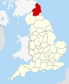
Northumberland is a ceremonial county and historic county in North East England. It is bordered by the Scottish Borders to the north, Cumbria to the west, and both County Durham and Tyne and Wear to the south. To the east is the North Sea coastline with a path 103 kilometres (64 mi) long. The county town of Northumberland is Alnwick. The county is administered as a unitary authority by Northumberland County Council, headquartered in Morpeth.

Amble Human settlement in England

Amble is a town on the North Sea coast of Northumberland, England, at the mouth of the River Coquet; Coquet Island is visible from its beaches and harbour. In 2011, it had a population of 6,025.

Alnwick District Former District in England

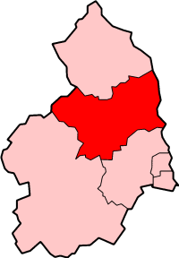
Alnwick was a local government district of Northumberland, England. Its council was based in Alnwick town and the district had a population of 31,029 according to the 2001 census.

Cambois Human settlement in England

Cambois is a village in south-east Northumberland, England. It is situated on the north side of the estuary of the River Blyth between Blyth and Ashington on the North Sea coast.

Pegswood Human settlement in England

Pegswood is a mining village and civil parish in Northumberland, England, and the site of the former Pegswood Colliery. Pegswood is two miles (3 km) east of Morpeth and three miles (5 km) west of Ashington, with a population of around 3,280. Pegswood is on a small hill above the valley in which Morpeth is situated, close to the River Wansbeck and to the river Brocks Burn.

Druridge Bay Coastal feature in Northumberland, England

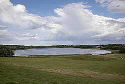
Druridge Bay is a 7-mile (11 km) long bay on the North Sea in Northumberland, England, stretching from Amble in the north to Cresswell in the south.

River Allen, Northumberland River in Northumberland, England

The River Allen is a river in the English county of Northumberland. The river has its sources in the hills of the Northern Pennines, and is formed by the confluence of the East and West Allen rivers. The Allen is itself, a tributary of the River Tyne. The Allen was formerly very polluted from mining activity upstream, but remediation schemes have been implemented to allow the water quality to improve.

Northumberland Fire and Rescue Service Fire and Rescue Service in North-East England

Northumberland Fire and Rescue Service is the statutory fire and rescue service which covers the area of Northumberland, England. Its headquarters are located at West Hartford fire station in Cramlington.

Ashington Town and parish in Northumberland, England

Ashington is a town and civil parish in Northumberland, England, with a population of 27,864 at the 2011 Census. It was once a centre of the coal mining industry. The town is 15 miles (24 km) north of Newcastle upon Tyne, west of the A189 and bordered to the south by the River Wansbeck. The North Sea coast at Newbiggin-by-the-Sea is 3 miles (5 km) away.

Hadston Human settlement in England

Hadston is a village in Northumberland, England about 2.5 miles (4 km) south of Amble, Northumberland.

Northumberland Astronomical Society Observatory

The Northumberland Astronomical Society was founded in 2000 by local amateur astronomers in Northumberland, UK. The society is informally known among its members as "NASTRO". The first formal meetings of the society were held in the village hall at Low Hauxley but increasing membership and the support of the Northumberland Wildlife Trust saw meetings move to the visitor centre in the nearby Hauxley Nature Reserve in 2002. The Nature Reserve was burned down in an arson attack on 29 June 2010, so society meetings are now held in the Beehive function room at The Trap Inn until the new building is completed, which is expected to be in 2017.

Open-pit coal mining in the United Kingdom is in decline. Output has fallen every year since 2010. In 2010, the United Kingdom was forecast to produce about ten million tonnes of coal a year from open-pit mines. Most came from Scotland, with the largest operator there being the Scottish Coal subsidiary of Scottish Resources Group. Actual production in 2010 was over 13 million tonnes but this has declined to less than 8 million tonnes in 2014. Deep coal mining stopped completely at the end of 2015 and the UK is planning to phase out the use of coal to produce electricity by 2024.

Coal mining in the United Kingdom Fossil fuel from underground

Coal mining in the United Kingdom dates back to Roman times and occurred in many different parts of the country. Britain's coalfields are associated with Northumberland and Durham, North and South Wales, Yorkshire, the Scottish Central Belt, Lancashire, Cumbria, the East and West Midlands and Kent. After 1972, coal mining quickly collapsed and had practically disappeared by the 21st century. The consumption of coal – mostly for electricity – fell from 157 million tonnes in 1970 to 18 million tonnes in 2016, of which 77% was imported from Colombia, Russia, and the United States. Employment in coal mines fell from a peak of 1,191,000 in 1920 to 695,000 in 1956, 247,000 in 1976, 44,000 in 1993, and to 2,000 in 2015.

Ellington Colliery Former colliery in Northumberland, England

Ellington Colliery, was a coal mine situated to the south of the village of Ellington in Northumberland, England. The colliery was the last deep coal mine in the north east of England. At one time, the deepest part of the mine was 800 metres (2,600 ft) and it extended 15 miles (24 km) under the North Sea. During the 1980s, the pit was known as the biggest undersea mine in the world and produced 69% of the mined coal in Northumberland.

Alnwick RFC is an amateur rugby union club based in the town of Alnwick, Northumberland in north-east England. The club play in North Premier, a level five league in the English rugby union system and are the most northerly rugby union club in English league rugby,. Alnwick regularly field three senior sides, all of which play competitive league and cup rugby. The club also has a junior section running teams from under 7's through to under 18's and a girls section.

Shotton Surface Mine

Shotton Surface Mine is an open cast coal mine located on the estate of Blagdon Hall, Northumberland, UK, operated by Banks Group. The mine was granted permission by the government in 2007, despite being refused permission by Blyth Valley Council, with an initial agreement to mine 3.4 million tonnes of coal, 2 million tonnes of shale and 750,000 tonnes of fireclay. This was subsequently extended by two years in 2011 to allow an additional 2 million tonnes of coal to be mined, set to end in 2016. An additional expansion approved in 2014 saw two new pits being opened on the site, Shotton Triangle and Shotton South West, with the end date pushed back a year to October 2017; the land was expected to be restored by 2019. The mine eventually ceased production in summer 2020.

The geology of Northumberland in northeast England includes a mix of sedimentary, intrusive and extrusive igneous rocks from the Palaeozoic and Cenozoic eras. Devonian age volcanic rocks and a granite pluton form the Cheviot massif. The geology of the rest of the county is characterised largely by a thick sequence of sedimentary rocks of Carboniferous age. These are intruded by both Permian and Palaeogene dykes and sills and the whole is overlain by unconsolidated sediments from the last ice age and the post-glacial period. The Whin Sill makes a significant impact on Northumberland's character and the former working of the Northumberland Coalfield significantly influenced the development of the county's economy. The county's geology contributes to a series of significant landscape features around which the Northumberland National Park was designated.

Prince of Wales Colliery Former colliery in West Yorkshire, England

The Prince of Wales Colliery, was a coal mine that operated for over 130 years in Pontefract, West Yorkshire, England. It was permanently closed in 2002 after geological problems were found to make accessing remaining coal reserves unprofitable, and most of the site was later converted for housing.

Skelton Lake services Motorway service station in West Yorkshire, England

Skelton Lake services is a motorway service area operated by Extra, on the M1 motorway near Leeds, West Yorkshire, England. It is located on Junction 45 of the Motorway which also links into the A63. It lies on the south side of the motorway; however, the junction affords access to, and from, all directions.

North Steads Wind Farm Wind farm in Northumberland, England

North Steads Wind Farm, is an onshore electricity generating site west of Widdrington in Northumberland, England. The site was developed on old coal opencast workings and has nine turbines delivering over 18 megawatts of power per year.

References

  1. 1 2 "Ladyburn Lake, Northumberland". getoutside.ordnancesurvey.co.uk. Retrieved 2 August 2021.
  2. "Druridge Bay Air Gunnery and Bombing Range" (PDF). assets.publishing.service.gov.uk. 1939. pp. 6, 15. Retrieved 2 August 2021.
  3. "Durham Mining Museum - Druridge Opencast". www.dmm.org.uk. Retrieved 3 August 2021.
  4. "Highthorn Proposed Surface Mine" (PDF). banks group.co.uk. p. 3. Retrieved 5 August 2021.
  5. "Opencast Mining Site, Coldrife - Tuesday 23 November 1965 - Hansard - UK Parliament". hansard.parliament.uk. Retrieved 3 August 2021.
  6. Tandy, Cliff (1975). Landscape of industry. London: L. Hill. p. 169. ISBN   0-2494-4139-X.
  7. 1 2 Smith, Ian (1988). Northumbrian coastline : Berwick-upon-Tweed to North Shields. Alnwick: Sandhill Press. p. 87. ISBN   0-946098-10-7.
  8. Long, Peter; McMartin, K. E.; Palese, M.; Tephly, T. R. (2005). The hidden places of Northumberland and Durham (6 ed.). Aldermaston: Travel. p. 84. ISBN   1904434371.
  9. 1 2 "Druridge Bay Country Park". woodlandtrust.org.uk. Retrieved 3 August 2021.
  10. Gillham, John (2014). 50 walks in Durham & Northumberland : 50 walks of 2-10 miles (3 ed.). Basingstoke, Hampshire: AA Publishing. p. 82. ISBN   9780749575670.
  11. "Newcastle - Morpeth - Amble - Alnwick 518" (PDF). travelnortheast.co.uk. Retrieved 3 August 2021.
  12. 1 2 Abbott, Louise, ed. (2009). Where to go wild in Britain. London: Dorling Kindersley. p. 20. ISBN   978-1-4053-3512-6.
  13. "From Coal Mine to Country Park". The Planner. London: Royal Town Planning Institute. 75 (11–35): 6. 28 July 1989. ISSN   0309-1384.
  14. "Northumberland Shore" (PDF). designatedsites.naturalengland.org.uk. Retrieved 3 August 2021.
  15. "Ryder Cup bid aided by 'Oscar' for hotel" . infoweb.newsbank.com. 27 October 2000. Retrieved 2 August 2021.
  16. Smith, Ian (2 July 2020). "£300,000 refurbishment of Northumberland coast visitor centre finished". www.northumberlandgazette.co.uk. Retrieved 3 August 2021.
  17. "Northumberland and North Tyneside Shoreline Management Plan 2" (PDF). northumberland.gov.uk. p. 196. Retrieved 5 August 2021.
  18. Fisher, Stuart G. (2019). Coastal Britain : England & Wales : celebrating the history, heritage and wildlife of Britain's shores. London: Adlard Coles. p. 52. ISBN   978-1472958693.
  19. "Northumberland Coast Visitor Guide". northumberlandcoastaonb.org. p. 56. Retrieved 2 August 2021.
  20. Hall, Gemma (2019). Northumberland : including Hadrian's Wall and the coast : local, characterful guides to Britain's special places (2 ed.). Chalfont St Peter, Bucks, England: Bradt. p. 57. ISBN   9781784776084.
  21. Hall, Gemma (2012). Slow Northumberland & Durham : including the border country, Newcastle & Hadrian's Wall. Chalfont St. Peter: Bradt Travel Guides. p. 63. ISBN   9781841624334.
  22. "Ladyburn Lake". outdoorswimmer.com. Retrieved 3 August 2021.
  23. "Alnmouth to Druridge Bay". sustrans.org.uk. Retrieved 3 August 2021.
  24. "44-mile public path opens up North East coastline". www.northumberlandgazette.co.uk. 26 July 2018. Retrieved 3 August 2021.
  25. Powell, David (4 March 1995). "Top runners ignore cross country trials". The Times (65, 206). p. 38. ISSN   0140-0460.
  26. "Athletes set for heartbreak Ridge" . infoweb.newsbank.com. 18 June 2009. Retrieved 2 August 2021.
  27. Almond, John (20 December 2014). "Milder weather makes some linger for longer" . infoweb.newsbank.com. Retrieved 5 August 2021.
  28. "Druridge Bay Country Park". birdwatchingsites.co.uk. 23 September 2014. Retrieved 5 August 2021.